The Smithtown Library's Main Branch. Photo courtesy of smithlib.org
Smithtown Special Library District Board of Trustees adopt resolution to moveforward with public vote on financing for capital improvement project Public vote to be held on Tuesday, July 1
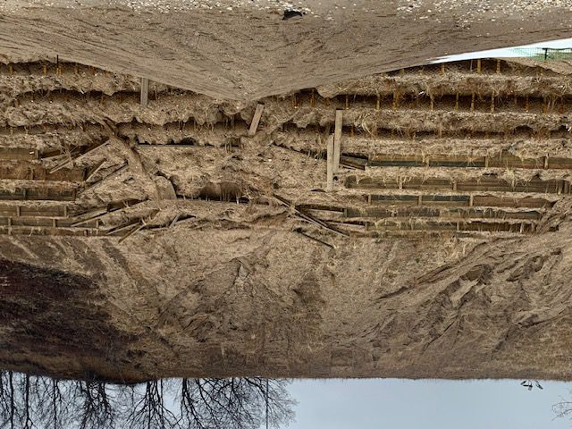
At its May 6 special meeting, the Board of Trustees of the Smithtown Special LibraryDistrict adopted a resolution to proceed with a community vote on Tuesday, July 1, on thefinancing of capital improvement work. The Board is proposing renovations to theLibrary’s Smithtown Building, located at One North Country Road, to address damagecaused by the catastrophic storm of August 2024.
“As most residents are aware, the Smithtown Building suffered devastating damageto its lower level due to the tremendous level of flooding experienced from the storm,” Library Director Rob Lusak said. “The lower level remains unusable and in need ofsignificant renovations. It is our hope to reimagine and rebuild the space so that it can onceagain serve as a vital resource for the community.”
Funding will be used to renovate the space to house the Library’s LearnLab (themakerspace area), a podcast studio for community use, study areas and room for LiteracySuffolk, which provides literacy services to adults.
Additionally, the lower level will accommodate the Library’s newly establishedGovernment Services Department, which will house the Patent and Trademark ResourceCenter and Passport Acceptance Facility. It will also house the Library’s new FederalDepository Library collection, which will provide free and open access to governmentdocuments.
“Our Library was designated as a federal depository library last summer; however,due to the flood, we were not able to allocate space for this collection,” Lusak said. “We’repleased to make this significant addition available to the community.”
The Richard H. Handley Collection of Long Island Americana (better known toresidents as the “Long Island Room”) will be relocated to the first floor of the building inmuseum-quality shelving with temperature and humidity controls, UV-protective glass andother archival standards in place to preserve and protect the historic documents.
The total cost of the proposed construction is not to exceed $16.5 million. While it isanticipated that FEMA funding and/or funds from other sources will be used to pay orreimburse all or most of the improvement costs, the Library must plan to finance the fullamount to ensure the project can move forward without delay, regardless of the timing oravailability of outside funding.
This will be done using a combination of bond financing (including the use of bondanticipation notes, “BANS”) to fund the work in a responsible and cost-effective manner.BANs are one-year notes that allow the Library to begin construction while it waits forreimbursement from FEMA. This approach affords the Library the flexibility to finance onlythat which it needs and therefore potentially reduce borrowing costs. Once the project isunderway, the Town may issue long-term bonds to repay the BANs and spread the cost ofthe improvements over time.
Should FEMA and/or alternate funding not be available (as unlikely as that may be),the anticipated cost of the project to the average homeowner in the Smithtown SpecialLibrary District is estimated to not exceed $36 per year for the maximum 15-year term ofthe financing.
The referendum will be held on Tuesday, July 1 from 9:30am to 9:00pm at all fourLibrary buildings. Polling sites are determined by a resident’s home address and the SuffolkCounty election districts.
A Community Open House information session is scheduled for residents onTuesday, June 24, from 7:00-9:00pm at the Smithtown Building, located at One NorthCountry Road. All Smithtown Library District residents are encouraged to attend to learnmore about the proposal and ask any questions they may have prior to the vote.
“Our libraries are at the heart of the Smithtown community and provide vitalresources and programs for residents of all ages,” Lusak said. “I encourage communitymembers to learn more about the proposal and how we are reimagining a new chapter forour building, and to participate in the vote on July 1.”
All information related to the proposal, as well as detailed voting information, canbe found on the Library’s website, www.smithlib.org. A special mailer will be sent to allSmithtown Library District residents in June detailing the bond proposition.
Damage to a home and vehicle from the Eaton Fire in northern Altadena, California in January 2025. Photo from Wikimedia Commons. Public Domain
By Leah S. Dunaief
Leah Dunaief, Publisher
It may have started as a new year filled with hope, but this is a difficult week. The terrible fires in Southern California have burned entire neighborhoods to the ground, from mansions to mobile homes. We already know about the displaced and the deaths, but more destruction may yet come. Weather forecasts from the National Weather Service are predicting fierce winds ahead that may drive the fires into new areas.
The end is not in sight.
While this horror is on the other side of the country, it is not remote. Many of us have friends and relatives who live, work, study or are retired there, driving the tragedy right into our midst and into our hearts in a deeply personal way. These are not only abstract numbers of people and homes about which we would feel a humanitarian empathy. These are our people. These are our forests and our lands. The dreadful irony of it all, remembering the 1972 Albert Hammond song, “It Never Rains in Southern California.”
While there was already a serious homeless population for Los Angeles, the newly displaced are trying to figure out what to do next. The lucky ones have relatives or friends with whom they can seek shelter. It may be long weeks, even months before they can return, if their homes miraculously are still standing. What if they are not? Will the insurance companies hold up to enable rebuilding, or will some of them declare bankruptcy, as they have done in similar cataclysmic situations, like the one in the Caribbean Island St. Croix? Can FEMA bear the entire load?
Private citizens can be counted on to respond generously, as we have with virtually every disaster in the world. With such an enormous catastrophe, the entire national economy could take a hit. How will the new administration respond?
Speaking of the government, we have less than a week before the new administration is sworn into office. The change of political parties may in itself contribute to some emotional reaction this week, regardless of one’s party affiliation.
Many Dems are worried, while many members in the GOP are optimistic. There has been much talk of changes to come, from buying Greenland for its exotic minerals to changing the name from the Gulf of Mexico to the Gulf of America. Perhaps more seriously, there may be a tax cut in the future, some change in immigration policy and new tariffs imposed or at least threatened.
Some good news did emerge this week. There may be a truce in Gaza after 15 months of violence, with some hostages to be exchanged for Palestinian prisoners and specific movements of Israeli troops. While the atmosphere surrounding the peace talks remains tense, according to media reports, there now seems some hope.
According to Secretary of State Antony Blinken, the negotiators are only awaiting Hamas’s sign off. Perhaps the imminent changeover of presidents from Biden to Trump in the United States hastened the deal. The governments of Qatar and Egypt have also directly participated in the talks.
Perhaps now the fighting in Ukraine and the fires in Southern California can also be brought to a halt. Then we could return to hope.
The Town of Smithtown Department of Public Safety employees. Photo courtesy Town of Smithtown
The Town of Smithtown Department of Public Safety has been awarded $200,000 through the Federal Emergency Operations Centers (EOC) Grant Program provided by FEMA to enhance the town’s emergency preparedness. Announced by Gov. Kathy Hochul, the funding will allow Smithtown to upgrade its Emergency Operations Center (EOC) facilities, improving coordination and response during crises.
“Effective communication during a disaster is the cornerstone of emergency management. We’re especially grateful to Gov. Hochul for this funding, which will allow the Town of Smithtown to enhance our local emergency operations facilities, ensuring we are well-equipped to protect our residents and coordinate response efforts during emergencies,” said Supervisor Edward R. Wehrheim (R.)
“I am pleased to see that we have been awarded the grant to update and improve our Emergency Operations Center. With these funds we will reconfigure the EOC, replace antiquated equipment and enhance our interoperability with partner police and fire agencies. This center is staffed 24/7 and our dispatchers will now have all the resources they need at their disposal, greatly enhancing our ability to serve residents not only during disasters but daily, ensuring we operate at the highest capabilities. I’d like to commend Deputy Director Caillat for her work on this project and securing this award,” said the director of public safety, Thomas Lohmann.
The EOC Grant Program supports projects that equip, upgrade and construct emergency operations centers, ensuring municipalities are ready to respond effectively to disasters. These improvements are key to a comprehensive national emergency management system enabling communication and collaboration among emergency organizations across multiple jurisdictions and hazards.
The Town of Smithtown remains steadfast in its commitment to public safety and emergency preparedness. This grant will enhance the town’s ability to respond efficiently to emergencies, supporting a unified approach to disaster management while safeguarding the community.
About the Emergency Operations Centers (EOC) Grant Program
The FEMA EOC Grant Program provides financial assistance to local, state and tribal governments to enhance emergency management capabilities. The program focuses on equipping, upgrading and constructing emergency operations centers to ensure communities are prepared for all-hazard events.
About the Town of Smithtown Emergency Management Unit
The Department of Public Safety serves as the town’s emergency management office and is actively involved in all phases of preparedness for natural and human-made disasters. To plan for disasters, the department coordinates drills with local fire departments, police and other emergency agencies. During actual emergencies, the department integrates activities from its own divisions and local, state and federal agencies. The department also maintains a townwide communications center, which serves as the hub of the Emergency Operations Center (EOC) during emergencies.
Gov. Hochul visits Stony Brook following Aug. 18 storm. File photo
By Lynn Hallarman
The Federal Emergency Management Agency denied requests from Gov. Kathy Hochul (D) on Nov. 14 to provide funding assistance for Suffolk County homeowners impacted by the severe flooding this past August.
Hochul requested disaster assistance from FEMA’s Public and Individual Assistance programs for Suffolk County in September in the wake of a relentless six-hour downpour in the early hours of Aug. 19.
Floodwaters from almost 11 inches of rain destroyed roads and damaged numerous residences and businesses across the North Shore of Suffolk County. Multiple swift water rescues occurred in the Town of Brookhaven, and flooding caused a breach of the Mill Pond Dam in Stony Brook Village causing six families to be displaced.
“Over 2,000 residents and business owners experienced flood damage in some capacity, and Stony Brook University had to relocate and/or shelter hundreds of students,” according to the statement released by the governor’s office shortly after the storm.
President Joe Biden (D), in October, approved a major disaster declaration for New York State for recovery efforts. The federal funding supports emergency work and repair by local governments and eligible private nonprofit organizations.
However, this aid funding does not include flood damage repair for individual households.
The November FEMA declaration denied Hochul’s request for aid to homeowners.
“It was determined that the damage was not of severity and magnitude to warrant a Federal Declaration for Individual Assistance,” said a statement from FEMA.
Rep. Nick LaLota (R-NY1) sent a letter to the governor on Nov. 20 urging her to appeal the decision to deny Individual Assistance to Suffolk County residents.
“Suffolk County families devastated by the August 18 flooding, cannot be left to shoulder the burden alone,” he said in the letter.
“While the federal denial [for individual homeowners] was disappointing, we plan to appeal and will continue fighting to ensure storm-impacted residents have access to recovery resources,” said Gordon Tepper, Long Island press secretary for Hochul, in an email statement to TBR.
A local flood ordeal
Kellie Coppi, an East Setauket homeowner, describes a harrowing ordeal when her basement was rapidly flooded with six feet of stormwater the night of the storm. As she tried to soak up the water
Floodwater line in Coppi’s Basement after the night of the Aug. 8 storm. Photo courtesy Kellie Coppi
with towels, a sudden surge trapped her, her father and her dog in the basement. If not for her husband breaking down the basement door, they might have drowned.
Coppi’s father, who lives with her and her family, is recovering from recent cancer chemotherapy. In the flood, he lost his life-long belongings stored in the basement.
“Everything in the entire finished basement had to go, and everything from my deceased mother, who passed away right before the flood,” she said.
Coppi thought she would receive funding aid after FEMA officials made a visit to her house, but she has yet to hear back from them.
“I thought that was a really good sign, because it was a whole team with jackets and everything, wow!” she said. She added, “They took pictures and checked the property. It seemed totally legit and that something was going to happen,” she said to TBR News Media.
As a backup, Coppi applied for a $ 50,000 grant to the New York State Homes and Community Renewal Agency’s Resilient& Ready Home Repair Program available to affected homeowners.
“But that’s been even more challenging than FEMA,” she said. “They asked for every document under the sun.”
Coppi made it to the second round but still has not heard any news from HCR. She does not know anyone in her community who received this funding, only those who were denied.
The application deadline was Nov. 8.
According to Shachar Roloson, assistant director of communication for HCR, “a large number of applicants are still gathering documents or working with contractors to get repair estimates” in an email to TBR.
“Over 600 applications were received on Long Island. Of those, 80 applications have been fully or conditionally approved to date,” said Roloson.
TBR spoke with Brookhaven Town District 1 Councilmember Jonathan Kornreich (D-Stony Brook) about his efforts to advocate for local homeowners affected by flooding damage.
After speaking with residents, Kornreich estimates that at least 30 households in the Stony Brook area alone have tens of thousands of dollars worth of damage to their homes.
“There are people in our community who are suffering, and that is what I am focused on,” he said.
Further destruction of terracing and plantings on the East Beach bluff after recent rainstorms. Photo by Lynn Hallarman
Recent setbacks in East Beach bluff stabilization project have officials and residents on edge
By Lynn Hallarman
East Beach is a village-owned strip of sandy shoreline situated between the northern front of the Long Island Sound and the base — or toe — of a steeply set bluff, roughly 100 feet high.
A jetty opens into Mount Sinai Harbor eastward of the bluff. To the west, the shore stretches past a series of private properties, then past the village of Belle Terre, and finally curves inward, reconfiguring as Port Jefferson Harbor.
For decades, the village-owned Port Jefferson Country Club, perched near the crest of the bluff, was invisible to beachgoers below, shielded by a thick tangle of greenery clinging to the bluff’s north front.
But in recent years, a series of intense rainstorms, combined with sea rise and pressures from human-made alterations in the landscape above the bluff, have set in motion deforestation and scouring, denuding the bluff of vegetation and accelerating erosion in the direction of the country club’s foundation. The club has become precariously close to the bluff’s edge. Without a plan, there was no doubt it would slide down the bluff onto the shoreline below within a few years.
To make matters worse, the bluff stabilization project, whose aim is to stabilize the position of the club, has been beset with complications in the wake of a series of recent storms unraveling costly work completed just last summer as part of Phase I of the project.
As communities across Long Island are confronting relentless coastal erosion, TBR News Media focuses on the obstacles facing the bluff stabilization project at East Beach, exploring the complexities, costs and alternative solutions to rescuing the country club.
The big picture
Bluffs change naturally over time, feeding sand to the beach and replenishing the shoreline. They respond to the force of winds, waves and tides, creating new states of equilibrium with the beach below and the landscapes above. The Long Island shoreline has been reshaping for thousands of years, sometimes imperceptibly and sometimes in dramatic fits of landslip — that is, chunks of shoreline abruptly falling into the sea.
East Beach and its bluff are inseparable from the adjacent coastline — they move as the coastline moves. When humans make changes in the shorelines by adding bulkheads, jetties and other rigid structures, the effects resonate laterally, affecting the movement of sand and ocean from beach to beach along the shoreline.
“Port Jefferson’s experience with bluff restoration is a microcosm of what has been happening all over Long Island,” said Chuck Hamilton, a marine biologist and former regional natural resource supervisor for the state Department of Environmental Conservation for some 33 years.
“For a long time, farmers on Long Island had their farms right on top of the bluff, and shoreline erosion happened naturally,” he said. But now those same areas are being subdivided and developed, adding weight and impermeable surfaces abutting the shoreline. “And guess what? Now we need to stabilize.”
For decades, Port Jefferson Country Club was invisible to the beachgoers, shielded by a thick tangle of greenery clinging to the bluff. Undated photo courtesy Port Jeff historian Chris Ryon
The project
When Port Jefferson’s mayor, Lauren Sheprow, took office in July 2023, the bluff stabilization project was already in motion. Sheprow, a former public relations professional, had campaigned on a platform of two core values: financial transparency and safeguarding of village assets. However, the realities of rescuing the country club — purchased in 1978 when her father, Harold Sheprow, was village mayor — while keeping project costs under control have proven to be complex and demanding.
Most of Phase I of the project happened before the current mayor took office. This work included the installation of a 454-foot rigid wall at the base, terracing and native grass plantings on the bluff face. With Phase II now under her purview, Sheprow believes it is her responsibility to see the project to completion: the installation of a wall system along the bluff’s crest, directly seaward of the imperiled country club.
“I swore to protect and preserve the property owned by the Village of Port Jefferson, and therefore the residents. Preserving and protecting is not ignoring an erosion issue,” the mayor said.
Phase I, costing approximately $5 million, relied on local taxpayer dollars financed through a bond repayable over time. Phase II, estimated at $4.8 million, will be financed mostly by federal taxpayer dollars by a FEMA grant of $3.75 million.
Financing the endeavor has been rife with holdups and stymied by a six-year-long permitting process. It has been almost a year since Phase I was completed. Final signoffs related to the FEMA funding for Phase II are still pending, preventing the village from seeking bids for construction of the upper wall. However, the village treasurer, Stephen Gaffga, said he hopes to see the signoffs come through this month.
By many accounts, questions about the project’s funding have rankled residents for years. The prevailing sentiment is that the village pushed through a $10 million bond for the stabilization project (phases I and II combined) without a community vote through a bond resolution.
“When I am asked about my position about the bluff restoration, I never saw the arguments on all sides of the project flushed out,” said Ana Hozyainova, president of Port Jefferson Civic Association. “Village officials took the position from the beginning that the building must be saved, no matter what. That imperative has limited the discussions about options.”
Complications
The uncertainty surrounding the cost and timing of needed repairs because of winter storm damage to the bluff faces further complications in Phase II. “Negotiations are ongoing” between the village and the contractor about who is responsible for absorbing these additional expenses, Gaffga said.
Drainage issues at the bluff’s crest are also hampering progress, and likely contributed to the recent collapse of the newly-installed terracing along the western part of the bluff, below the tennis courts. “There are huge puddles sitting at the crest, after heavy [recent] rainstorms,” Sheprow said. The strategy and cost related to addressing the drainage issues have not yet been determined, she added.
Although the project was divided into two phases because of funding constraints, “its ultimate success,” according to Laura Schwanof, senior ecologist at GEI Consultants of Huntington Station, “hinges on both walls working together to curtail erosion and prevent the club slipping down the slope.”
GEI has been involved with village erosion mitigation projects since 2009. The two-wall system for the bluff stabilization was their design. “The problem with this project is protection number two — the upper wall — has not been installed,” Schwanof said. When asked how long the wall system might hold up, she couldn’t say.
“What does happen, and has been seen across the Northeast, is that as we get more frequent storms, higher wave energy, higher rainfall events, rigid wall structures may work in the short term. But if you look 50 years down the road, they may not be as effective,” she said.
“Hard erosion protection structures such as revetments or bulkheads can be costly, only partially effective over time and may even deflect wave energy onto adjacent properties.” Jeff Wernick, a DEC representative, wrote in an email.The DEC, he said, permitted the East Beach project based solely on “the immediate threat to significant infrastructure.”
Completion of Phase I in spring 2023, before winter storms unravel work on the bluff face. Photo from the PJ Village website
Retreat?
When Steve Englebright, 5th District county legislator (D-Setauket) and geologist, was asked about the stabilization project, he started with a lesson about glacial formations dating back 17,000 years. Englebright scrutinized photographs of the bluff during an interview with TBR News conducted after the recent storms.
“When the bluff, which is partially made of clay, is overweighted it behaves like squeezed toothpaste,” he said. “You can see toothpaste-like extrusions on the beach.”
Missing from the conversation, according to Englebright, is a reckoning of what is happening along the entire Long Island coast. “People don’t understand the overall dynamics,” he said. “That’s why I’m trying to give you the big picture — that the entire North Shore is unstable.”
“Trying to defend a single property is human folly,” he added. “You can buy some time, but how much are we paying? I don’t believe it’s realistic because you can’t stop the overall dynamic. The village should celebrate the fact that they have the ability to retreat and use that ability. Right? The bind is if you don’t have land, but they have the land. Strategically retreat, rebuild the building.”
Stan Loucks, a village trustee and a former country club liaison, was asked to put together a retreat plan by former Mayor Margot Garant — confirmed by her to TBR News. “I did a plan A — proceed with the restoration project — or plan B, retreat —about three years ago,” Loucks said. “I got prices for the demolition of the country club, moving the tennis courts and an architectural rendering of a new club further inland.”
“The drawings had a huge deck on this side overlooking the Sound, and the huge deck on this side overlooking the golf course. I would have loved to take that plan to the end,” he added.
Loucks’s retreat plan was never vetted publicly. Sheprow told TBR she never saw a retreat plan.
Loucks remembers when tennis court No. 5 went in a landslide a few years ago. “It was massive and happened overnight,” he said. “And the slide took the gazebo, too.”
Port Jefferson’s East Beach on Jan. 25. Photos courtesy Myrna Gordon
1 of 3
Port Jefferson’s East Beach on Jan. 25. Photos courtesy Myrna Gordon
Port Jefferson’s East Beach on Jan. 25. Photos courtesy Myrna Gordon
Port Jefferson’s East Beach on Jan. 25. Photos courtesy Myrna Gordon
Port Jefferson’s East Beach on Jan. 25. Photos courtesy Myrna Gordon
By G.T. Scarlatos
The future of the Port Jefferson Country Club is still unclear as concern from local residents grows over the East Beach bluff stabilization project. The 170-acre coastline property, purchased by the Village of Port Jefferson in 1978, lies atop the East Beach bluff. The bluff, which has been rapidly eroding, now leaves the clubhouse dangerously close to the edge of the cliff. Without remediation, the significant village asset could fall into the Long Island Sound within years.
Elected officials from the Village of Port Jefferson have been aware of this issue for over half a decade and have been in discussion with the Department of Environmental Conservation, the Federal Emergency Management Agency, and teams of coastal engineers to come up with a solution for the pressing matter. In cooperation with GEI Consultants, a Huntington Station-based coastal engineering firm, the village introduced a two-phase stabilization initiative in an effort to curb erosion and restore the bluff.
In 2021, the village obtained a state DEC permit to begin work at the cliff’s base and a $10 million bond was appropriated toward the double-wall system stabilization project. The first phase of the project was completed in the spring of 2023, with the construction of a lower toe retaining wall. But in spite of these efforts, aggressive deforestation, scouring and severe erosion have continued to persist with storms and striking waves wreaking havoc on the bluff. The inadequate efforts to solve the time-sensitive issue has left members of the community alarmed.
“When the construction [of Phase 1] was first done, it looked really good. It was meshed down, the plantings were in place and the toe line was down at the bottom about 4 or 5 feet high,” Myrna Gordon, a Port Jefferson village resident for over 50 years said. “Then it was hit so badly,” she added. “They [the village] had all of the millions and millions of dollars put into the restoration, which sadly have not worked. So, my question to the village is ’What’s next’? What is the plan? Or is there any plan? The environmental change that’s taken place is so noticeable you can see the erosion all over the place, with the gullies and with the terracing.”
Despite growing concerns, the village looks to continue with the start of the initiative’s second phase. Funding for Phase 2 has been made available through FEMA’s Hazard Mitigation Assistance grant program, with the village receiving $3.75 million for the proposed upper wall at the country club. The FEMA-funded project will consist of the installation of steel sheeting at the crest of the bluff and a structural tie-back system to offset the heavy weight of the embankment.
“We’re working with FEMA through the process of finalizing the grant application and making sure that we are being responsive to their requirements to secure the grant,” Mayor Lauren Sheprow said. “What we’re all waiting on right now is for FEMA’s approval to move forward with Phase 2.”
Gordon voiced her dissatisfaction with how village officials have handled matters regarding the stabilization project, saying, “This has been a very sensitive issue with our board and there has been very little communication going back and forth with the residents. Many of us wanted a referendum addressing what should be done with a bluff, which we never got.”
“The village has to act quickly,” Gordon urged. “They need to stop looking at the clubhouse as this sentimental structure that meant so much to their lives and face the hard facts. They’re not dealing with the environmental crisis along our shoreline in the best possible way, they’re dealing with it with emotion and sentimentality.”
The Port Jefferson Country Club at the edge. Photo from Village of Port Jefferson
It’s been a long and harrowing timeline of events for local officials and residents who use East Beach and the surrounding country club.
For years now, the village has been preparing for this moment, where the tennis courts and Port Jefferson Country Club have seemingly moved to the edge of the cliff overlooking the beach thanks to climate change and the ever-increasing erosion.
To the naked eye, one can see a gazebo in photos hanging by a thread. The tennis courts will be next. Eventually, if nothing is done, the club could potentially collapse into the harbor and have devastating impacts on the local environment. Over the course of several months, Mayor Margot Garant, village administrator Joe Palumbo and the village trustees have been anticipating this moment where something needs to be done now.
“We lost so much material,” Garant said. “The deck is approximately 30 feet from the bluff line … the gazebo isn’t there anymore. We’re getting very, very close to the bluff.”
Because the tennis courts are so close to the edge now, tennis at the country club had to be canceled for this season.
A view of the eroding bluff. Photo from Village of Port Jefferson
The backstory
In February, a representative from CGI Engineering, Varoujan Hagopian, presented to the board what could happen with three different options on the table: build a wall at the bottom of the bluff; renovate the building and surrounding areas upland; or do nothing at all.
Hagopian said that many clients he works with on the Eastern Seaboard are experiencing the same, or similar issues. “If you do nothing, this kind of erosion will continue,” he said. “I estimate the building will be totally damaged or gone in three to five years. I’m not trying to scare you, but these are realistic calculations.”
Hagopian added that although the building might be gone, that means it will impact the road and East Beach as a whole. The erosion won’t stop at the club.
Two weeks later at the March 3 work session, the board listened in to Garant’s presentation on the bluff, where she gave a detailed history of just how much East Beach has been through over the last decade.
The restoration project began in 2010, with engineering group GEI working on several projects that included the sea wall restoration, the west end wall extension, a ramp installation, a large jetty project and sand dredging, which was finally completed in 2021.
Garant said that the village and its surrounding beaches have seen devastating effects of different storms throughout the years, including Irene, Sandy and more recently, Isaiah back in September.
Aerial shot of Port Jefferson Country Club. Photo from Village of Port Jefferson
Finding funding
Meanwhile, Palumbo has been working with the DEC and with FEMA applications to try to get some federal funding — a feat that takes a lot of time and a lot of patience.
The East Beach Bluff Stabilization Phase I project’s DEC permit was originally filed in 2016, finally being awarded in June 2021, with the U.S. Army Corps of Engineers’ approval being obtained in September.
The DEC approved plans call for 454 linear feet of steel wall and rock revetment with tiebacks to stabilize the lower bluff and bolstering the “groin” to prevent further erosion into the roadway, according to a February presentation.
A significant expense of the entire project is the replanting of the entire flank of the hill which includes core logs, erosion control blankets, wood terracing, soil anchors and tens of thousands of native plants, including woody plants, beach and switch grasses.
The comprehensive project and detailed drawings were put out for competitive bidding. Twelve bids came in ranging from $4.8 million to $6.2 million. Funding the project will require a bond initiative, which will have an impact of increasing the typical household tax bill by approximately $147 per annum over the 15-year term if no other sources of funding are available or if no other budgetary changes are made.
The final awarded bid for the lower wall project ended up being $4.3 million. But when it comes to federal funding, the village is competing with other locations which have had their share of issues with Mother Nature.
“We were denied the application for the reimbursement of the bluff, they claimed, in short, that it was an existing condition,” Palumbo said.
“We’re appealing that because we know it’s a preexisting condition and it’s going to be a condition that will continue to occur if our measures aren’t taken to the bluff.”
The village has recently enlisted the assistance of Congressman Lee Zeldin (R-NY1), who is offering his full support to the appeal to FEMA and helping to seek other funding sources.
Palumbo added that he has been in talks with decision makers with FEMA weekly, and has been scouring to find other types of funding that could help offset the cost.
“This is probably one of the most expensive projects any municipality on Long Island has ever had to deal with,” Garant said. “This is a severe erosion issue and it’s not going away. We might lose a lot more than we already have lost if we don’t act quickly.”
For more information, including the plans to stabilize and restore the bluff, visit the website portjeff.com/eastbeachbluff.
Brookhaven Town residents whose homes were damaged by the unprecedented rains caused by the remnants of Hurricane Ida can apply for federal FEMA grants and receive state and local assistance at a Storm Recovery Center set up in the Rose Caracappa Senior Citizen Center. The center is located at 739 Route 25A in Mount Sinai. The center will be open starting on Thursday, September 16 at 8:00am and will operate 7 days a week from 8:00am to 7:00pm until further notice. Pictured above is Town Clerk Donna Lent at the Rose Caracappa Center preparing to assist residents requiring vital records at the Storm Recovery Center.
Suffolk County received a Major Disaster Declaration this weekend as a result of the devastating floods caused by the remnants of Hurricane Ida earlier this month. Approval is based on joint damage assessments by New York State and the Federal Emergency Management Agency. Suffolk County also qualifies for the Individual Assistance Program.
A Major Disaster Declaration allows for financial assistance from the federal government to provide disaster relief and allow communities to recover through either Public Assistance or a combination of Public and Individual Assistance. Public Assistance provides emergency assistance to save lives and protect property as well as funding debris removal and repairs to public buildings and infrastructure, including roads, bridges, schools, parks, hospitals, police stations, fire houses, water and wastewater treatment facilities and other publicly owned facilities. Individual Assistance provides direct support for individuals and homeowners. Residents may also be able to receive funds for other uninsured or under-insured disaster-caused expenses and serious needs, such as repair or replacement of personal property or funds for moving and storage, or medical, dental, and childcare.
Homeowners and renters should make every effort to document their losses. Homeowners will work directly with FEMA to obtain funding for Individual assistance, which can include funds for temporary housing units, housing and driveway repairs, crisis counseling, unemployment assistance and legal services.
Residents regularly encounter roadway flooding on Long Beach Road. Storms, full moons, tides and wind all factor into the commute to and from the area.
The Town of Smithtown is hoping to mitigate flooding, amid rising sea levels, on a road that stretches out into Long Island’s waters to reach the Long Beach peninsula.
Long Beach Road is subject to flooding more than 36 times each year, according to town officials. The proposed project would reduce the rate of flooding to one or two incidents per year. It is expected to cost up to $854,000 for less than a third of a mile of Long Beach Road.
The project would raise 1,500 feet of Long Beach Road by an average of 1.7 feet, according to Federal Emergency Management Agency grant documents. The work done would stabilize the slope on the seaward side of the road, using a combination of rock, vegetation, erosion control mats and other natural stabilization methods. Stormwater improvements would be incorporated into the project design as well.
The town would receive up $717,375 in FEMA funds that would be distributed by the New York State Division of Homeland Security and Emergency Services.
“Long Beach Road is a place that has historically flooded,” Nicole Garguilo, town spokeswoman said.
Carol and Drew Wendelken live out on the Long Beach peninsula and own a restaurant in Wading River. Getting to and from work is sometimes problematic.
“We have lost our brakes driving through the flooding,” she said. “But we’ve learned how to deal with it.”
This past Saturday, she said, they had to wait for more than an hour for the tide to recede. But they are used to timing it.
“It’s always a case of high tide, a full moon and a storm system,” Wendelken said. “Those three ingredients create the flooding. The winds, too, impact it. There are times when you cannot get out at all.”
Town officials say higher sea levels and worsening weather over the years have shown the need for such a project as constant flooding could strand residents and vehicles who are on the peninsula.
Since 1900, New York has experienced at least a foot of sea level rise, mostly due to expansion of warming ocean water, according to the New York State Department of Environmental Conservation. The DEC projects sea levels will rise an additional 2 to 10 inches in the 2020s.
The Long Beach Road accesses the Long Beach Town Park, the Smithtown Bay Yacht Club and Otto Schubert Beach. The peninsula is also home to scores of residential properties that have been adversely impacted by the flooding.
In September, the Suffolk County Legislature approved a measure requiring the county’s Department of Public Works to take rises in sea level into consideration when planning major roadwork in an effort to curb flooding and potential future damage.
FEMA does not establish completion frames for its subgrants, but the performance period ends on Nov. 14, 2020.
Brookhaven Town Highway Superintendent Dan Losquadro and Councilwoman Jane Bonner inspect the Sound Beach shoreline stabilization project. Photo from Town of Brookhaven
Sound Beach’s shoreline is now stabilized.
In October 2012, Hurricane Sandy changed the typography of much of the North Shore’s beaches and dunes. In Sound Beach, the bluff at Shore Road and Amagansett Drive became severely eroded. With roads and homes at risk, the Town of Brookhaven Highway Department began a four-year, multiphase $1.3 million project in May 2013 to steady it.
“The hardening of our infrastructure leaves us less vulnerable to damage from future storms,” Highway Superintendent Dan Losquadro (R) said. “In the long run, the results of this project will save taxpayer dollars due to fewer erosion costs in the area.”
To stabilize the bluff, almost 2,000 cubic yards of clean fill was added and an outfall pipe replaced, which broke during Hurricane Sandy. The work was approved by the Federal Emergency Management Agency, and $233,651 in federal assistance was received to help with the cost of the project.
The work on the bluff and the repair of the pipe were never meant to complete the project, but, according to Losquadro, was just a first phase.
“In the long run, the results of this project will save taxpayer dollars due to fewer erosion costs in the area.”
— Dan Losquadro
“It was just a temporary ‘Band-Aid’ so the bluff wouldn’t erode any further and jeopardize the structural integrity of the drainage pipe,” he said. “Our ultimate goal was to eliminate the outfall over the bluff completely, abandon the drainage pipe and direct all of the water from this stream into a newly constructed recharge basin to the east of Amagansett Drive.”
He said the project offered the town the rare ability to eliminate an outfall pipe, preventing stormwater runoff from flooding the beach and entering the Long Island Sound, while also taking erosion pressure off the face of the bluff.
Once construction of the recharge basin near the intersection of Amagansett Drive and Shore Drive was completed in 2015, the final phase of the project began, which included the abandonment of the pipe and permanent stabilization of the bluff through the installation of a three- to four-ton armoring stone revetment wall, erosion control matting, wood terracing and native plantings. The project also included the installation of a new staircase from Shore Drive.
“As a town, we need to make sure there is reliable access that will be there season after season for our fire department and police in the event of an emergency,” Losquadro said.
This phase was completed with in-house resources and came in under budget.
Although the temporary stabilization of the bluff received funding from FEMA, the storm hardening and total bluff restoration was paid for through town capital funds. The total cost for Phase II — construction of the recharge basin — was $633,333 and for Phase III — storm hardening and bluff restoration — was $450,000.
“Completion of this project on time and under budget after being stalled by [Hurricane] Sandy is a welcome event to the residents of Sound Beach,” Brookhaven Town Councilwoman Jane Bonner (C-Rocky Point) said. “The bluffs along the North Shore are especially vulnerable to erosion, but the more we can do to stabilize our shoreline, the safer it will be.”