Weather

Unsplash

The current weather forecast indicates up to 4 to 6 inches of snow across Brookhaven on Friday, January 7. The Town urges residents to take these “common sense” precautions to ensure their safety during this and future snow events:

  • Stay off the roads and park your car in your driveway to allow snowplows and emergency vehicles to pass.
  • Clear fire hydrants in your area.
  • Remove ice and snow from steps, sidewalks and walkways.
  • Keep cell phones and other electronic devices charged.
  • Have a battery-operated radio and a flashlight ready in case of a power outage.
  • When shoveling snow, dress warm in layers and avoid over-exertion.
  • If you must drive, make sure your tires are properly inflated and windshield wipers are working properly.
  • Keep your pets indoors.
  • Check on elderly and infirmed friends and neighbors.
  • Listen to the local radio or television news for weather updates and emergency notifications.
  • When using a generator, place it outdoors and follow all manufacturers’ safety precautions.

In anticipation of the Friday, January 7 snow event, the Town of Brookhaven residential garbage collection will start at 8 a.m. The town will continue to monitor the weather conditions and advise of any additional changes.

Residents should call 451-TOWN to report snow related issues. Call 911 for police, fire and ambulance emergencies only. To report a power outage or downed wires, call PSEG at 800-490-0075 or go to www.psegliny.com to file a report online.

Please go to the Town’s website for up-to-date snow related news, information, weather updates and emergency contact numbers.

The Town may also send out e-mail alerts to residents who have registered on our e-mail list. If you are not on the list, you can sign up today at www.brookhavenny.gov. Residents can also sign up for countywide Code Red alerts at www.suffolkcountyny.gov.

Photo courtesy of America's VetDogs

December 21 marks first day of winter

America’s VetDogs, a Long Island-based national nonprofit that provides specially trained guide and service dogs to Veterans and First Responders with disabilities, is encouraging everyone to keep their dogs in top shape during the coming winter months. Despite the popular misconception, a dog’s fur coat is not enough to protect them from the elements. Much like people, dogs have varying degrees of tolerance when it comes to temperature extremes. Below is a list of care tips for dogs this cold weather season.

  • Be attentive to your dog’s body temperature and limit time outdoors.
  • Remove any sharp objects from your property before the snow flies as with snow on the ground, it’s difficult for dogs to see things like jagged rocks, sharp edged toys, even left-out garden tools.
  • Keep your dog warm, dry and away from drafts. Tile and uncarpeted areas may become extremely cold, so make sure to place blankets and pads on floors in these areas.
  • Provide plenty of fresh water. Your dog is just as likely to get dehydrated in the winter as in the summer.
  • Prevent frostbite on your dog’s ears, tail, and feet by not leaving them outdoors for too long.
  • Supplemental heat sources like fireplaces and portable heaters can severely burn your dog.  Make sure all fireplaces have screens and keep portable heaters out of reach.
  • Your dog needs a well-groomed coat to keep properly insulated. Short- or coarse-haired dogs may get extra cold, so consider a sweater or coat if it does not impede the use of a harness. Long-haired dogs should have excess hair around the toes and foot pads trimmed to ease snow removal and cleaning.
  • Towel or blow-dry your dog if they get wet from rain or snow.  It is important to dry and clean its paws, too. This helps avoid tiny cuts and cracked pads. A little petroleum jelly may soften the pads and prevent further cracking.
  • Don’t leave your dog alone in a car with the engine off and no proper precautions as the temperature in the car will get too cold.
  • Antifreeze, which often collects on driveways and roadways, is highly poisonous. Although it smells and tastes good to your dog, it can be lethal.
  • Rock salt, used to melt ice on sidewalks, may irritate footpads. Rinse your dog’s feet after a walk with a warm, damp cloth or towel and be sure to dry them off afterwards.
  • Don’t use over-the-counter medications on your dog without consulting a veterinarian. If you think your pet has eaten something potentially dangerous, call your veterinarian or a pet poison control center right away.
  • Dogs can be more susceptible to illness in the winter. Take your dog to a veterinarian if you see any suspicious symptoms.

Brookhaven Town Clerk Donna Lent. Photo from TOB

Brookhaven Town residents whose homes were damaged by the unprecedented rains caused by the remnants of Hurricane Ida can apply for federal FEMA grants and receive state and local assistance at a Storm Recovery Center set up in the Rose Caracappa Senior Citizen Center. The center is located at 739 Route 25A in Mount Sinai. The center will be open starting on Thursday, September 16 at 8:00am and will operate 7 days a week from 8:00am to 7:00pm until further notice. Pictured above is Town Clerk Donna Lent at the Rose Caracappa Center preparing to assist residents requiring vital records at the Storm Recovery Center.

Suffolk County received a Major Disaster Declaration this weekend as a result of the devastating floods caused by the remnants of Hurricane Ida earlier this month. Approval is based on joint damage assessments by New York State and the Federal Emergency Management Agency. Suffolk County also qualifies for the Individual Assistance Program.

A Major Disaster Declaration allows for financial assistance from the federal government to provide disaster relief and allow communities to recover through either Public Assistance or a combination of Public and Individual Assistance. Public Assistance provides emergency assistance to save lives and protect property as well as funding debris removal and repairs to public buildings and infrastructure, including roads, bridges, schools, parks, hospitals, police stations, fire houses, water and wastewater treatment facilities and other publicly owned facilities. Individual Assistance provides direct support for individuals and homeowners. Residents may also be able to receive funds for other uninsured or under-insured disaster-caused expenses and serious needs, such as repair or replacement of personal property or funds for moving and storage, or medical, dental, and childcare.

Homeowners and renters should make every effort to document their losses. Homeowners will work directly with FEMA to obtain funding for Individual assistance, which can include funds for temporary housing units, housing and driveway repairs, crisis counseling, unemployment assistance and legal services.

Residents seeking Individual Assistance should complete a damage assessment form as well as FEMA Individual Assistance application form.

The Thompson House sustained flooding in East Setauket. Photo from WMHO

With Hurricane Ida taking lives and causing destruction from Louisiana to New York, New Jersey and Connecticut, some scientists see longer term patterns reflected in the power and destruction of this storm.

Kevin Reed, associate professor at the School of Marine and Atmospheric Sciences at Stony Brook University, said a group of experts on the topic are working on research related to the climate impacts on Ida. No specific timeline is set for such an analysis, which would be similar to what the World Weather Attribution initiative is doing.

“It’s more and more clear that there’s some connection” between a warmer climate and more severe storms,” Reed said. The sooner scientists can make that link, the “more impactful and useful” any such statements or determinations could be.

While Reed hasn’t done any formal research yet on Ida, he has considered some of the specific aspects of this storm.

Rainfall rates of over 3 inches per hour, which set a record in Central Park, are “what you would expect in terms of climate impact.”

Previous modeling work indicates that increasing global temperatures raise the likelihood of extreme rainfall.

Reed hopes researchers can build methodologies and refine their approaches to apply what they know about climate to severe weather events like Ida, which command attention as they approach, once they make landfall and, in their aftermath, as cities and states rebuild.

What’s clear from some of the work he’s done is that “climate change is not a long-off problem, it’s already changing storms” in terms of the amount and intensity of rainfall.

The recent Intergovernmental Panel on Climate Change report emphasized that climate change is increasing the rainfall from storms.

Reed suggested it would help in terms of prevention and planning to develop ways to refine the understanding of the link between climate change and storms.

Researchers should “produce this type of information, almost at the same frequency as weather forecasts.”

Larger storms have become a topic on people’s minds in part because disruptive weather events like hurricanes Ida (2021), Laura (2020), Dorian (2019), Florence (2018), Harvey (2017) and Matthew (2016) seem to happen so much more frequently.

Scientists are continuing to try to “quantify the impact” of how the characteristics of an event might have changed because of a warmer climate, Reed said.

Research has been evolving to address society’s most pressing and urgent questions.

Indeed, climate change can and likely has contributed to heavier snowfall events, despite the broader trend towards warmer temperatures.

Some scientists have linked the melting of Arctic ice to the weakening of the polar vortex, enabling colder air to come south toward the continental United States and, in particular, the Eastern Seaboard.

The impacts from climate change are “going to get larger and more significant,” Reed said. “We have an opportunity to mitigate that. If we reduce our emissions the world will warm by half a degree to a degree. That still is offsetting potentially disastrous impacts of going beyond that.”

Recognizing the impact of climate change is a necessary step in reducing the likelihood of future extreme and variable weather events.

The kind of changes necessary for a sustainable future “takes leadership at the national and international level,” Reed said.

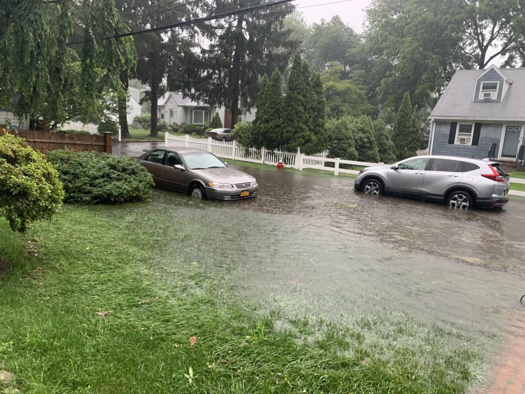
Many North Shore residents spent their Thursday cleaning up after remnants of Tropical Depression Ida pummeled the Island Wednesday night. In addition to the storm, the National Weather Service issued a tornado warning for the North Shore of Suffolk County.

According to PSEG Long Island, the hardest-hit areas on the Island include Northport, Ridge, Lloyd Harbor and Huntington.

Huntington

In the Town of Huntington, flooding outside of the Huntington Sewage Treatment Plant on Creek Road left several motorists stranded, according to a press release from the town. STP staff accessed the facility via payloader late in the evening on Sept.1. During the peak of high tide, STP staff were unable to access the plant from the main entrance on Creek Road or from the rear entrance near the Mill Dam gates.

 “We actually had to take a payloader out to the Creek Road entrance to bring one of our employees into the plant last night,” said John Clark, the town’s director of Environmental Waste Management. “Several cars, including a police vehicle, were stuck on Creek Road and New York Avenue — at least one driver (a police officer) had to be removed via boat by the Huntington Fire Department.”  

Steve Jappell, a wastewater treatment plant operator at the STP facility, operated the payloader and assisted fellow employee Joe Lombardo and the police officer, who was ultimately transported from the scene by the Huntington Fire Department in a rescue boat. 

“Thank you to the Huntington Fire Department, as well as Centerport, Halesite and Northport fire departments, who also arrived to assist other stranded motorists on Creek Road, and to our quick-thinking staff at the plant,” said town Supervisor Chad Lupinacci (R).

According to the press release, the area received its largest rain event in nearly 20 years between 7 p.m. and 1:30 a.m. The town reported that 6.29 inches fell during the 6 ½ hours.

While the STP usually processes around 1.8 million gallons per day, between 6 a.m. Sept. 1 and 6 a.m. Sept. 2 it processed more than 3.8 million gallons. According to the town, the plane “will continue to experience above average flow rates over the next two days as groundwater intrusion and sump pump activity contribute to the increased volumes.” 

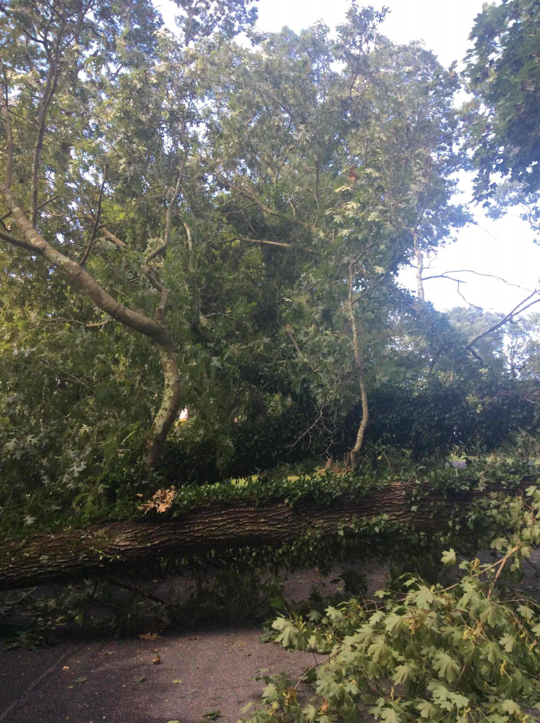
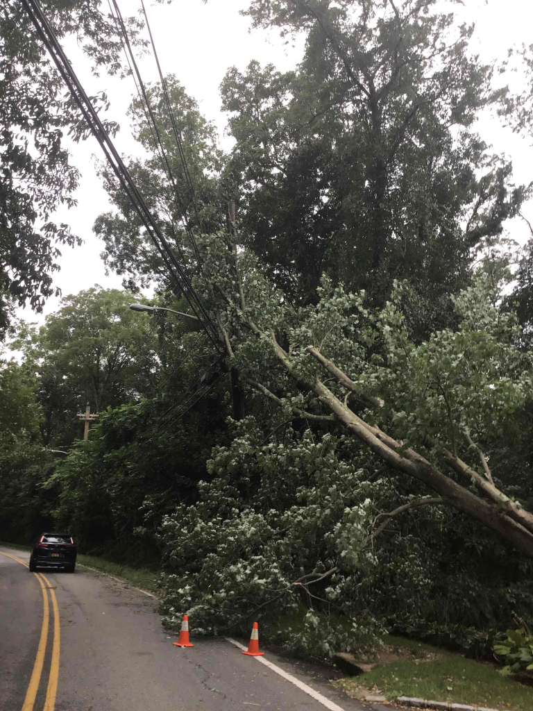
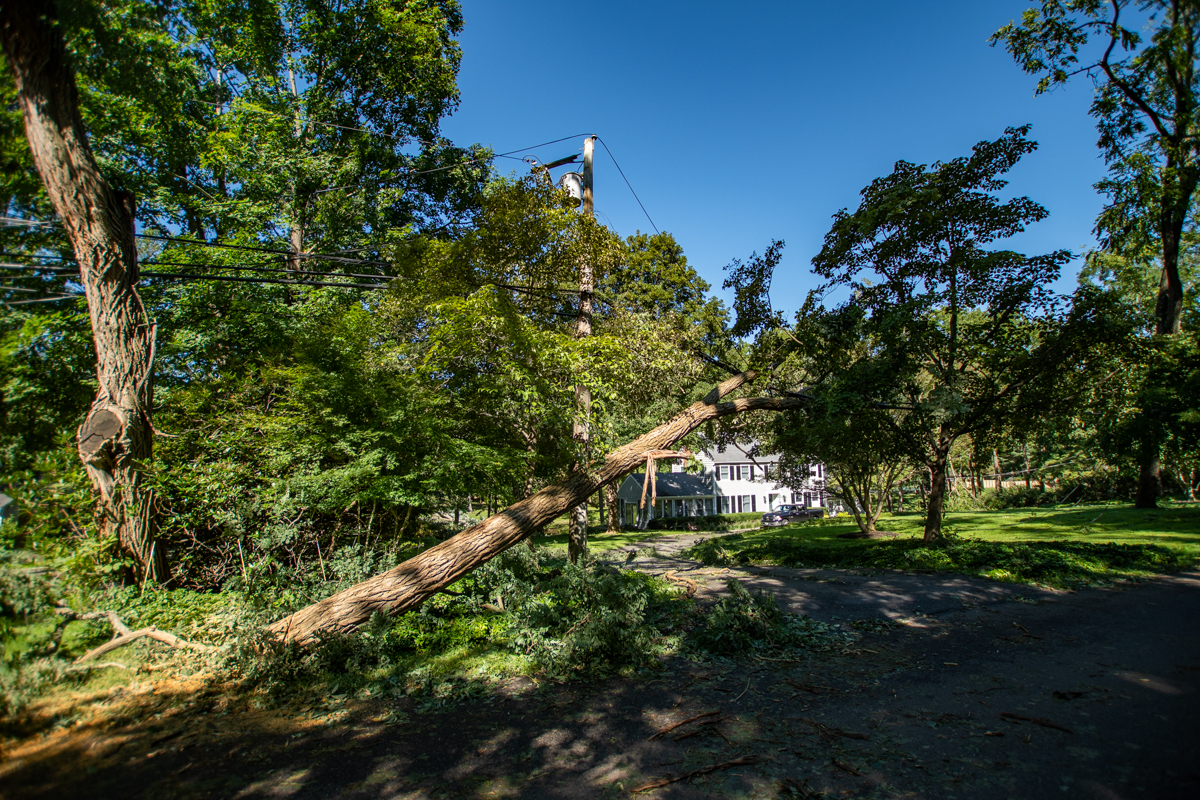
Town officials also said there were 26 reports of flooding mostly in Huntington; 29 reports of downed trees and branches; 16 reports of large pieces, sections and layers of asphalt ripped away, five manhole covers washed aside and one possible sinkhole was reported in Northport as asphalt washed away on Oleander Drive.

As for town facilities both golf courses had some flooding and were closed Sept. 2, and Town Hall had about ½ inch of flooding in the basement.

Smithtown

According to Smithtown Public Information Officer Nicole Gargiulo, there was flooding in the Smithtown Town Hall basement; however, there was no other damage to equipment or facilities in the town.

During the peak of the storm, the town received calls about flooded roads, but the streets were cleared as of the morning of Sept. 2. 

Callahan’s Beach sustained damage, according to Gargiulo. The beach had already been closed due to damage after a storm in the early morning hours of Aug. 27. 

Stony Brook University

Students in the Mendelsohn Community of Stony Brook University, which is located on the North end of campus off of Stadium Drive, were the SBU students most affected by the storm. According to communications sent out by the university, while other areas of the campus experienced flooding conditions, Mendelsohn was the most affected and students needed to be relocated.

Also affected by the storm was the Student Brook Union, and the building is closed for damage assessment and cleanup. The university held a ribbon cutting ceremony for the newly renovated student union building last week. Employees who work in the building were asked to work remotely Sept. 2.

In an email from Rick Gatteau, vice president for Students Affairs, and Catherine-Mary Rivera, assistant vice president for Campus Residences, “the Mendelsohn buildings have no power due to 4-6 feet of water in the basement, resulting in a power failure to the building.  At this time, it is unsafe to be in the building while our teams pump out the water, assess the damage, and determine the timeline for repairs.”

Mendelsohn residents were not required to attend class on Sept. 2.
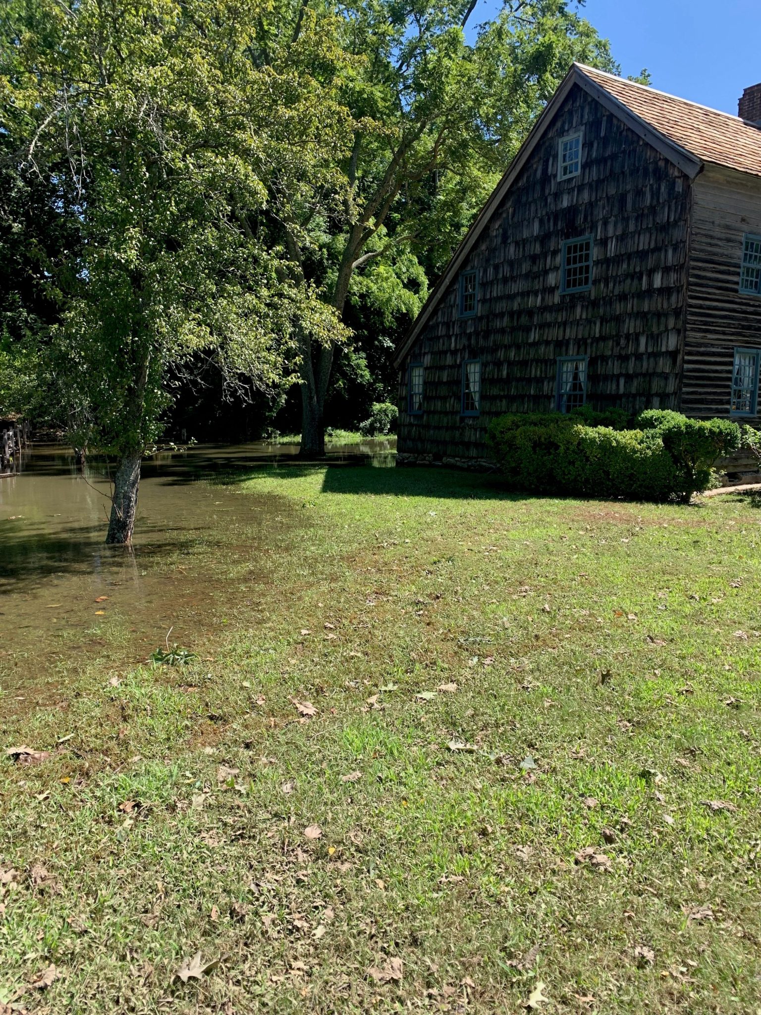
Three Village 

During the storm, the historic Thompson House in East Setauket took in 33 inches of water in its basement. Some of the water rose up to the first floor of the 1709 structure.

The building, which belongs to the Ward Melville Heritage Organization, will need to have the water pumped out, according to WMHO President Gloria Rocchio. After the water is pumped out, a cleanup company will have more work ahead of them to prevent any more damage.

According to the National Weather Service, 6.86 inches of rain fell in Setauket. The NWS reported that it was the highest rainfall total on Long Island.

Additional reporting by Daniel Dunaief.

PSEG Long Island continues to monitor the impending storm. Tropical Storm Henri is intensifying to a Category 1 hurricane as it continues up the coast to Long Island.  As of 8 a.m. today, the weather system is forecasted to bring heavy rains and high winds with peak gusts ranging from 30 to 35 mph in western areas and 50 to 65 mph on the east end of Long Island beginning Sunday morning. Given the potential intensity of the storm, some outages may last up to seven to 10 days. The eastern end of Long Island is expected to experience the most severe weather and impact.

PSEG Long Island is performing system checks and ensuring extra supplies are on hand, including poles and transformers preparing for potential outages.

“We continue to monitor the track of Tropical Storm Henri,” said Michael Sullivan, senior director of Transmission & Distribution at PSEG Long Island. “As the storm makes its way up the coast, employees are preparing for the possibility of high winds that can cause flying debris, and bring down trees and power lines. We encourage our customers to do the same at their homes and businesses.”

PSEG Long Island has personnel ready to respond safely and as quickly as possible throughout the storm. Additionally, more than 1,200 line workers, tree trimmers, surveyors and other utility personnel from both local and off-Island resources are being procured to work alongside PSEG Long Island’s highly trained line personnel.

In addition to having additional personnel and equipment at the ready, PSEG Long Island has strengthened the electric grid to better withstand extreme weather and allow for faster power restoration, including elevating a number of substations above flood level in preparation for this kind of severe weather.

PSEG Long Island’s employees have been working continuously for the past seven years to make the electric infrastructure more resilient to extreme weather. From storm hardening upgrades to ongoing enhanced tree maintenance, the company’s proactive work allows the system to better withstand extreme weather.

COVID-19-related storm processes have been adjusted to continue to keep the health and safety of employees and customers at the forefront, even during these unusual times.

As part of their physical distancing protocols, they ask that customers remain in their homes when crews are working nearby. If customers must speak with the crews, they ask that they practice responsible physical distancing and remain at least 6 feet away to ensure the health of everyone involved. For more information about how PSEG Long Island continues to live up to its commitments during the pandemic, please visit www.psegliny.com/covid19.

During this storm, if necessary, PSEG Long Island may use an enhancement to our outage communications process. With this enhancement, customers contacting the Call Center early in the storm will receive a message that personnel are assessing conditions, rather than an estimated time of restoration (ETR). This change will allow crews to assess storm impact before issuing ETRs, thereby increasing the accuracy of the ETR information being provided. For more information about this new process visit https://www.psegliny.com/outages/estimatedrestorationtimes.

Customers should prepare, be cautious and stay alert to their surroundings during and after storms. Review storm preparation tips at https://www.psegliny.com/safetyandreliability/stormsafety.


Stay connected:

  • Download the PSEG Long Island mobile app to report an outage and receive information on restoration times, crew locations and more.
  • To report and receive status updates via text, text OUT to PSEGLI (773454) or visit us online at www.psegliny.com/outages
  • To report an outage or downed wire call PSEG Long Island’s 24-hour Electric Service number: 800-490-0075.
  • Follow PSEG Long Island on Facebook and Twitter to report an outage and for updates before, during and after the storm
  • View PSEG Long Island’s outage information across Long Island and the Rockaways online at https://mypowermap.psegliny.com

METRO photo

In order to ensure sufficient electrical supply at a time of sustained extreme heat and humidity and the successive failures of third-party owned supply systems, PSEG Long Island is following established procedures to address resource capacity concerns. Based on current system conditions, PSEGLong Island is now urging all customers on Long Island and in the Rockaways to reduce electric use as much as possible during the peak hours of 3 and 7 p.m. today.

In addition to the typical demand challenges faced during high heat, PSEG Long Island has been working with the third-party owners of two interconnections that provide electricity to the service area and currently require repairs.

While PSEG Long Island has taken emergency measures to bring additional capacity online and will continue to implement available options in accordance with established contingency plans, today’s peak demand is at risk of exceeding the available energy supply. Reductions in customer energy use are also required to reduce demand.

PSEG Long Island urges customers to:

  • Eliminate ALL nonessential electric use.
  • Run air conditioners only if needed for health reasons.
  • Use fans instead of air conditioners when possible.
  • If air conditioning is needed, set home thermostats or air conditioner units to 78 degrees.
  • Only run nonessential home appliances such as washing machines, dishwashers and pool pumps in the morning or late evening to avoid the peak demand hours of 3 p.m. to 7 p.m.
  • Do not cool an empty house. Set your thermostat higher when you are away, or use a smart thermostat to control the temperature in your home. Customers can receive an incentive on qualifying thermostats for enrolling in PSEG Long Island’s Smart Savers Thermostat program, which can be used to control usage during peak summer days. Visit https://www.psegliny.com/smartsavers for more details.
  • Commercial customers may sign up for the Commercial System Relief program. Visit https://www.psegliny.com/contactus/businessandcommercialsavings/csrp for more details.
  • Close blinds and draperies facing the sun to keep out the sun’s heat.
  • Set your ceiling fan to spin quickly, counterclockwise to push air downward toward the floor
  • Businesses should reduce lighting use to a minimum
  • Commercial buildings should set air conditioners to maximum efficiency and raise the thermostat setting

PSEG Long Island will also ask its Major Accounts customers, the largest in the service area, to voluntarily curtail their electric consumption.

Customers participating in the Direct Load Control – Smart Savers Thermostat Program will have their temperature increased by 4 degrees on home central air conditioning units via the internet between the hours of 3 and 7 p.m. today. Approximately 31,000 PSEG Long Island customers island-wide participate in Smart Savers. Commercial customers participating in Demand Response programs will receive financial incentives for committing to reduce their electric use during peak periods. Activating these programs can save about 45 MWs of electrical demand.

Long Island and the Rockaways may also experience outages due to excessive heat and the potential loss of supply. PSEG Long Island has mobilized extra repair crews, who are working 16-hour shifts around the clock to restore outages safely and as quickly as possible. Customers who experience an outage should call 1-800-490-0075.

State, city, and county emergency management authorities, and local elected officials have been notified by PSEG Long Island.

The safety of PSEG Long Island’s customers and employees is the company’s top priority.

PSEG Long Island wants to make sure customers who rely on electric life support equipment are aware of this event so that they can make arrangements in case they do lose power. PSEG Long Island urges customers to be prepared and to stay safe during this event. In the event of a medical emergency please call 911.

During extreme heat conditions, PSEG Long Island encourages all customers to:

  • Seek out air-conditioned spaces (if safe) if their homes become too warm.
  • Stay hydrated by drinking plenty of water. Avoid drinks with caffeine or alcohol.
  • Avoid wearing dark colors because they absorb the sun’s rays.
  • Never leave children or pets alone in enclosed vehicles.
  • Avoid strenuous exercise during the hottest part of the day, which is between 10 a.m. and 2 p.m.

Visit PSEG Long Island at:  www.psegliny.com

Photo from Pixabay

Looking out the window on a sunny day, one might notice a not-so-subtle haziness in the sky. However, that haze isn’t harmless clouds or fog, it’s smoke that’s traveled a far distance across the nation from raging wildfires in California and Canada.

As concerns grow over the impact of these wildfires stretching their way over to the East Coast, Long Islanders are beginning to become uneasy about the repercussions the hazy smoke might have among residents. 

With multiple reports of poor air quality in the past few weeks, people who have vulnerable conditions such as asthma, emphysema, or heart disease need to be wary and avoid going outside or doing strenuous activity. 

“There is something called fine particulate matter, which is very small ash,” said Adrienne Esposito, executive director of Citizens Campaign for the Environment. “The cause of concern is that this is the type of material that causes respiratory ailments. It irritates the throat and respiratory system, but most importantly fine particulate matter can lodge in your lungs and make microscopic perforations, much like asbestos.”

According to Esposito, It is highly likely the ash will also be deposited into Long Island’s estuary and could affect the marine environment. However, it is uncertain exactly how much will accumulate due to the variables of wind speed and the amount of ash that will be pushed toward the Island. 

“The East Coast should absolutely have an increased concern of weather events associated with climate change,” she added. “What we are having right now is an increase of torrential rain, and an increase in intensification of storms which means that hurricanes that might normally be a Category 1 [the lowest] now have the ability to reach 2, 3, or 4.” Esposito said. 

Kevin Reed. Photo from Stony Brook University

Although air pollution issues are nothing new to New York, there are always certain times of the year, particularly in the summertime, that fine particulate matter can get trapped. The question of the future frequency of surrounding wildfires still stands.

While Long Island is experiencing a rainy season, California is currently facing one of the worst droughts in history. Within a two-year period, rain and snow totals in parts of the West have been 50 percent less than average.  

“Just because Long Island is having a really wet season right now doesn’t mean it couldn’t shift later this year,” said Kevin Reed, a Stony Brook University School of Marine and Atmospheric Sciences researcher. 

According to Reed, the winds that blow from out West don’t always streamline toward the East Coast. Direction in wind patterns could cause the air flow to “wobble,” so it is uncertain whether or not Long Island may face more smoke pollution in the future. 

“Drought is certainly becoming more severe, potentially longer lasting, and at a larger extent, which means larger parts of land will be susceptible to wildfire,” Reed said.

Adding that wildfires are typically a natural occurrence and benefits land by replenishing it, Reed said the extent of the current wildfires is most likely a result of climate change and has potential to harm people and the environment.

“Air pollution could really affect our human health, especially to certain groups that are more susceptible to issues with air quality,” he said. “Even if it’s here for one day it could have an impact and of course the impact is going to be multiplied if it’s a longer-term event.” 

Image from PSEG

With Long Island and the entire New York City metropolitan area expecting high temperatures and humidity for the next few days, PSEG Long Island asks its customers to voluntarily conserve electricity when possible.

In addition to the typical demand challenges faced during high heat, PSEG Long Island is aware of issues affecting some interconnections that provide electricity to the service area and is working with their third party owners. We have set in place proactive measures to address energy demands across Long Island and the Rockaways. PSEG Long Island expects to have sufficient electricity from available sources to meet forecasted customer demand, contingent upon other transmission and generation facilities remaining in service. To ensure the demand does not exceed forecasts, customers in Nassau and Suffolk counties and the Rockaways are asked to use electricity wisely.

As the heat arrives, PSEG Long Island may choose to activate its voluntary Smart Savers Thermostat program to reduce loading on the system and create future savings for customers. Approximately 31,000 customers have voluntarily enrolled in this program.

“With more people working from home, it’s more important than ever that we all do our part to conserve energy and reduce overall peak demand,” said Michael Sullivan, senior director of Transmission and Distribution, PSEG Long Island. “PSEG Long Island has made preparations for this situation and our personnel will work according to plan to provide the electricity we all need. By working together, we can avoid exceeding load forecasts and ensure that everyone’s air conditioning stays on as we weather this heat.”

PSEG Long Island also encourages customers to take these easy and practical energy conservation measures that can reduce peak demand on the system and save them money.

  • Set home thermostats or air conditioner units to 78 degrees.
  • Run major appliances such as washing machines, dishwashers and pool pumps, in the morning or late evening to avoid the peak demand hours of 2 p.m. to 8 p.m.
  • Set refrigerators and freezers at most-efficient temperatures.
  • Do not cool an empty house. Set your thermostat higher when you are away, or use a smart thermostat to control the temperature in your home. Customers can receive an incentive on qualifying thermostats for enrolling in PSEG Long Island’s Smart Savers Thermostat program, which can be used to control usage during peak summer days. Visit https://www.psegliny.com/smartsavers for more details.
  • Commercial customers may sign up for the Commercial System Relief program. Visit https://www.psegliny.com/contactus/businessandcommercialsavings/csrp for more details.
  • Close blinds and draperies facing the sun to keep out the sun’s heat.
  • Ceiling fans cool fast and cost less than air conditioning. (In hot weather, set your ceiling fan to spin quickly, counterclockwise to push air downward toward the floor.)
  • Seal holes and cracks around doors and windows with caulk or weather-stripping.
  • Replace old appliances with new energy efficient ENERGY STAR® appliances
  • Replace air filters monthly. Dirty filters make your air conditioner work harder.

Additional energy saving conservation tips can be obtained from PSEG Long Island’s website, www.psegliny.com, or by calling its Energy Infoline at 1-800-692-2626.

Stock photo
Leg. Nick Caracappa

The 2021 Atlantic hurricane season officially began on June 1, and will end on November 30. Suffolk County Legislator Nick Caracappa would like to encourage residents to be prepared. “Most of this past year’s focus has been on the Coronavirus pandemic, but we must still remember that the hurricane season is upon us.  It is important to be aware and prepared,” stated Legislator Caracappa. “Let’s all be prepared for the worst, and hope for the best.”

The following tips are provided by ready.gov/hurricanes. Please visit the site below for a comprehensive list of suggestions for before, during, and after a hurricane or tropical storm: https://www.ready.gov/hurricanes#before

Know your Hurricane Risk

Hurricanes are not just a coastal problem. Find out how rain, wind, water, even tornadoes could happen far inland from where a hurricane or tropical storm makes landfall. Start preparing now.

Make an Emergency Plan

Make sure everyone in your household knows and understands your hurricane plan. In your hurricane plans include the office, kids’ daycare, and anywhere you frequent. Ensure your business has a continuity plan to continue operating when disaster strikes.

Discuss the latest Centers for Disease Control (CDC) guidance on Coronavirus (COVID-19) and how it may affect your hurricane planning.

Know your Evacuation Zone

You may have to evacuate quickly due to a hurricane if you live in an evacuation zone. Learn your evacuation routes, practice with household, pets, and identify where you will stay.

  • Follow the instructions from local emergency managers, who work closely with state, local, tribal, and territorial agencies and partners. They will provide the latest recommendations based on the threat to your community and appropriate safety measures.

Recognize Warnings and Alerts

Have several ways to receive alerts. Download the FEMA app and receive real-time alerts from the National Weather Service for up to five locations nationwide. Sign up for community alerts in your area and be aware of the Emergency Alert System (EAS) and Wireless Emergency Alert (WEA)- which requires no-sign up.

Those with Disabilities

If you or anyone in your household is an individual with a disability identify if you may need additional help during an emergency.

Review Important Documents

Make sure your insurance policies and personal documents like ID are up to date. Make copies and keep them in a secure password protected digital space.

Strengthen your Home

De-clutter drains and gutters, bring in outside furniture; consider hurricane shutters.

Get Tech Ready

Keep your cell phone charged when you know a hurricane is in the forecast and purchase backup charging devices to power electronics.

Help your Neighborhood

Check with neighbors, senior adults, or those who may need additional help securing hurricane plans to see how you can be of assistance to others

Gather Supplies

Have enough supplies for your household, include medication, disinfectant supplies, masks, and pet supplies in your go bag or car trunk. After a hurricane, you may not have access to these supplies for days or even weeks.

  • Remember that not everyone can afford to respond by stocking up on necessities. For those who can afford it, making essential purchases and slowly building up supplies in advance will allow for longer time periods between shopping trips. This helps to protect those who are unable to procure essentials beforehand and must shop more frequently. Only take the items you and your family may need so that others who rely on these products can also access them.

Have a great summer, and stay safe!