Striving to be more environmentally conscious, the Greater Port Jefferson Chamber of Commerce invites the community to join them on Saturday, June 17, for its 9th annual Green Fest. This festival will draw in hundreds from all over Long Island who want to become more environmentally conscious.
Held at the Port Jefferson Village Center at 101A East Broadway and the neighboring Mayor Jeanne Garant Harborfront Park’s Great Lawn from 1 to 5 p.m., this thematic event reflects a world that gives you the ability to make “green” choices in your daily lives. The festival concentrates on educating, informing, entertaining and enlightening people on how to live a “greener” lifestyle.
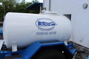
This year come check out the “water buffalo” sponsored by the Suffolk County Water Authority. This portable water truck will be filled with hundreds of gallons of water for all attendees to fill up their own water bottles with fresh clean water. This helps the environment by reducing plastic bottles going into our landfills. So bring your containers and have a drink on us!
Entertainment will again be engaging and fun this year. The Ripple Effect Spiritual Therapy Drum Circle will be bringing 13 drums with shakers and rattles to compliment the other percussions. These hand drums are placed in a circle and volunteers are asked to “perform” in an improvisational manner as a gathered group. Drop-ins are welcomed, so come and play with us.
At 1 p.m. the local and very popular singer/songwriters, the Como Brothers, will be performing their heartfelt lyrics and harmonies on the Great Lawn. Their style of songwriting draws from pop, rock and blues originating from a love for acts such as the Beatles.
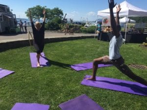
If you are not feeling musical, join It Takes a Village Wellness yoga instructor and owner Diane McDonald at 2 and 2:40 p.m. for some green yoga right on the front lawn of the PJ Village Center; mats will be provided.
Join the Port Jefferson Free Library’s Green Teens throughout the day for children’s activities as the group presents a short demonstration on how to create crafts using recycled materials while also teaching others what it means to be a Green Teen at the Port Jefferson Library.
“Your Connection to Nature” biologist, wildlife handler, outdoor educator, photographer, traveler and storyteller Ranger Eric Powers will present two programs reflecting wild diversity using live animals! Just in case you want more animals, check out the Sweetbriar Nature Center’s table to visit with its resident screech owl.
Finally, to keep attendees amazed, there will be varied vendors (see page B18) highlighting green products and services including solar power and renewable energy, electric/hybrid cars, demonstrations and a mini-farmers market.
This free event is family friendly and kicks off the summer season. Come on down and enjoy the day, learning about methods that promote sustainable ways of living that benefit our environment and planet. Won’t you join forces with us to work together to make our community a healthier place to live? It starts with one small step (or fest) at a time.
For more information, visit www.portjeffgreenfest.com or call the chamber at 631-473-1414.