A small taste of history: Middle Country and Horseblock Roads
")
Amongst the Middle Country Public Library’s many historical artifacts are a few that explain just how far the area has come from its pastoral roots. The picture and story below comes courtesy of a collaborative effort among the librarian staff.
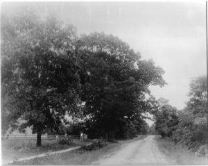
Driving along Middle Country Road today, it is hard to imagine that only 100 years ago, this busy four- lane highway with its many intersections, signs, and streetlights started out as little more than a hard-packed dirt road.
Go back 100 years more, and you’d only see a narrower, rutted path. We take our nicely maintained, hard paved roads for granted today, but it wasn’t always such a smooth ride.
Today’s network of streets and highways have their origins in simple trails which were used by people and wildlife leading to sources of water and shelter.
These paths measured only two to three-feet wide in places, but they were sufficient for the needs of the times.
Early English settlers began to use these footpaths as they established homesteads on Long Island, widening and improving these paths, using them as cart-ways to allow for easier travel between their farms. The cart-way needed to be wide enough for a livestock-drawn cart to traverse with ease. In those days a cart would be hauled by cattle, ox, or horsepower.
Those paths were the only way to travel around Long Island until 1703, when the NY General Assembly appointed highway commissioners in King’s County (Brooklyn), Queens County and Suffolk County to direct the building and maintenance of roads “four rods wide.” The roads were simply packed earth, hardened over time by travelers. It took some time for conditions to improve, and eventually drainage systems were constructed, and logs or planks were laid across some roads to pave them. These log-covered roads were known as “corduroy roads” because of their bumpy surface.
Thirty years after the highway commissions laid out the routes, arranged rights-of-way between existing properties and physical construction took place, Long Island boasted three major thoroughfares: North Country Road, parts of which follow today’s Route 25A; Middle Country Road, now known as Route 25 or Jericho Turnpike; and South Country Road, portions of which serve as Montauk Highway.
An organized system of roads was needed for many reasons as the population grew. Though most homesteads were self-sufficient at that time, people would barter for goods and gather together to socialize. Mail needed to be delivered across the Island, and prior to the establishment of the U.S. Postal Service in 1775, England’s Royal Mail System was utilized. Before reliably passable roads were built, that mail was delivered from Connecticut by boat. It was faster and easier to travel 19 miles by water than 120 miles overland from New York City.
As the farmland was cultivated and enriched over time, it produced more than one family or village could use and farming became a burgeoning industry.
Means to transport the surplus produce was required. Farm to Market Road (also called Horseblock Road) filled this need. Farm owners would load their wagons full of fruits and vegetables to ship by rail to New York City.
The term “horseblock” refers to a block of stone or wood used to help a person climb high enough to mount a horse or to enter a stagecoach with ease. With many homes, farms and taverns located along these miles of roadway, horseblocks were a familiar sight. We call this same Farm to Market Road by its old nickname, Horseblock Road to this day.
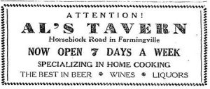
Through the years, several popular taverns and rest stops were located on Horseblock Road. As far back as Revolutionary times, Sam “Horseblock” Smith owned and ran a tavern at the intersection of Horseblock and Middle Country Roads in Centereach.
A Smith genealogy relates that on March 2, 1806 Sam sold the inn and land to Lake Grove resident, Titus Gould. It appears that part of the tavern was dismantled and moved to another location. Generations later, Alfred Elsmann ran Al’s Tavern, at the corner of Horseblock and Granny Roads. It was advertised in the Patchogue Advance of March 7, 1946 as specializing in home cooking and “the best in beer, wines and liquors,” and was a popular destination for local festivities for several decades.


