A horrific crash on the Southern State Parkway injured many Huntington High School students when a coach bus slammed into an overpass April 9. The accident could have been easily avoided, elected officials said, and we couldn’t agree more.
While we cannot control human error, this should be a wake-up call to re-examine our use of technological safety devices.
U.S. Sen. Chuck Schumer (D-NY) said he called for improved transportation safety measures at the very same place, Exit 18 at the Eagle Avenue bridge, where an accident occurred in 2012. As a result, the Federal Motor Carrier Safety Administration advised truck drivers and commercial vehicles that a new GPS system was available to warn of parkways and roadways along their route with low clearances.
While installing this commercial GPS system into commercial vehicles was highly recommended, Schumer admitted it was not mandated by federal law. Elected officials presumed transportation companies would voluntarily shell out money to improve safety. Decisions regarding passenger safety should not be left in the hands of private corporations. Federal, state and county politicians need to reconsider legislation that would require this vital, potentially life-saving equipment on school buses, coach buses, RVs and other tall passenger vehicles.
This accident also warrants taking a closer look at those new technologies in the process of being installed on Long Island’s parkways. Gov. Andrew Cuomo (D) announced Dec. 5 of last year that $4.3 million in funds would be spent to install overheight vehicle detectors at 13 locations in Nassau and Suffolk counties. His goal was to use state-of-the-art technology to prevent bridge strikes that can be potentially fatal and snarl traffic for hours.
These detectors are installed at the top of on-ramps and relay an invisible beam set at the specific height needed to clear the parkway’s bridges. If a vehicle breaks the beam, the device triggers a colored LED message sign to flash a warning to the driver, alerting the truck or bus will not clear the bridge.
Joe Morrissey, spokesman for the New York State Department of Transportation, confirmed these detectors have been installed at the Eagle Avenue overpass, but said they are not yet active due to calibration and testing. Morrissey admitted even if the detectors had been functioning, they would not have prevented the accident. They are not set up to scan for overheight vehicles entering from the Belt Parkway, as the coach bus did.
Elected politicians and transportation officials made the assumption that because buses and commercial vehicles are not allowed on the Belt Parkway, none would enter the Southern State Parkway from that ramp.
Cuomo’s plan to install these vehicle detectors needs to be looked over again to better determine where sensors need to be placed. Additional measures, like notification to highway police when the sensor is set off, should also be considered.
These oversights are putting holes in the safety net.
The intersection of Barnum Avenue and West Broadway in Port Jeff Village now features left and right green arrows. Photo by Alex Petroski
Changes have finally been made to a Port Jefferson Village intersection closely situated near the Town of Brookhaven boat launch ramp within the Port Jefferson Marina.
The New York State Department of Transportation installed new traffic signals at the intersection of Barnum Avenue and West Broadway Dec. 12 in the hopes of further alerting northbound drivers on Barnum not to proceed through the intersection, as just yards away on the other side lies the boat ramp directly into Port Jefferson Harbor. The new signal features green left and right arrows, replacing the standard green signals that used to hang above the crossing.
The change was made after a letter was sent to the department by Village Mayor Margot Garant earlier this year calling for safety improvements in the aftermath of an April 6 incident in which a man in his early 60s drove into the harbor via the same boat launch. DOT Regional Director Joseph Brown responded to Garant in a letter dated Sept. 15, saying the department had conducted an investigation which included an accident analysis, turning movement counts, pedestrian counts and field observations of the area. The letter also said the DOT would heed Garant’s request and change the traffic light.
On Oct. 30, 69-year-old Lake Grove resident William Whalen was pronounced dead at the hospital after he was pulled from a submerged vehicle in Port Jefferson Harbor. His vehicle entered the water via the troublesome intersection.
“I think it’s one of many steps we’re going to continue to take,” Garant said of the new traffic signals during a Dec. 18 board meeting. “For those who are paying attention the green arrows help, but I think clearly for those people who are having either a medical problem or maybe an ulterior motive, they might just continue to drive through. I don’t really know.”
Garant said the village’s only recourse at the intersection is to add more signage, which she said the village would pursue, as West Broadway is a New York State road, and Brookhaven owns the boat ramp and marina. A spokesperson from the town declined to comment and instead directed inquiries to the office of Councilwoman Valerie Cartright (D-Port Jefferson Station)regarding additional plans to prevent drivers from entering the harbor. Cartright’s office declined a request for comment.
Michael Schwarting and Frances Campani, of Campani and Schwarting Architects in Port Jefferson, in a joint letter to the editor and in a presentation to the village said they thought the new signals might not be enough. The architects suggested the exit from the ramp could be narrowed so that it does not perfectly align with the intersection.
“Narrowing the exit from the ramp so that it does not align with the Barnum lane running north would make it almost impossible to turn in,” the letter said. “It is pedestrian friendly, would not be very expensive and would add to the visual quality of the intersection.”
Village Deputy Mayor and Trustee Larry LaPointe said during the meeting he liked the architects’ idea.
“I thought that was a very good design,” he said. “I’d like to see the town consider that.”
In December 2005 60-year-old Setauket resident Richard Levin drove into the water on the same ramp and onlookers had to pull his unconscious body from the fully submerged car. Levin died days later as a result of the incident. The wife and executrix of the estate of Richard Levin named the town and village as co-defendants in a lawsuit in 2007. A New York State Supreme Court judge ultimately dismissed the case in 2011, finding the municipalities were not at fault.
A motorist driving an SUV died after being pulled from his vehicle in Port Jefferson Harbor Oct. 30. Photo by Dennis Whittam
A man was pronounced dead at St. Charles Hospital in Port Jefferson after he was pulled from a submerged vehicle in Port Jefferson Harbor just after 7 p.m. Oct. 30, according to Suffolk County Police Department Assistant Commissioner Justin Meyers. Police have identified the man as William Whalen, 69, of Lake Grove.
“A 911 call came in at 7:10 p.m. after witnesses observed a car drive into the water at the Port Jefferson Marina boat launch located off of West Broadway Avenue and Barnum Avenue in Port Jefferson Village,” Meyers statement said. “Sixth Precinct Officers Brian Christopher and Michael Cappelli responded and jumped into the water and extricated a male victim that was trapped in his vehicle which was completely submerged. Personnel from the Port Jefferson Village Fire Department and Setauket Fire Department also responded and also went into the water to help extricate the victim.”
A motorist driving an SUV died after being pulled from his vehicle in Port Jefferson Harbor Oct. 30. Photo by Dennis Whittam
The officers were being treated for hypothermia in the aftermath of the incident.
Members of the Port Jefferson Fire Department — Lieutenant Geoffrey Markson, Ex-Captain David Okst and First Assistant Brennan Holmes — were on the eastern end of the marina parking lot working on the department’s fire boat when they were alerted of the incident on their paging devices, according to a spokesperson from the PJFD chief’s office. The three jumped into the water, eventually breaking the window with a hammer and removing the seatbelt to pull the victim from the car. Two PJFD Heavy Rescue Squad members in diving gear also arrived on the scene to assist in the rescue effort.
“We had a brief conversation that went, ‘are we doing this? Yeah we’re doing it,'” Holmes said during a phone interview.
He said the three firefighters were focused only on action and not on what might happen to them if they jumped in the water.
“We could have saved a life,” Port Jefferson Village Mayor Margot Garant said via email Monday night.
Garant announced during a board meeting June 5 the village had sent a letter to the New York State Department of Transportation and State Sen. Ken LaValle (R-Port Jefferson) asking for the traffic signal at the intersection of Barnum Avenue and West Broadway to be changed from having a standard green light to a green left arrow and right arrow. The call was in response to an April 6 incident in which a man in his early 60s drove into the harbor via the same boat launch. Four good Samaritans rescued that driver, and were later honored by the Port Jeff Village board in July. Garant said the DOT told her in a letter she received about five weeks ago they intended to comply with her request to change the light.
“I am thankful that the DOT was willing to entertain and adopt our suggestion, and when the light is changed, it may save a life,” Garant said Tuesday.
In December 2005 60-year-old Setauket resident Richard Levin drove into the water on the same ramp and onlookers had to pull his unconscious body from the fully submerged car. Levin died days later as a result of the incident.
According to documents obtained from Brookhaven in May, both Brookhaven Town and Port Jeff Village were sued by the wife and executrix of the estate of Richard Levin in 2007.
“As a result of the negligence of the defendants in failing to properly maintain the intersection of Route 25A and Barnum Ave., in failing to properly safeguard against motorists driving onto said Port Jefferson ramp into the water, in failing to properly illuminate said area, in failing to provide fencing and warning lights — as a result of the aforementioned Richard Levin died,” the lawsuit read in part. “[The] town failed to submit any evidence that it maintained its property in a reasonably safe condition by providing adequate fencing, lighting or warning of the dangerous condition on its property.”
“We had a brief conversation that went, ‘are we doing this? Yeah we’re doing it.'”
— Brennan Holmes
Judge Joseph Farneti of the New York State Supreme Court dismissed the lawsuit in January 2011 because the “acts or omissions of defendants were not the proximate cause of the alleged accident.”
The April incident stirred up memories more than a decade old for one former village resident.
“People are dying here and it’s a simple fix,” Christopher Kelsch, one of the people who witnessed Levin’s death 12 years ago and tried to help, said shortly after seeing news of the April incident. “Somebody needs to shine a serious spotlight because Dr. Levin died at that location.”
Following the April incident, a Brookhaven Town spokesperson said in a statement there are clear signs and traffic measures in place to warn residents of the ramp’s location.
“The Port Jefferson boat ramp has existed at its current location for generations,” the spokesperson said. “A number of measures are in place including a multitude of ‘Do Not Enter’ signs, road arrows and other traffic control measures to clearly indicate that this is not an entrance.”
A Brookhaven Town spokesperson directed questions to the police department Monday night. Garant called on the town to take action in April, as the marina is town-owned property.
A spokesperson for Lavalle said the state senator was meeting with representatives from the DOT Nov. 1 to discuss the incident and troublesome intersection.
This post was updated Oct. 31 to include information from the PJFD Chief’s office and a quote from Brennan Holmes, and Nov. 1 to include a response from Ken Lavalle’s spokesperson.
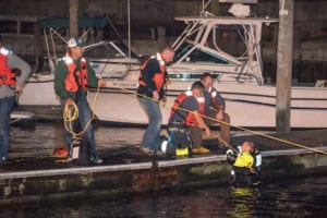
Good Samaritans and SCPD Marine Bureau divers help a driver submerged in
Port Jefferson Harbor April 6. Photo by Andrew Tetreault/Fully Involved Media Group
Following an April incident in which a man drove into Port Jefferson Harbor via the Town of Brookhaven boat ramp located at the north end of Barnum Avenue, Port Jefferson Village is calling for action.
Village Mayor Margot Garant announced during a board meeting June 5 the village has sent a letter to the New York State Department of Transportation and State Sen. Ken LaValle (R-Port Jefferson) asking for the traffic signal at the intersection of Barnum Avenue and West Broadway to be changed from having a standard green light to a green left arrow and right arrow. The April 6 incident saw a man in his early 60s drive into Port Jefferson Harbor via the ramp at about 5:30 p.m., according to the Suffolk County Police Department. The car was found submerged underwater and a few good Samaritans helped remove the man from the car. Members from the Suffolk County Marine Bureau dive team went in the water to search for possible additional victims. The driver was treated for serious injuries at Stony Brook Hospital and his current condition is still not known, according to Garant.
“People sometimes are losing their way on a misty morning or a foggy morning or a rainy morning or on a sunny morning,” Garant said during the meeting.
In the aftermath of the incident in April Garant called on the Town of Brookhaven to step up and do something to resolve the recurring issue, as the ramp is town property.
“It’s only a matter of time before this happens again,” she said.
A spokesperson for the town that asked not to be named responded to Garant’s calls for action at the time.
“The Port Jefferson boat ramp has existed at its current location for generations,” the spokesperson said. “A number of measures are in place including a multitude of ‘Do Not Enter’ signs, road arrows and other traffic control measures to clearly indicate that this is not an entrance.”
This is not the first time the positioning of the town ramp beyond the village intersection has been the source of controversy.
According to documents obtained from Brookhaven in May, both the town and village were sued by the wife and executrix of the estate of Richard Levin in 2007. Levin died Dec. 5, 2005, after driving into the water via the ramp at about 6 p.m. Alice Cialella, an eyewitness of the incident who was directly behind Levin in traffic, said Levin had his left blinker on, hesitated momentarily, then accelerated through the intersection and plunged into the harbor via the ramp.
“As a result of the negligence of the defendants in failing to properly maintain the intersection of Route 25A and Barnum Ave., in failing to properly safeguard against motorists driving onto said Port Jefferson ramp into the water, in failing to properly illuminate said area, in failing to provide fencing and warning lights — as a result of the aforementioned Richard Levin died,” the lawsuit read in part. “[The] town failed to submit any evidence that it maintained its property in a reasonably safe condition by providing adequate fencing, lighting or warning of the dangerous condition on its property.”
Judge Joseph Farneti of the New York State Supreme Court dismissed the lawsuit in January 2011 because the “acts or omissions of defendants were not the proximate cause of the alleged accident.”
Christopher Kelsch, a former village resident who was given a Carnegie Medal by the Carnegie Hero Fund Commission for trying to save Levin, said in an April phone interview he’d like to see action to prevent similar future accidents.
“People are dying here and it’s a simple fix,” he said. Kelsch also testified on behalf of Levin’s case in the 2011 lawsuit.
The 10-mile route that the Port Jefferson Station to Wading River Rails to Trails project will take. Image from Legislator Anker's office
As hundreds packed the auditoriums of Shoreham-Wading River and Miller Place high schools the same sentiment reverberated off the walls — there’s not only a want, but a need for a safe place for children to ride their bikes.
After the deaths of two local children, the desire for the Rails to Trails project to push forward was prevalent among the Port Jefferson Station, Mount Sinai, Miller Place, Sound Beach, Rocky Point, Shoreham and Wading River residents who live along the proposed 10-mile trail.
“I don’t know if this trail is going to move forward 100 percent, but so far it’s picking up momentum,” Suffolk County Legislator Sarah Anker (D-Mount Sinai) said to the March 29 group in Shoreham. “We need the ability to ride bikes in a safe place, the ability to take a walk or push a baby carriage in a safe place.”
Residents listen to questions and answers during the meeting at Shorheam-Wading River High School. Photo by Desirée Keegan
The legislator, who is propelling the project, brought members the Suffolk County Department of Works and engineering company NV5 to her first general meeting to gather public input and answer questions.
“I need to hear what you want, because I’m here to make it happen,” Anker said.
Steve Normandy, project manager with NV5, discussed the flat surface and location being conducive to a trail.
“There’s over 1,600 rail trails nationwide over 20,000 miles,” he said. “They’re good for biking, hiking, walking, safe travel to school, and studies have shown businesses thrive and home values increase, it improves air quality and enhances sense of community.”
On March 28, the county Legislature unanimously approved a negative New York State Environmental Quality Review Act determination for the proposed 10-foot-wide trail, which would be opened from dawn to dusk. The adoption of negative SEQRA determination means that there is no anticipated environmental impact for the project.
The path will have paver markings and mile-markers for county miles, as well as emergency services to locate those in need. It will also meet Americans with Disabilities Act slope requirements. The design report was submitted to the state Department of Transportation in February. If design approval is received this summer, final design plans will be prepared in the next year in the hopes of received final design plan approval from the NYSDOT in winter 2018.
Currently, the plan is that construction will begin in spring 2019, for a fall 2020 finish.
“We’ve met with quite a few partners and discussed a bunch of different aspects of maintenance, but the biggest issue we anticipate is really going to be cutting the grass,” said county Department of Public Works chief engineer, Bill Hillman. “We’ll be asking the community for help, to pitch in with a lot of the different maintenance aspects.”
The hope is that a not-for-profit like the Friends of Greenway, which maintains the Setauket to Port Jefferson Greenway Trail, will form to beautify and preserve the attraction.
Kaitlin Brown, who moved to Wading River five years ago, said she entered the area because she loved the trees.
Suffolk County Legislator Sarah Anker responds to questions from the audience. Photo by Desirée Keegan
“I want to pledge my support because I think it’s a wonderful component that our community doesn’t have, and it needs,” she said, adding she is willing to help mow and maintain the piece of property, which is owned by LIPA. “I found my house on the map, and it looks like one day when I have kids, they’ll be able to get from our house through back roads to the trail, and then take the trail to the high school.”
Judy Black, who has lived in the area for 47 years, said she’s been hoping the trail would become a reality from day one, back in 2001 before plans derailed, and again in 2011 when Anker tried to revive the idea.
“I so hope we can come together and make this happen,” she said. “With a son that rode his bicycle all over the place I was always worried about him.”
She explained how she once saw a cyclist fall on North Country Road trying to maneuver around a construction sign. She was in need of medical attention, and when examiners arrived, they asked her why she was riding along a major road.
“But where else do you ride your bike?” Black said. “We need a safe place to ride, to walk with friends, to expand our community connection, and I’m so for it.”
The ideas weren’t without opposition.
There were some like 10-year Rocky Point resident Mary Anne Gladysz, who said she’s felt like she’s been kept in the dark.
“I’m not in favor of this at all,” she said, although adding she would probably be in favor of Rails to Trials if she didn’t live near it.“This is in my backyard 24/7; you come for an hour-and-a-half walk and then you leave. I’m here all the time.”
Some of her concerns included if the trail will take property from homeowners, if cesspools will be affected and what issues her dogs barking toward the trail could bring.
Hillman and Anker reassured her that she will not be losing property, and cesspools will not be affected. As for dogs barking and noise ordinances, Hillman said it’s an issue Gladysz would have to take up with Brookhaven Town.
The trial currently doesn’t have any guardrails, fences, beautification elements, toilets or lights budgeted into the $8 million plan.
Those who would like to see where the trail will be located in relation to their homes could view individual hamlet maps during the meeting. Photo by Desirée Keegan
Anker said she is working on a plan to protect privacy along the path, and said Eagle and Girl Scouts typically do beautification projects, which could include adding benches and other useful things along the trail.
Others still worried about safety and other crime-related issues, were soothed by Sgt. Walter Langdon of the Suffolk County Police Department, and 7th Precinct COPE officer Mike Casper, who said there has been “little to no crime” at Setauket-Port Jefferson Greenway Trail, but added that there will still be a police presence along the path.
By the end of the first meeting, those like Rocky Point resident Cory Fitzgerald were heard loudest, and supported by other community members for their opinion of the trail.
Fitzgerald has daughters aged 8 and 6, and both love riding their bikes.
“We take trips to Cape Cod every summer and the rail trail up in Cape Cod is phenomenal,” he said. “My girls ride their bikes more in that one week than during the entire year in Rocky Point. The roads in Rocky Point are very narrow and hilly, so I want to give my girls that opportunity to ride whenever they want. We’ve been waiting for so long — I’ve been told this was coming and I’ve been so excited and the girls really want this to happen. It’s going to be great for our community.”
Residents in favor of the trail, which some like Wading River resident Bruce Kagan are naming the “Tesla Trail,” because it will lead to the Tesla Science Center at Wardenclyffe in Shoreham, were unanimous on the biggest topic of discussion: kids.
“This is the most deadly county for injuries and deaths for pedestrians and cyclists,” Kagan said. “There’s no place for our kids. Let us do this for our children and our children’s children.”
Community members hold up signs on the corner of Route 25A and Miller Place Roadto bring awareness to the dangerous intersection following the death of a local 14-year-old boy. Photo by Kevin Redding
In response to a 14-year-old’s death at a busy intersection, the Miller Place community says enough is enough, and their voices were heard.
Residents from across the North Shore gathered March 26 to push for drastic safety changes at a dangerous road crossing at the intersection of Miller Place Road and Route 25A, where Nico Signore was struck by an SUV while riding his bike with friends last month.
Community members, including Signore’s family and friends, said the intersection should have a red left-turn signal to stop cars from entering the crosswalk when pedestrians are given the signal that it’s safe to walk to the other side. The group also agreed every corner of the intersection should be a no turn on red.
Community members hold up signs on the corner of Route 25A and Miller Place Road to bring awareness to the dangerous intersection following the death of a local 14-year-old boy. Photo by Kevin Redding
On Feb. 23, Signore pushed the crosswalk button, waited for the go-ahead signal to bike across the intersection, and was struck because the northbound driver had a green left turn arrow.
According to Miller Place resident Tammy McGuire, rally organizer and close friend to the Signores, the disastrous layout of the intersection gave the driver an invitation to run him over.
“There’s no reason Nico should be dead,” McGuire said, holding back tears. “We want someone to do something about it before more [people] die. Any parent or community member should want this changed.”
McGuire asked for a moment of silence among the crowd in memory of the beloved Miller Place lacrosse player, and 16-year-old John Luke, who died at the same intersection in May 2015, before leading the residents in a call and response chant.
“What do we want? Change,” the group shouted. “When do we want it? Now.”
Those in the crowd held up signs that read “make Miller Place safe again” and “we demand a full red before anyone else is dead” as passing cars honked in support.
“This corner has been a disaster — this whole section needs to be revamped and they need to do it immediately,” said Angela Campo, Signore’s former religion teacher. “The more time they take for studies, the more lives are lost. The Signore family has been destroyed and this community can’t take it anymore.”
A bear placed in memory if Nico Signore, who was hit by a car, holds a sign that says “make Miller Place safe again,” following the 14-year-old getting hit by a car at an intersection. Photo by Kevin Redding
She held up a sign containing a photo of her former student, adding that he was a beautiful and vibrant boy.
“He never got to live his life and the world is a much more awful place without him,” she said. “It’s heartbreaking.”
Kevin Cantwell, of Sound Beach, said Signore’s death should be the catalyst to get something done.
“Somebody has to figure this out because it’s a safety issue and there’s been proven deaths here,” Cantwell said. “Living in the community for 15 years — seeing this happen, seeing all the accidents, talking to the Miller Place fire department — this [intersection] is a nightmare.”
Back in October, months before Signore’s death, Suffolk County Legislator Sarah Anker (D-Mount Sinai) reached out to the department based on concern from the Miller Place School District about hazardous traffic conditions at the same intersection, where a frequent number of car accidents occurred.
Signore’s death at the intersection prompted a recent request from state Sen. Kenneth LaValle (R-Port Jefferson) to the New York State Department of Transportation to conduct an immediate pedestrian-bicycle safety study along the Route 25A corridor.
LaValle received word from the DOT that it will be making changed to the Miller Place intersection. The agreement included a red turn arrow on Miller Place Road.
“This will prevent cars from turning into the intersection while pedestrians are in the crosswalk,” LaValle said. “Additionally, the DOT will be installing new signs to warn drivers about pedestrians in the crosswalk.”
The changes, according to LaValle, will be implemented in two to four weeks.
“The DOT is in the process of developing long-term recommendations as well that, when implemented, will greatly improve the safety of this intersection,” LaValle said. “It is my deepest hope that these changes will prevent any future loss of life and lower the accident rate in this area.”
Community members hold up signs on the corner of Route 25A and Miller Place Road to bring awareness to the dangerous intersection following the death of a local 14-year-old boy. Photo by Kevin Redding
Stony Brook resident Danielle Algiere said even though she doesn’t know the Signore family, she came out for the simple fact that she’s a mother.
“It doesn’t matter that it happened in Miller Place, any local mother should be out here right now fighting for change,” she said. “He did everything he should’ve, and a flawed system is what got that child killed.”
The Signore family rejected the idea that the red light program had anything to do with Nico’s death, saying just the green arrow did.
“That’s not what this is about,” said Vincent Signore Jr., Nico’s older brother. “The intersection itself needs to be looked into and it’s nice to see a lot of people supporting this and caring about my brother. No family should ever have to go through this.”
All in attendance were encouraged to sign a petition, which help enacted the change, and another was passed around for the Rails to Trails project, to provide a safe, out-of-the-way path for residents to bike on. Also included in that petition was a request to dedicate a portion of the path running through Miller Place to Nico, an avid bicyclist.
“I met with the parents and they want to see a better situation in their community,” Anker said. “I hope if we move forward with Rails to Trails we’ll provide that safe place for our children to enjoy riding their bikes. The Signore family is close to my heart right now.”
This version is updated to include state Sen. Ken LaValle’s response from and about changes made to the intersection by the New York State Department of Transportation.
Transportation workers set up a sign letting travelers know of road changes. Photo from NYS Department of Transportation
Motorists who travel on Route 347 between Terry Road and Gibbs Pond Road should expect changes, as construction is set to begin Aug. 1
According to the New York State Department of Transportation, travel lanes will be reduced and night closures will start so that construction can begin as part of the Route 347 Safety, Mobility and Environmental Improvement Project. The $36.2 million plan is meant to improve motorists’ safety and mobility and transform the roadway into a modified boulevard and suburban greenway for 15 miles through the towns of Smithtown, Islip and Brookhaven.
According to the department, east and westbound travel lanes will be shifted toward the center median to accommodate work on the north and south sides of the roadway.In addition, the current median opening at Garfield Court between Lake Avenue and Gibbs Pond Road, and the opening at the Smithtown Highway Department west of Southern Boulevard will both be permanently closed for the safety of motorists.
Due to the lane shifts, intermittent single-lane closures will be in effect Monday through Friday between 10 a.m. and 3 p.m.Work requiring more than a single-lane closure in each direction will take place at night between 10:00 p.m. and 6:00 a.m., Monday through Friday nights, weather permitting.
The department said in a statement that motorists will be warned in advance of the closings via electronic road signs but should plan to take alternate routes to avoid delays.
For real-time travel information motorists should call 511 or visit New York’s official traffic and travel information website: www.511NY.org.
A $6.5 million project to repave and repair Route 25A will resume in Northport and Cold Spring Harbor on Monday. File photo by Rohma Abbas
Route 25A’s $6.5 million makeover is set to resume in Cold Spring Harbor and Northport on Monday, Aug. 10, the New York State Department of Transportation said on Friday.
Motorists can expect travel lanes to be shifted between 7 a.m. and 3:30 p.m. in both areas. In Cold Spring Harbor, repair and repaving will be underway between Glen Way and Lawrence Hill Road. In Northport, the work will span Elwood and Middleville roads, according to the DOT. No travel lane closures are expected — a single travel lane will be maintained in each direction.
The DOT estimates those sections of Route 25A to be complete in about two weeks, weather permitting.
The work is part of a larger 10.6-mile project along Route 25A/Main Street/Fort Salonga Road between NY Route 108 in Cold Spring Harbor and Bread and Cheese Hollow Road in Fort Salonga, all within Huntington Town. The top layer of distressed pavement along the project area is being removed and replaced with new asphalt and the DOT is replacing traffic signals and installing fresh pavement markings, including bike lane striping and more visible pedestrian crosswalks. The project also includes the installation of rumble devices on the center yellow lines to provide noise and vibration warnings to motorists who may stray across into oncoming traffic. In addition, workers will clean and repair drainage structures to improve roadway runoff.
Construction is being staged on shorter, limited sections of the project area, and the work is taking place during off-peak day and nighttime hours, depending on each area’s overall needs and characteristics. On-street parking will not be permitted during the construction work. Drivers are being warned of the construction and urged to use alternate routes to avoid travel delays. Local officials, businesses, schools and emergency service providers have been notified about the repaving operations in their areas.
Posillico Civil, Inc., of Farmingdale, is under contract with the DOT to perform the project.
“When completed, these pavement repairs will improve motorists’ safety and help maintain the integrity of NY Route 25A/Main Street/Fort Salonga Road in the Town of Huntington,” according to the DOT.
Drivers who cannot use alternate routes are reminded to drive carefully through the work zone for their safety as well as the safety of the highway work crew.
The construction work may be canceled, postponed or prolonged due to inclement weather.
For up-to-date traffic and travel information, motorists should call 511 or visit www.511NY.org. Travel information can also be obtained from the INFORM Transportation Management Center cameras at www.INFORMNY.com.
$6.5 million state project resumes in Fort Salonga
Roadwork on Route 25A in Fort Salonga. Photo by Rohma Abbas
A $6.5 million state project to repave a 10.6-mile stretch of Route 25A in Huntington Town resumed in Fort Salonga on May 20.
Repair and repaving work began at Bread and Cheese Hollow Road in Fort Salonga and will proceed westward to Middleville Road in Northport, according to a statement from the New York State Department of Transportation. Posillico Inc. of Farmingdale, under contract with NYS DOT, is performing the work. That section of the roadwork is expected to be completed within two weeks, according to a statement from the DOT.
The statement indicated that three of the most deteriorated sections of Route 25A were repaired prior to the harsh winter weather.
The scope of the project is to repave Route 25A, Main Street and Fort Salonga Road between Route 108 in Cold Spring Harbor and Bread and Cheese Hollow Road in Fort Salonga. The pavement along the 10.6-mile project route will be removed and replaced with new asphalt and the traffic signal loops will be replaced.
The project includes installation of fresh pavement markings, including bike lane striping and more visible pedestrian crosswalks.
In addition, audible rumble devices will be added on the centerline, which will provide noise and physical vibration warnings to motorists who stray into oncoming traffic.
Drainage structure repairs are included in the project to improve roadway runoff.
“When completed, these pavement repairs will improve motorists’ safety and help maintain the integrity of NY Route 25A/Main Street/Fort Salonga Road in the Town of Huntington,” according to the statement.
In an effort to begin the project while minimizing its impact, the construction has been arranged to be shorter and limited to sections of Route 25A, according to the state. The work will also take place during off-peak days and night hours depending on the area.
The travel lanes will also be shifted during the work to accommodate construction activities. A single travel lane is being maintained in each direction. On-street parking is not permitted during this construction work, according to the release.
The NYS DOT is urging drivers to use alternate routes in an effort to avoid travel delays. Local officials, businesses, schools and emergency service providers are being notified about the repaving operations in their local areas.
Members of the public will get to weigh in on the future of the Sagtikos-Sunken Meadow Parkway at two New York State Department of Transportation informational meetings next week.
The state department is seeking input for a Sagtikos State Parkway/Sunken Meadow Parkway Operational Study. The goal of the study is to “examine how the roadway functions, identify causes of traffic congestion and accidents and determine how the corridor will function in the future.”
According to the DOT, an average of 90,000 vehicles per day use the Sagtikos-Sunken Meadow State Parkway.
Residents, businesses, and all interested groups are encouraged to attend and provide input regarding the Sagtikos-Sunken Meadow Parkway Study within the towns of Islip, Babylon, Smithtown and Huntington, the department said in a statement.
The meetings will take place on Tuesday, April 14, and Thursday, April 16, 2015. The April 14 meeting is being held at Deer Park High School, 1 Falcon Place, Deer Park, between 6:00 p.m. and 9:00 p.m. The April 16 meeting is being held at William T. Rogers Middle School, 97 Old Dock Road, Kings Park, between 6:00 p.m. and 9:00 p.m.
Study-area maps, traffic and accident data, and other related information will be on hand for review. State engineers and representatives will be available to answer questions and receive comments on this operational study.
“Input and suggestions from the local community are strongly encouraged,” according to a DOT statement.