Tags Posts tagged with "Groundwater"

Groundwater

Photo by John Turner

By John L. Turner

This is the second in a two-part series on Long Island’s water supply.

‘We Have Met the Enemy and He is Us’ — Pogo

Imagine, for a moment, you’re driving on a road that skirts one of New York City’s water supply reservoirs such as the Croton or Ashokan reservoir. You come around a bend and in a large gap in the forest, offering a clear and sweeping view of the reservoir, you see thousands of houseboats dotting the reservoir’s surface. An unease falls over you — after all this is a drinking water reservoir that supplies drinking water to millions of people — and letting people live on their water supply doesn’t seem like a very good idea to ensure the purity or even the drinkability of the water.

Pixabay photo

Shift your focus to Long Island and you can see these “houseboats.” They’re in the form of hundreds of thousands of homes and businesses sitting on the surface. The drinking water reservoir however is invisible beneath our feet, leading to a “out-of-sight, out-of-mind” mentality, which, in turn, has led to decades of mistreatment by the approximately 2.7 million Long Islanders who live, work, and play above a water supply they cannot see. Perhaps it is this visual disconnection which explains the checkered stewardship.

At the risk of understatement, Long Island’s drinking water system, and the coastal waters hydrologically connected to it, are facing significant, big-time challenges. By just about any measure (a few exceptions include detergents and several types of pesticides) there are more contaminants in greater concentrations in Long Island’s groundwater than any time in its history. 

In a way this is not surprising as Long Island has built out with a land surface containing ever increasing numbers of actual and potential sources of contamination, and hundreds of poorly vetted chemicals coming on the market every year. Layer on this the quantity dimension: that in certain areas there’s simply not enough water to meet current or projected human demand and the needs of ecosystems (like wetlands) and it’s not surprising that Long Island’s drinking water system is under stress like never before.

To be clear, government agencies have not sat passively by in an effort to protect and manage the aquifer system. There are many examples over the past several decades where various government agencies, statutorily responsible for safeguarding our water resources, have delineated a problem and moved to address it. Let’s run through a few.

You’ve heard the expression: “oil and water don’t mix.” The same is true for gasoline, as evidenced by the many leak and spill incidents in the past caused by hundreds of gasoline stations scattered throughout Nassau and Suffolk Counties. As more and more contamination was discovered from gasoline plumes in the Upper Glacial aquifer half a century ago, gasoline storage tanks buried at every filling station were becoming known as “ticking time bombs”. This is because tanks installed many decades ago were single-wall, and made of corrodible cast iron — two undesirable traits for tanks containing thousands of gallons of gasoline buried in the ground. 

The solution? Both counties mandated tank replacement; Suffolk County through the enactment of Article 12 of the Suffolk County Sanitary Code. New requirements included double-walled fiberglass or specialized steel tanks with a leak detection system in between the two walls to detect a leak in the inner wall. Older readers may remember, years ago, the presence of excavators and backhoes in gas stations throughout the island as the industry moved to comply with this important new water quality safety measure. Because of these two county laws gasoline leaks — and subsequent plumes — from station tanks are almost entirely a thing of the past.

Another pollutant that is largely a thing of the past is salt. Before the adoption of legislation mandating the enclosed covering of salt piles managed by transportation and public works departments, stockpiled for winter road deicing applications, salt piles would sit outside exposed to the elements. Not surprisingly, plumes of salty water, well above drinking water standards, often formed under these piles. In some cases plumes beneath salt piles located near public water supply wells ended up contaminating these wells. Today, by law, all highway department salt stockpiles have to be covered or indoors to prevent saltwater plumes.

Nitrogen pollution has been a more intractable problem. Emanating from centralized sewage treatment plants, agricultural and lawn fertilizers, and many thousands of septic tanks and cesspools (there’s an estimated 360,000 of them in Suffolk County alone), nitrogen is ubiquitous. This excess nitrogen has fueled adverse ecological changes in our estuaries including loss of salt marshes and various types of toxic algae blooms, which in turn, have killed off scallops, clams, diamondback terrapins, and blue-claw crabs. Too much nitrogen in drinking water can have adverse health consequences for humans, especially babies, a concern since an increasing number of public wells have nitrogen levels exceeding the state health limit of 10 parts per million.

So how to get ahead of the nitrogen curve? Generally there are three ways, each relating to each of the major sources of contamination — 1) nitrogen laden water from home septic tanks/cesspools, 2) nitrogen laden water from sewage treatment plants, and 3) nitrogen pollution stemming from fertilizer use, most notably in farming but also by homeowners for lawn care.

Through the Septic Improvement Program, under its “Reclaim Our Water” Initiative, Suffolk County has thrown its eggs in the “septic tank/cesspool” basket by attacking the nitrogen generated by homeowners. How? By working with companies that have made vast improvements in the technology used to treat household sewage; basically these companies have developed mini-sewage treatment plants in place of septic tanks/cesspools, resulting in much lower nitrogen levels in the water recharged into the ground (from 70 to 80 parts per million ppm nitrogen to 10-20 ppm. 

The County now provides financial subsidies to homeowners to replace aging systems with new Innovative/Advanced systems (known as I/A systems). The downside with this approach is that because of the huge number of homes that need to convert their cesspools/septic tanks to I/A systems (remember the 360,000 figure from above?) it will take many decades to bend the nitrogen-loading curve meaningfully downward, to the point we’ll begin to see a difference.

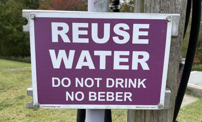
An additional complimentary approach to reduce nitrogen loadings, but likely able to do so more quickly, is through the tried and true strategy of “water reuse.” Here, highly treated wastewater from sewage treatment plants (STP’s) which contains low concentrations of nitrogen, is used in ways which “pulls out” the nitrogen. Water reuse is common practice in many places in the United States including Florida and California where the trademark purple-colored distribution piping is commonplace. Approximately 2.6 billion gallons of water is reused daily in the country, mostly for golf course irrigation but also for irrigating certain foods such as citrus trees.

The largest water reuse example on Long Island involves the Riverhead STP-Indian Island County Golf Course. With this project, from April to October, highly treated wastewater is directed to the adjacent Indian Island County Golf Course rather than being discharged into the Peconic River. According to engineering projections, the effort annually results in about 1.4 less tons of nitrogen entering the estuary, being taken up by the grass, and keeps about 63 million gallons of water in the ground since golf course wells no longer need to pump irrigation water from the aquifers.

With funding support the Seatuck Environmental Association has hired Cameron Engineering & Associates to develop an islandwide “Water Reuse Road Map” to guide future reuse projects. A potential local project, similar to the Riverhead example, tentatively identified in the roadmap involves redirecting wastewater from the SUNY Stony Brook STP which currently discharges into Port Jefferson Harbor and use it to irrigate the St. Georges Golf Course and Country Club, situated several hundreds away from the STP on the east side of Nicolls Road in East Setauket.

The third source of nitrogen contamination — fertilizers — has also received focus although progress here has been slower. A Suffolk County law, among other things, prohibits fertilizer applications from November 1st through April 1st when the ground is mostly frozen and little plant growth occurs. It also prohibits, with certain exemptions such as golf courses, fertilizer applications on county-owned properties. Several bills, both at the county and state level, have been introduced to limit the fraction of nitrogen in fertilizer formulations and to require “slow release” nitrogen so it can be taken up by plants and not leach into groundwater.

A basic concept that has emerged from a better understanding of how Long Island’s groundwater system works and the threats to it, is the value of the aforementioned “deep-flow recharge areas” serving as groundwater watersheds, these watersheds recharging voluminous amounts of water to the deepest portions of the underlying aquifers. And we’ve also learned “clean land means clean water.” 

Where the land surface is dominated by pine and oak trees, chipmunks, native grasses, blueberries, etc., the groundwater beneath is pure, as there no sources of potential contamination on the surface. It has become clear that Long Island’s forested watersheds play an important role in protecting Long Island’s groundwater system.

In recognition of the direct relationship between the extent to which a land surface is developed and the quality of drinking water below it, a state law was passed establishing on Long Island SGPA’s — “Special Groundwater Protection Areas” — lightly developed to undeveloped landscapes within the deep-flow recharge zones that recharge clean water downward, replenishing the three aquifers; the 100,000 acre Pine Barrens forest being the largest and most significant SGPA. 

There are seven other SGPA’s including the Oak Brush Plains SGPA just east of Commack Road and south of the Pilgrim State Hospital property; the South Setauket SGPA in northwestern Brookhaven Town, bisected by Belle Meade Road; one on the North Fork; two on the South Fork; and two in northern Nassau County. These areas collectively recharge tens of millions of gallons of high to pristine quality water to the groundwater system on a daily basis. The state law mandated the development of a comprehensive plan designed to safeguard the land surface and the water beneath it in all the SGPA’s. Landscape protection took a step further in the Pine Barrens, where state law has safeguarded nearly 100 square miles of land from development.

Protecting a community’s water supply has been a challenge throughout recorded history. Many past dynasties and civilizations (e.g. China, Bolivia, Cambodia, Egypt, Syria, southwest United States) have collapsed or been compromised by failing to ensure adequate supplies of clean water. In modern times maintaining the integrity of a water supply has become one of the fundamental responsibilities of government. It is clear that various levels of government, from Washington, DC, to Albany, to local governments, have advanced a host of laws, regulations, strategies, and programs all designed to safeguard our water supply. 

The jury is still out, though, as to whether this collective governmental response will be adequate enough. While Pogo has been correct so far — we, the 2.7 million Long Islanders in the two counties have been the enemy — perhaps with the implementation of additional proactive responses we might prove the little opossum wrong.

A resident of Setauket, John Turner is conservation chair of the Four Harbors Audubon Society, author of “Exploring the Other Island: A Seasonal Nature Guide to Long Island” and president of Alula Birding & Natural History Tours.

Pixabay photo

By John L. Turner

This is the first in a two-part series on Long Island’s water supply.

When thinking about Long Island’s groundwater supply — its drinking water aquifers — it is helpful to visualize a food you might eat while drinking water — say, a three-tiered, open-faced turkey sandwich — a slice of cheese on top, a juicy, thick tomato disk in the middle, a slice of turkey on the bottom, all resting on a piece of hard, crusty bread. 

Well, substitute the Upper Glacial Aquifer for the cheese, the thicker Magothy Aquifer for the tomato, the Lloyd Aquifer for the turkey, and a “basement of bedrock” for the bread and you’ve got Long Island’s tiered groundwater system. It is this collection of groundwater aquifers — these sections of the sandwich — that are the sole source of water for all the uses Long Islanders use water for. Hydrologists estimate there’s about 90 trillion gallons of water contained in Long Island’s groundwater supply.

Our sandwich model described above is not fully accurate in that there is another layer called the Raritan Clay formation separating the Magothy and Lloyd Aquifers. This clay layer, about 200 feet thick, retards water movement (for a number of reasons water moves painfully slow through clay) and is referred to as an aquitard. So, in our sandwich model let’s make the thin but impactive clay formation a layer of mustard or mayonnaise. With the exception of this clay-confining layer, Long Island is essentially a million-acre sandpile whose geology is generally distinguished by subtle changes in the composition, texture, and porosity of its geological materials — varying mixtures of silt, clay, sand, gravel and cobbles which affects rates of water transmissivity or movement.

The basement of bedrock (the bread in our sandwich) that underlies all of Long Island is metamorphic rock estimated to be about 400 million years old. It slants from the northwest to the southeast dipping at about 50 feet to the mile. So, while the thickness of the freshwater aquifers in northwest Queens is only a few hundred feet, it is approximately 2,000 feet thick in western Southampton.

On the North and South Forks and the south shore barrier islands, freshwater doesn’t extend all the way to bedrock as it does in Nassau County and much of western and central Suffolk County. It is shallowest on the barrier islands, the freshwater lens extending down only several dozen feet. 

On the North Fork it goes a little deeper before the water becomes salty and it is deepest on the wide South Fork where the freshwater lens extends downward about 550-600 feet. The depth of the aquifer is influenced by how many feet above sea level the water table is. There’s a hydrological formula, called the Ghyben-Herzberg principle, that states for every foot of water above sea level there’s 40 feet of freshwater beneath.

The water in the groundwater aquifers isn’t stored in large subterranean pools or caverns, as it is in some other places in the country with markedly different geology, Rather, the water is situated between the tiny, interstitial spaces existing between the countless sand particles that collectively make up Long Island. Given this, it is not surprising that groundwater flows (under the influence of gravity) slowly downward and sideways (depending where in the aquifer the water is located) moving on the order of just a few feet a day at most but typically in the ballpark of about one foot per day. 

It takes dozens to hundreds to thousands of years for water to move through the system, all depending where it first landed on the island’s surface. Water pumped from the seaward edge of the lowest aquifer — the Lloyd Aquifer — may have fallen as rain many years before the beginning of the ancient Greek Empire.

In the late 1970’s several governmental studies helped us to better understand some of the basics as to how the groundwater system works. One of the important takeaways from this research was that it is the middle half to two-thirds of the island that is most important for recharge — this segment is known as the “deep-flow recharge area” because a raindrop that lands here will move vertically downward recharging the vast groundwater supply. 

The middle of this area is knows as the “groundwater divide”; a water drop that lands to the south of the divide will move downward and then laterally in a southern direction discharging into one of the south shore bays or the salty groundwater underneath the Atlantic Ocean while a drop to the north will move eventually into Long Island Sound or the sandy sediments beneath it.

Hydrologists have determined that for every square mile of land (640 acres) an average of about two million gallons of rain water lands on the surface with about one million gallons recharging the groundwater supply on a daily basis. What happens to the other one million gallons? It evaporates, runs off into streams and other wetlands, or is taken up by trees and other plants that need it to sustain life processes such as transpiration (a large oak tree needs about 110 gallons of water daily to survive). 

In contrast, raindrops that land in locations nearer to the coasts such as in Setauket, northern Smithtown, southern Brookhaven, Babylon, or other places along the north and south shores don’t become part of the vast groundwater reservoir; instead, after percolating into the ground the water moves horizontally, discharging either into a stream that flows to salty water or into the salty groundwater that surrounds Long Island. These landscape segments are referred to as “shallow-flow recharge areas.”

The higher elevations along the Ronkonkoma Moraine (the central spine of Long Island created by glacial action about 40,000 years ago) are also the highest points in the water table although the water table elevation contours are a dampened expression of the land surface. So, in the West Hills region of Huntington where Jayne’s Hill is located, the highest point on Long Island topping out at a little more than 400 feet, the elevation of the water table is about 80 feet above sea level. 

Below the water table is the saturated zone and above it the unsaturated zone where air, instead of water, exists in the tiny spaces between the sand particles (in the Jayne’s Hill case the unsaturated zone runs about 320 feet). It is the water (more precisely its weight) in the higher regions of the saturated zones that pushes on the water beneath it, driving water in the lower portions to move at first sideways or laterally and then to upwell into the salty groundwater under the ocean. Due to the weight of the water the freshwater-saltwater interface is actually offshore on both coasts, meaning you could drill from a platform a mile off Jones Beach and tap into freshwater if you were to drill several hundred feet down.

A wetland forms where the land surface and water table intersect. It may be Lake Ronkonkoma, the Nissequogue or Peconic River, or any of the more than one hundred streams that drain the aquifer discharging into bays and harbors around Long Island. So when you’re gazing at the surface of Lake Ronkonkoma you’re looking at the water table — the top of the Long Island groundwater system. Since the water table elevations can change due to varying amounts of rain and snow and pumping by water suppliers these wetlands can be affected; in wet years they may enlarge and discharge more water while in droughts wetlands can largely dry up which happened on Long Island in the 1960’s.

It is clear, given the isolated nature of our water supply — our freshwater bubble surrounded by hostile salt water — that we are captains of our own fate. Our groundwater supply is the only source of water to meet all of our collective needs and wants. There are no magical underground freshwater connections to Connecticut, mainland New York, or New Jersey. We are not tied into, nor is it likely we will ever be able to tap into, New York City’s water supply, provided by the Delaware River and several upstate reservoirs. As the federal Environmental Protection Agency has declared — Long Island is a “sole source aquifer.” To paraphrase the late Senator Daniel Patrick Moyhihan: “Long Islanders all drink from the same well.” Indeed we do.

The next article will detail the quality and quantity problems facing our groundwater supply.

A resident of Setauket, John Turner is conservation chair of the Four Harbors Audubon Society, author of “Exploring the Other Island: A Seasonal Nature Guide to Long Island” and president of Alula Birding & Natural History Tours.

by -
0 130

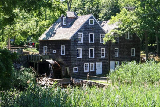
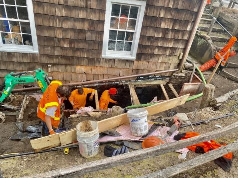
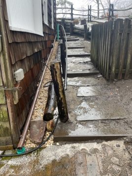
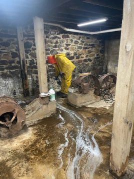
The Ward Melville Heritage Organization (WMHO)’s Stony Brook Grist Mill, a nearly 300-year-old building, has undergone a series of procedures to stop water from entering its basement. Groundwater around the foundation of the building has been leaking through the walls due to the hydraulic pressure from upstream for years.

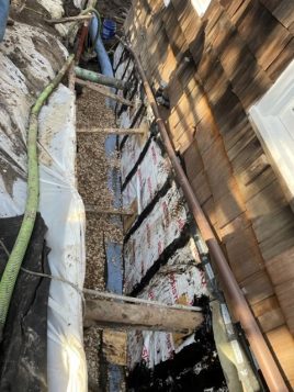
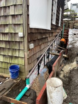
To halt any further damage and repair the structure, Excav Services Vice President Dylan Governale was retained. Excav Services has already begun their work waterproofing the wall below the footing with black mastic against the foundation along the fiberboards and then protection board and installing drainage at the bottom of the trough, as well as installing three inches of clay material and fabric and then backfilling it. 90% of the water has stopped leaking. To find the remaining 10%, the interior wall was pressure washed to see where the water was coming from and then they will inject those spots with a compound to fully stop leakage through the walls.

The Stony Brook Grist Mill (c. 1751) is Long Island’s most fully operational mill. A mill is a place that grinds grains such as wheat, barley, corn and oats. Grist Mill has played a role in the development of Stony Brook since its original construction in 1699. It was once even a health food store and grain was shipped to 46 states. 

New stories have been uncovered about the Stony Brook Grist Mill, including ones about its patriotic owners during the American Revolution, a scandalous will and its suffragette owner in the early 1900s who sought an experimental child birthing experience.

People of all ages are able to experience the history and inner mechanics of the mill in the WMHO’s Dusty Program.

The Stony Brook Grist Mill will be open for the 2022 season on Saturday, April 16 and will be open on weekends through October starting the weekend of April 23, from 1 p.m. to 4:30 p.m. for tours ($4 for adults, $2 for children), as well as its Country Store. For more information, call 631-751-2244 or visit www.wmho.org.

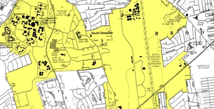
This state Department of Environmental Conservation map hilights special groundwater protection property in yellow, which includes a lot in the center on which a North Shore developer hopes to build.

A Setauket-based civic group is drawing a line in the sand as a North Shore developer looks to build three houses on an environmentally sensitive area.

Brookhaven is home to two of Long Island’s nine special groundwater protection areas, designated by the state Department of Environmental Conservation, and Charles Krohn of Windwood Homes, Inc. has applied for variances to divide his land within one of them — in East Setauket near Franklin Avenue and John Adams Street —  into three separate plots. But Shawn Nuzzo, president of the Civic Association of the Setaukets and Stony Brook, argued the town should adhere to existing zoning laws there to protect the area’s aquifer.

The DEC’s special groundwater protection area in question is a large, oddly shaped chunk of land on the North Shore that includes Stony Brook University, St. Georges Golf and Country Club, Ward Melville High School, wooded properties on the southern part of Setauket, pieces of Lake Grove and more.

“[This area] is critical to ensuring the future potability of our underground water supply,” Nuzzo said in a statement read aloud at the April 22 Brookhaven Town Board of Zoning Appeals meeting. “Granting variances to allow for these substandard lots would serve to undermine not only the state environmental conservation law, but also … Brookhaven’s own adopted comprehensive land use plan.”

The civic president said the town granted the area special protection in its 1996 land use plan — the most recently adopted plan to date — because of its environmental significance. In his testimony, Nuzzo asked the town to deny the requested variances solely to protect the environmental standards already in place, adding he was not opposed to development all together.

“If the applicant wishes to develop this property, we recommend they adhere to the town’s existing zoning ordinances,” he said.

Krohn, who lives in East Setauket, purchased the land from the town in September 2014 and said he was looking to build three homes between 3,000 and 3,500 square feet in the same community where Windwood Homes has already been developing for years.

“The houses might, in fact, be smaller than this footprint,” he said at last month’s Board of Zoning Appeals meeting. “These are not sold right now.”

Diane Moje of D&I Expediting Services in Farmingville represented Krohn at the hearing and said the goal was to make three equal lots for development.

East Setauket resident Thomas Cardno has lived near Franklin Avenue for nearly a decade and said he worries that overdevelopment would create a safety risk for young children, referring to the variance proposals as “jamming three homes on there” as a means to maximize profits at the expense of the families in the area.

The cul-de-sacs in the area are too crammed already, he said. “Just put two homes in there and call it a day, at this point.”

Moje, however, said the town has already granted similar variances for other homes in the surrounding area, making the current proposal nothing out of the ordinary.

“This is not out of character and not something this board hasn’t addressed previously, and granted,” she said.

Christopher Wrede of the Brookhaven Town Planning Department reviewed the proposal and said the variances posed no significant environmental impact. The Board of Zoning Appeals held the public hearing open, to get additional information in the coming months.