Tags Posts tagged with "beach erosion"

beach erosion

The Port Jefferson Country Club at the edge. Photo from Village of Port Jefferson

It’s been a long and harrowing timeline of events for local officials and residents who use East Beach and the surrounding country club.

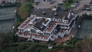
For years now, the village has been preparing for this moment, where the tennis courts and Port Jefferson Country Club have seemingly moved to the edge of the cliff overlooking the beach thanks to climate change and the ever-increasing erosion.

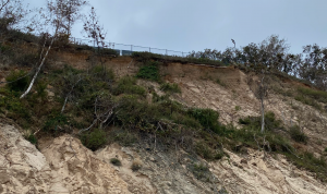
To the naked eye, one can see a gazebo in photos hanging by a thread. The tennis courts will be next. Eventually, if nothing is done, the club could potentially collapse into the harbor and have devastating impacts on the local environment. Over the course of several months, Mayor Margot Garant, village administrator Joe Palumbo and the village trustees have been anticipating this moment where something needs to be done now.

“We lost so much material,” Garant said. “The deck is approximately 30 feet from the bluff line … the gazebo isn’t there anymore. We’re getting very, very close to the bluff.”

Because the tennis courts are so close to the edge now, tennis at the country club had to be canceled for this season.

A view of the eroding bluff. Photo from Village of Port Jefferson

The backstory

In February, a representative from CGI Engineering, Varoujan Hagopian, presented to the board what could happen with three different options on the table: build a wall at the bottom of the bluff; renovate the building and surrounding areas upland; or do nothing at all.

Hagopian said that many clients he works with on the Eastern Seaboard are experiencing the same, or similar issues. “If you do nothing, this kind of erosion will continue,” he said. “I estimate the building will be totally damaged or gone in three to five years. I’m not trying to scare you, but these are realistic calculations.”

Hagopian added that although the building might be gone, that means it will impact the road and East Beach as a whole. The erosion won’t stop at the club.

Two weeks later at the March 3 work session, the board listened in to Garant’s presentation on the bluff, where she gave a detailed history of just how much East Beach has been through over the last decade.

The restoration project began in 2010, with engineering group GEI working on several projects that included the sea wall restoration, the west end wall extension, a ramp installation, a large jetty project and sand dredging, which was finally completed in 2021.

Garant said that the village and its surrounding beaches have seen devastating effects of different storms throughout the years, including Irene, Sandy and more recently, Isaiah back in September.

Aerial shot of Port Jefferson Country Club. Photo from Village of Port Jefferson

Finding funding

Meanwhile, Palumbo has been working with the DEC and with FEMA applications to try to get some federal funding — a feat that takes a lot of time and a lot of patience.

The East Beach Bluff Stabilization Phase I project’s DEC permit was originally filed in 2016, finally being awarded in June 2021, with the U.S. Army Corps of Engineers’ approval being obtained in September.

The DEC approved plans call for 454 linear feet of steel wall and rock revetment with tiebacks to stabilize the lower bluff and bolstering the “groin” to prevent further erosion into the roadway, according to a February presentation.

A significant expense of the entire project is the replanting of the entire flank of the hill which includes core logs, erosion control blankets, wood terracing, soil anchors and tens of thousands of native plants, including woody plants, beach and switch grasses.

The comprehensive project and detailed drawings were put out for competitive bidding. Twelve bids came in ranging from $4.8 million to $6.2 million. Funding the project will require a bond initiative, which will have an impact of increasing the typical household tax bill by approximately $147 per annum over the 15-year term if no other sources of funding are available or if no other budgetary changes are made.

The final awarded bid for the lower wall project ended up being $4.3 million. But when it comes to federal funding, the village is competing with other locations which have had their share of issues with Mother Nature.

“We were denied the application for the reimbursement of the bluff, they claimed, in short, that it was an existing condition,” Palumbo said. 

“We’re appealing that because we know it’s a preexisting condition and it’s going to be a condition that will continue to occur if our measures aren’t taken to the bluff.” 

The village has recently enlisted the assistance of Congressman Lee Zeldin (R-NY1), who is offering his full support to the appeal to FEMA and helping to seek other funding sources. 

Palumbo added that he has been in talks with decision makers with FEMA weekly, and has been scouring to find other types of funding that could help offset the cost.

“This is probably one of the most expensive projects any municipality on Long Island has ever had to deal with,” Garant said. “This is a severe erosion issue and it’s not going away. We might lose a lot more than we already have lost if we don’t act quickly.” 

For more information, including the plans to stabilize and restore the bluff, visit the website portjeff.com/eastbeachbluff. 

An eroding bluff at Long Beach has been stabilized by constructing a stone seawall at the bluff’s base. The bluff has been terraced to capture material that rolls down from the top and can be planted with vegetation that will help stabilize it. Photo from R. Lawrence Swanson

By R. Lawrence Swanson

Much has been proposed, written, and even implemented, to sustain, armor, adapt, make resilient and conserve the low-lying areas of Long Island’s South Shore since Hurricane Sandy five years ago. That coast is vulnerable to extensive inundation by accelerated sea level rise, the vagaries of storm surges and climate change. Indeed, there are core areas that now flood regularly on the semi-monthly spring tides.

The North Shore of the Island has been largely neglected in the sea level rise/storm surge discussions and planning even though it is equally vulnerable to these processes. The entire geomorphology of the North Shore is subject to change with or without anthropogenic intervention. The challenge is to be able to manage this change so that the environmental services — harbors of refuge, beaches, wetlands, fisheries, aesthetics — provided by the complex, precarious topography of the North Shore remain functionally stable for the region, communities and private interests.

Much of the North Shore is composed of unconsolidated morainal bluffs — many 50 feet or higher — accompanied by down-current cobble barrier beaches. These spits form the small pocket bays and harbors that are the locations of historic settlements. They provide refuge for people and marine ecosystems from the energy of waves and storms. The beautiful pocket bays of Mount Sinai, Port Jefferson, Stony Brook, Northport, Huntington, Cold Spring Harbor and Oyster Bay are now the cultural centers of the North Shore.

The protective spits that form these bays are fed by erosion of the adjacent coastal bluffs. In order for the pocket bays to be maintained, spits must have a sufficient sediment supply to overcome erosional forces and sea level rise, which is currently increasing at about 1.5 feet a century in Long Island Sound, but undoubtedly will accelerate here and globally. The general process is that the bluffs are undercut at their base or toe by waves and extreme tides. This undercutting will become more severe as sea level rises and we experience greater and longer lasting storm surges in the coming years. The bluffs then slump — about 2 feet per year — creating new beach material, some of which is transported by littoral (near-shore) currents to create and sustain the barrier spits. The small beaches at the toe of the bluffs reduce the wave run-up and thus bluff erosion.

“The North Shore of the Island has been largely neglected in the sea level rise/storm surge discussions and planning even though it is equally vulnerable to these processes.”

— R. Lawrence Swanson

Construction of seawalls for which there is increasing demand along the bluff faces hinders these natural processes. Beaches fronting the bluffs will disappear so that waves will be beating directly on the seawalls. Little material will be available for transport to maintain the barrier spits with rising sea level. Those spits will then be subject to overwashing — perhaps exposing the embayments behind continuously to the open waters of the Sound.

What can be done in the way of resiliency to preserve the character of the North Shore and yet also protect individual properties on the Sound — both those on the cliffs and those on the barrier spits? Is hardening the bluffs and beaches at great expense the answer? Do we let nature take its course? Do residents on the barrier beaches have rights to the sediment of eroding cliffs in much the same way that downstream California claims rights to Colorado River water? If hardening of bluffs is allowed, will there be enough sediment at the toe to maintain a beach to reduce wave run-up?

New York State needs to examine this issue and develop guidance that works for all. Current policies are confusing and perhaps conflicting. This is a regional issue that cannot be solved property by property or even on a town-by-town basis.

With the state of development on the North Shore, some form of intervention or adaptation is probably required; nature cannot be left totally unchecked, given the grim climate projections for this coming century. Extensive hardening of the shoreline is equally unpalatable. There are negative downstream effects from almost all anthropogenic solutions. We need to understand and minimize them. Once started, hardening will eventually result in entombing us, totally eliminating the natural beauty and functionality of the North Shore that we enjoy. Perhaps there are softer forms of resilience that will allow preservation of natural processes yet significantly reduce the anticipated severe erosion from wind, rain, accelerated sea level rise and climate change. We need to find those techniques and implement them consistently.

In the meantime, there are zoning measures that can be practiced that will reduce erosion of these steep coastal faces — establish respectable setbacks, reduce or eliminate clearing, minimize variances resulting in overbuilding and consider downstream impacts of stabilization measures.

Long Island’s low-lying South Shore is at risk to the negative impacts of storm surge, sea level rise and climate change and much attention is being given to it. The North Shore, while seemingly elevated from these impacts, is not. Because its steep coast consists of unconsolidated sediments, it will experience extensive erosion. We need to understand, plan for and implement regional adaptive measures to reduce potential adverse effects to assure resilience of this vulnerable coastal environment.

R. Lawrence Swanson is the interim dean and associate dean of the Stony Brook University School of Marine and Atmospheric Sciences.

A steam shovel fills a waiting dump truck to distribute sand along West Meadow Beach. By Donna Newman

Winter strolls along West Meadow Beach have been put on hold to avoid future environmental and boating problems.

Since Dec. 4, the Town of Brookhaven beach and Trustees Road in Stony Brook have been closed to the public. The town’s parks  department made the decision to accommodate an ongoing Suffolk County dredging project.

“It was the determination of the law and parks departments to close the beach due to safety and liability issues,” town Councilwoman Valerie Cartright (D-Port Jefferson Station) said. “Resident safety is paramount to the town.”

While the dredging project is in effect, multiple trucks and dredging equipment will be accessing the beach, which could potentially cause dangerous situations for visitors if the beach remained open.

Dredging is nothing new for Long Island waterways, according to Larry Swanson, interim dean and associate dean of the School of Marine and Atmospheric Sciences and director of the Waste Reduction and Management Institute at Stony Brook University. The sediment dredged from the depths of waterways is added to beaches to nourish the shorelines, which in turn helps to slow down erosion and protects structures from rising sea levels and storm surges. He said dredging projects are ideally done in the winter to protect marine organisms, which aren’t as active during the season as they are in warmer months. He said the currents are typically strong where the county is dredging, which most likely will produce clean sand and gravel.

Swanson said Long Beach in Smithtown, which is located slightly west of the Stony Brook beach and regularly needs dredging material, is progressing to the east/northeast about 1 yard per year.

“What that does as it progresses, it tends to cause the currents to eat into West Meadow Beach,” he said. “So when that happens, sometimes there’s a cut that forms in West Meadow Beach.”

The dean said it is ideal to fill up the cut so it doesn’t keep eroding, as there’s a possibility in 20 years that it could break into West Meadow creek.

“The preservation of beaches as we know them is somewhat depending upon this source of dredge material,” Swanson said.

The dean said dredging is done for other reasons, too.

“The channel coming into Stony Brook Harbor fills up to the point where the low water depth is no more than 1 or 2 feet, and most boats that enter Stony Brook Harbor have a draft in excess of 1 or 2 feet and so they hit bottom,” Swanson said. “People don’t want to damage their boats.”

West Meadow Beach is expected to reopen on or about Jan. 1, according to a statement from Brookhaven Town.