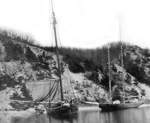
The wreck of the sloop Emperor, pictured on the east shore of Port Jefferson Harbor, is no longer visible. The packet sailed between New York City and Port Jefferson carrying freight and passengers. Photo by Arthur S. Greene, photo from the Kenneth C. Brady Digital Archive.
Sailing from Port Jefferson, the sloop Emperor reigned in local waters from 1829-1898.
Contracted by Captain Caleb Kinner of Port Jefferson, the 60-foot Emperor was built in Derby, Connecticut, by Zephaniah and Israel Hallock.
Launched in 1829, the Emperor ran as a packet, carrying freight and passengers on regular trips between Port Jefferson and New York City.
At the Emperor’s inception, Port Jefferson was without rail service, the packet providing a vital link between the village and the metropolis.
The Emperor typically left Port Jefferson on Tuesdays and returned on Fridays, distinguishing itself during New York City’s cholera outbreak in summer 1832 by transporting panic-stricken people fleeing the epidemic and escaping to the country.
While steamboats eventually replaced the Emperor on the profitable Port Jefferson-New York route, the sloop remained a moneymaker in the coastal trade, sailing from Long Island to ports as varied as New Haven, Connecticut, and Haverstraw, New York.
The Emperor, left, is shown anchored off the east shore of Port Jefferson harbor. The packet was the subject of a poem by William M. Davis. Photo by Arthur S. Greene, photo from the Kenneth C. Brady Digital Archive.
Although tossed on the beach during a September 1892 storm, and reportedly “wrecked beyond repair,” the battered Emperor was on the Sound the next month bound for New York with a load of cordwood.
Described as a “decrepit, played-out sloop” in “Old Drown’ Meadow Packet,” an 1895 poem by William M. Davis, Port Jefferson’s foremost painter, the Emperor was still considered a good buy in spring 1895 when she was purchased by Captain Caleb Norton of Mount Sinai, New York.
The tired, sea-soaked Emperor somehow held together until 1898, the last year she was listed in Merchant Vessels of the United States, ending her days as purportedly the oldest sloop then afloat in Brookhaven Town.
The wreck of the Emperor, long a subject of amateur and professional photographers, sat for years on the east shore of Port Jefferson Harbor, but is no longer visible.
Kenneth Brady has served as the Port Jefferson Village Historian and president of the Port Jefferson Conservancy, as well as on the boards of the Suffolk County Historical Society, Greater Port Jefferson Arts Council and Port Jefferson Historical Society. He is a longtime resident of Port Jefferson.
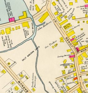
Port Jefferson’s salt meadow land is depicted west of Jones Street, today’s Main Street, on this portion of E. Belcher Hyde’s 1909 Atlas of Suffolk County, volume two. Photo from Kenneth C. Brady Digital Archive
Typhoid fever broke out in Port Jefferson in 1919, 1921 and 1924, sickening scores of villagers, claiming the lives of others and revealing shortcomings in the public health system.
Although uncommon in the United States today, typhoid fever is contracted by eating food or drinking beverages that have been handled by someone who is shedding Salmonella Typhi or if sewage contaminated with the bacteria gets into the water used for washing food or drinking.
The symptoms of typhoid include sustained fever, weakness, stomach pain, headache, diarrhea or constipation, cough and loss of appetite.
The communicable disease struck Port Jefferson during September and October 1919, resulting in 29 cases and one death. The State Health Department concluded that the outbreak was probably due to the “infection of the milk supply by a typhoid carrier.” Officials who investigated the epidemic found other unsanitary conditions in Port Jefferson.
Sewage was disposed in the village’s downtown by surface drains which emptied on the salt meadows located west of Jones Street, now Main Street. The marshes flooded during high tide, carried human waste over a wide area and polluted soil and water.
Port Jefferson’s salt meadow land is depicted west of Jones Street, today’s Main Street, on this portion of E. Belcher Hyde’s 1909 Atlas of Suffolk County, volume two. Photo from Kenneth C. Brady Digital Archive
The salt meadow land, referred to as the “swamp section” in local parlance, was used as a public dump, known for its horrible stench and avoided by villagers during low tide when the unsightly filth hidden by high water was exposed.
As early as 1894, members of the Ladies Village Improvement Society had urged Brookhaven Town to build modern sewers in Port Jefferson, but a new system was still not in place during the 1919 typhoid outbreak.
The dread disease returned to the village in fall 1921, left 14 dangerously ill and took the life of prominent Port Jefferson businessman Gilbert E. Loper. Once again, a dairy employee was suspected of being a typhoid carrier.
Charles L. Bergen, former chief of the Port Jefferson Fire Department, fell victim to typhoid in August 1924 when the disease struck the village and sickened 31 others. Health officials surmised that the typhoid outbreak was likely “milk-borne,” adding that the offending milk was unpasteurized and that local dairies were not regularly inspected.
The epidemic also showed that Port Jefferson was unprepared to handle the surge of typhoid victims. St. Charles Hospital then specialized in the care of disabled children and Mather Hospital was yet to open.
The Catholic sisters from the Daughters of Wisdom had graciously proposed to establish an annex on the grounds of St. Charles Hospital for typhoid sufferers alone. Out of an abundance of caution, their kind offer was not accepted because there was a dairy nearby the planned site.
When a critically ill patient from Port Jefferson was transported to a private hospital in Patchogue for medical treatment, some of the latter’s merchants decried the move, contending it might frighten away summer vacationers during the height of the tourist season.
Jacob Dreyer, editor of the Port Jefferson Times, attacked the Patchogue Argus, alleging that its slanted coverage of the typhoid outbreak was no more than an attempt to boost Patchogue at the expense of its stricken sister village.
The Port Jefferson Business Men’s Association was also concerned about the impact of the outbreak on the local economy, arguing that the metropolitan newspapers had exaggerated conditions in the village and that the negative publicity had dampened sales in Port Jefferson.
The city papers countered that both the Port Jefferson Echo and Port Jefferson Times had suppressed news of the epidemic and sugarcoated the harsh reality of the outbreak.
As no new typhoid cases were reported in Port Jefferson and life returned to normal in the village, there were calls for a county hospital, model health laws and full-time health officers.
The epidemic also stoked long-simmering tensions between Patchogue and Port Jefferson and revived calls for Port Jefferson’s incorporation and the village’s right to govern independent of Brookhaven Town.
More important, the outbreak led to improvements in Port Jefferson’s sewerage system, frequent inspections of local dairies, the filling in of the village’s lowlands and other prevention measures, effectively ending the scourge of typhoid fever in Port Jefferson.
Kenneth Brady has served as the Port Jefferson Village Historian and president of the Port Jefferson Conservancy, as well as on the boards of the Suffolk County Historical Society, Greater Port Jefferson Arts Council and Port Jefferson Historical Society. He is a longtime resident of Port Jefferson.
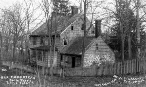
The Old Homestead stood near the corner of what is now Port Jefferson’s Winston Drive and Crystal Brook Hollow Road.
Photo by Arthur S. Greene; Photo from Kenneth C. Brady Digital Archive
What is now Belle Terre, coupled with an area in today’s Port Jefferson, once comprised the 1200-acre Oakwood estate.
Surrounded on three sides by water, the property featured a country house, tilled land, woodlots, a hothouse, fruit and nut trees, sheepfolds, springs, an icehouse, a dairy, pigpens, barns and outbuildings.
The estate even included a private cemetery, the Sugar Loaf Burying Grounds, where some of Oakwood’s workers and their family members had been interred.
Mary B. Strong, known as “Lady Strong,” presided over the estate. In 1880, she was considered the wealthiest woman in Brookhaven Town, where she numbered among its largest taxpayers.
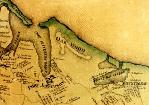
Oakwood is depicted on this portion of J. Chace’s 1858 Map of Suffolk County, L.I., New York. Photo from Kenneth C. Brady Digital Archive
William A. Hopkins and Charles A. Davis, Miss Strong’s trusted overseers, supervised day-to-day operations at Oakwood, everything from milking cows to cutting cordwood.
Lady Strong and her servants lived at the estate’s Old Homestead which stood near the corner of what is now Port Jefferson’s Winston Drive and Crystal Brook Hollow Road.
A short walk from tranquil Mount Sinai Harbor, the country house was the scene of elegant parties hosted by Miss Strong and surrounded by grounds lovingly tended by a gardener.
Responsible outdoorsmen were welcomed at Oakwood, where they hiked its shaded paths, hunted, trapped and gathered berries. Vacationers from Bridgeport, Connecticut sailed across Long Island Sound and pitched tents on the property at Camp Woodbine, while day-trippers picnicked on the estate at Saints Orchard.
After Lady Strong’s death on April 9, 1885, Oakwood reverted to her nephews, but through neglect, the once well-maintained estate went to ruin.
In spring 1901, surveyors were seen marking Oakwood’s boundaries and that winter advertisements had appeared in the New York Times announcing the property’s sale.
The Old Homestead stood near the corner of what is now Port Jefferson’s Winston Drive and Crystal Brook Hollow Road. Photo by Arthur S. Greene; Photo from Kenneth C. Brady Digital Archive
Clinton L. Rossiter, vice president of the Long Island Loan and Trust Company, purchased Oakwood from Mary B. Strong’s heirs in 1902. Rossiter represented a group of investors who planned to build a “private residence park,” known today as Belle Terre, on the land.
Over the ensuing years, the site was developed, and the Old Homestead was destroyed in a suspicious fire, leaving only street names such as Oakwood Road as reminders of Lady Strong and her vast estate.
Kenneth Brady has served as the Port Jefferson Village Historian and president of the Port Jefferson Conservancy, as well as on the boards of the Suffolk County Historical Society, Greater Port Jefferson Arts Council and Port Jefferson Historical Society. He is a longtime resident of Port Jefferson.
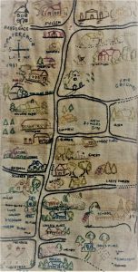
Amongst the Middle Country Public Library’s many historical artifacts are a few that explain just how far the area has come from its pastoral roots. The picture and story below comes courtesy of a collaborative effort among the librarian staff.
This beautifully embroidered map was gifted to Middle Country Public Library, and is part of the Heritage Collection, the library’s local history archives.
It shows a detailed and unique view of Centereach as it stood in 1937. Oriented in a west to east view from top to bottom, we can see the landmarks and homesteads that residents would visit and pass by daily.
Near the top right of the image, we can see the New Village First Congregational Church prominently featured in white, just south of the Fairgrounds. It was such a major landmark that it needed no caption. The steeple, front door and footpath are skillfully embroidered in. Homes of many residents (Overton, Emery, Olsen, Ulrich, Duffield, Campbell, Moen, Scudder and Alvin Smith, Bertram, to name a few) are painstakingly labeled along with many prominent businesses.
William Tobin’s “Ontheway” Rest, located on the northwest corner of Middle Country Road and Stony Brook Road served as a gasoline station and featured a lunch stand that Mrs. Tobin ran on the adjoining property.
Other establishments depicted include the barbershop, the grocery store, Homeside Nursery, the lumber yard and Carl’s Tavern, along with the Wilkinson, Williams, Moller and Murray farms.
If you look closely, a hen and her chicks are carefully stitched in, foraging about the Wilkinson’s farmyard. The fire house, fair grounds, and schools (both the existing and proposed new school sites), the Parsonage and Parish Hall are all here.
Streets are not labeled, but we know that Middle Country Road runs from top to bottom down the center of the panel and we can see where paving is incomplete on the right margin (the north side of the map). The New Village Congregational Church which stands today on Middle Country Road just west of Elliot Avenue and residences such as the Henry house help us determine the location of other streets.
We know that the Henry homestead was located at the corner of Middle Country Road and North Washington Avenue. We can also see William Wortley’s gas station which was situated on the south side of Middle Country Road opposite Wood Road, where the barbershop stands embroidered with the traditional red and white pole.
For an entertaining treasure hunt, take a look to discover what other family names and landmarks you can find. More names and places can be found on this map than we could list here. Have fun!
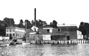
Lester H. Davis’ Ice Plant was located along the waterfront on the north side of East Broadway. Photo by Arthur S. Greene, photo from the Kenneth C. Brady Digital Archive
Parker’s Pond was an artificial body of water located in Port Jefferson, west of Main Street, directly across from today’s First United Methodist Church.
Long filled in, the man-made pond was created by stonecutter Andrew J. Parker, who in 1861 — along with his wife and children — settled in Port Jefferson where the opening of Cedar Hill Cemetery two years earlier had brought job opportunities for tombstone sculptors.
In 1865, Parker bought a house and meadow land at the foot of Port Jefferson’s Spring Street and established a marble works on the site.
Not just a stonecutter, Parker was also a blacksmith skilled in building ploughs for harvesting ice.
Parker’s Pond, also known as Crystal Lake, was located west of Main Street, directly across from today’s First United Methodist Church. Photo by Arthur S. Greene, photo from the Kenneth C. Brady Digital Archive
Natural ice was a valuable commodity during the 19th century. Collected in winter from frozen ponds, lakes and rivers, the crystal treasure was stored in icehouses until the warmer months. The ice was then sold and used in domestic and commercial settings to preserve food, cool drinks and prepare ice cream.
In 1869, Parker presaged his entry into the lucrative ice trade by purchasing Port Jefferson meadow land neighboring his business and cobbling together the separate parcels into one large tract.
A stream originated in the hills above Parker’s newly acquired property, ran north through his land, flowed into Port Jefferson’s salt meadows, joined the village’s Old Mill Creek, and discharged into Port Jefferson Harbor.
Parker created a pond by damming the stream as it crossed his property, first clearing the land and then in partnership with Josiah Randall building an icehouse to serve the site.
In winter 1873, ice was first harvested from the pond by Parker’s Crystal Lake Ice Company, the names Parker’s Pond and Crystal Lake soon becoming synonymous.
Over the years, the pond and its icehouse were leased to various parties who cut the ice and stored the crop. In 1881, Crystal Lake reportedly yielded 600 tons of quality ice.
In 1891, directing his energy to the temperance movement, Parker sold his two-acre pond to investor John Davis.
Davis leased the pond in 1893 to the Nassau Trout Association. The freshwater anglers stocked Crystal Lake with fry but abandoned the venture in 1894.
In 1901, butcher Lester Davis opened an ice plant on the north side of Port Jefferson’s East Broadway, effectively ending natural ice harvesting at Crystal Lake. At Davis’ factory, artificial ice was manufactured year-round, unaffected by the vagaries of weather and safer than the products of suspect waters.
While Port Jefferson moved from old to modern technology, idyllic Crystal Lake remained a popular attraction among skaters. On some winter days, upwards of 100 people glided along on the frozen pond.
A scenic landmark in Port Jefferson, but no longer important to the ice trade, the pond as well as Parker’s former home were sold in 1910 to Fred Griswold, who also purchased Athena Hall (Theatre Three) in a separate transaction.
In 1911, Griswold’s North Shore Electric Light and Power Company reclaimed ground from Parker’s Pond and built a powerhouse on what is now Maple Place.
The landscape surrounding Crystal Lake continued to change as other structures rose near its waters. In 1927, the Port Jefferson Fire Department laid a cornerstone for its new station north of the pond on Maple Place.
In 1930, Griswold began showing “talkies” at the Port Jefferson Theatre, formerly Athena Hall, which he remodeled to seat 600 people. Griswold also provided free parking at the cinema, where patronage had increased following the introduction of movies with sound.
Lester H. Davis’ Ice Plant was located along the waterfront on the north side of East Broadway. Photo by Arthur S. Greene, photo from the Kenneth C. Brady Digital Archive
The parking lot was entered from Maple Place, could handle 200 cars, and made by dewatering Parker’s Pond and covering its exposed bed with cinders. As the dumping of fill continued, evidence of the former pond gradually disappeared.
Located in a declivity, Griswold’s parking field was subject to storm water runoff, but the construction of a box culvert in 1934 channeled the area’s surface waters and eased the situation.
In a village bedeviled by inadequate public parking, the theatre’s lot was eyed as a prime location for a municipal parking field.
In 1961, a local committee proposed the creation of a Port Jefferson Parking District, which would have entailed the building of a parking lot at what was once historic Parker’s Pond. Facing spirited opposition from villagers, the scheme was abandoned.
In September 1980, New York State’s Department of Transportation presented a proposal to build a parking field at the former Crystal Lake site.
Spokesmen for the Port Jefferson Fire Department argued that blacktopping and elevating the property would cause flooding at the firehouse on Maple Place.
Although the State later scrapped its plan, the Port Jefferson Fire Department bought the parcel, thus insuring the Department’s stewardship of the lot. Landscaped and seeded, the acreage is now used by the village’s volunteer firemen for training and recreation.
While there is no marker indicating that the site was formerly an ice pond, fish farm, skating rink, scenic landmark, and parking field, the soggy feel underfoot hints of earlier times.
Kenneth Brady has served as the Port Jefferson Village Historian and president of the Port Jefferson Conservancy, as well as on the boards of the Suffolk County Historical Society, Greater Port Jefferson Arts Council and Port Jefferson Historical Society. He is a longtime resident of Port Jefferson.
Amongst the Middle Country Public Library’s many historical artifacts are a few that explain just how far the area has come from its pastoral roots. The picture and story below comes courtesy of a collaborative effort among the librarian staff.
Photo from MC Library
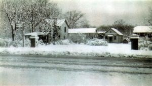
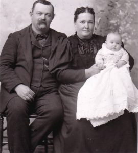
The junction of Boyle and Middle Country Roads in Selden was the setting for this early 1940s winter view of the homestead of Wendell Shipman Still (1896-1954) and his wife, Pauline Dare Still (1895-1950). They were married on March 29, 1920 and raised two daughters, Maybelle and Lucille in this home.
Wendell served in the U.S. Navy during World War I, and after receiving an honorable discharge in 1919, he returned to Long Island and purchased a truck farm in Selden. Still grew vegetables and raised poultry as a source of income.
By the 1940s, his poultry plant had the capacity to raise 250,000 chickens per year. He was a successful businessman, establishing Wendell Still Enterprises. Later, Still became a wholesale gasoline distributor and retailer of fuel oil and kerosene, as well as marketing various products, including different types of feed and commercial fertilizer.
Wendell was a very civic-minded citizen and a member of the American legion, the Selden Volunteer Fire Department, and the Port Jefferson Yacht Club. He also served as chairman of the Board of Trustees for the Selden Public School District.
Photo from MC Library
Pauline (Dare) Still was a lifelong resident of Selden. She attended public school in there and continued her education at the Patchogue High School. Pauline graduated from Cortland State Teachers College in 1916 and taught in both the Selden and Centereach schools for a period of 12 years. In this charming 1896 photograph, baby Pauline sits with her parents, Samuel and Henrietta (Wicks) Dare.
Pauline was very active in church, civic and local affairs, serving in the Ladies Auxiliary of the Selden American Legion, the Ladies’ Aid Society of the Coram Trinity, National Society of Daughters of the Union 1861-1865, Order of the Eastern Star and the Coram and Selden Community Clubs.
She also was one of the founders of the Farmingville Reunion Association and was instrumental in obtaining the Bald Hill School House when it was to be removed in 1929. The Greek Revival Style School House had served the community continuously from 1850 until 1929. Today, the Farmingville Historical society runs educational, recreational and virtual events in the School House and on the property.
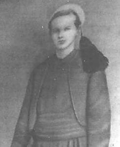
Samuel Dare, Age 16. This image was donated to the library’s collection by Samuel Dare’s great grandson and area resident, Larry Grignon.
Pauline’s father, Samuel Dare (1847-1913) was a Civil War veteran who enlisted in the Union army in 1863 at the age of 16. Samuel was part of the 165th Regiment, 2d Duryea Zouaves, (an elite fighting force) which was a division of the NY Volunteer Infantry. In this portrait, Samuel is dressed a Zouave uniform which included woolen trousers, shirt, waistband, jacket, and traditional tasseled hat.
Samuel was a lifelong member of Selden, active in community affairs, and member of a fraternal organization called the Grand Army of the Republic (GAR). This group was comprised of members of the Union Army, Navy and Marines who fought in the U. S. Civil War. He was a prominent member of the Selden community for many years, serving as a member of the Brookhaven Board of Trustees, serving as its president from 1894-1897.
Above: Sitting in a decorated touring car, Abram Bentley, Port Jefferson’s last surviving Civil War veteran, leads the village’s 1930 Independence Day Parade accompanied by his wife Marion. Photo from Kenneth C. Brady Digital Archive
On Memorial Day, we honor America’s fallen sailors and soldiers and decorate the graves of the men and women who served in the nation’s armed forces.
Among the comrades-in-arms buried at Port Jefferson’s Cedar Hill Cemetery, Abram Bentley was the village’s last surviving Civil War veteran.
Known locally as “Uncle Abe,” Bentley was born in Manhattan on Sept. 4, 1844 and apprenticed at a carriage factory while in his teens.
At the age of 20, Bentley enlisted in Company I, 39th Regiment, New Jersey Infantry, which fought the Confederates in Virginia. He was soon promoted to corporal and then sergeant.
After his discharge and return to civilian life, Bentley married Marion Wilson of Newark, New Jersey, on Dec. 9, 1866. Days later, the newlyweds traveled by the steamer Sunbeam from New York City to Port Jefferson, where a job awaited the groom.
Skilled as a wheelwright and an upholsterer, Bentley worked at Effingham Tuthill’s carriage shop on Main Street. After Tuthill left Port Jefferson in 1874, Bentley continued operating the establishment with Aaron Coles and John Baldwin. By 1886, as his partners withdrew from the business, Bentley became the sole proprietor of the company.
Besides running a manufactory, Bentley was active in Port Jefferson’s Baptist Church on East Main Street, today’s Harborview Christian Church. He was the superintendent of the Sunday School, a member of the choir, secretary/treasurer of the bible class, and a deacon.
He was also a Republican party stalwart, served on the election board and completed four terms as Brookhaven Town Auditor.
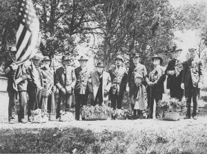
Never forgetting his time in the military, Bentley was a founder and later commander of Lewis O. Conklin Post 627, Grand Army of the Republic, a Union veteran organization with a “camp” in the village.
Under Bentley’s leadership, the Post organized Port Jefferson’s annual Decoration Day ceremonies which typically began with religious services at the Baptist Church. The GAR members, followed by a contingent of townspeople, then marched to Cedar Hill Cemetery.
After listening to a stirring patriotic address and martial music played by the Port Jefferson Brass Band, the veterans adorned the graves of their lost brothers with flowers, wreaths, crosses, and flags. Among those interred at the cemetery, there are over 40 soldiers and sailors who served with the North during the Civil War.
Below: Civil War veterans, Lewis O. Conklin Post 627, Grand Army of the Republic, are shown during Decoration (Memorial) Day ceremonies at Port Jefferson’s Cedar Hill Cemetery. Abram Bentley is fourth from the right. Photo by Arthur S. Greene. Photo from Kenneth C. Brady Digital Archive
Bentley also represented Port Jefferson at the GAR’s regional encampments, was a familiar figure at the head of the village’s Fourth of July parades and was drill master of the local Boys’ Brigade, a semi-military organization founded “to develop Christian manhood” among Port Jefferson’s youth.
“Uncle Abe” died at his home on Thompson Street on June 25, 1934. He was predeceased by his wife who had passed the previous March. They had been married for over 67 years.
On the day of Bentley’s funeral, the destroyer USS Lea (DD-118) was anchored in Port Jefferson Harbor to take part in the village’s 1934 Independence Day celebrations. The warship was named after an officer killed during the Civil War.
An honor guard from the Lea escorted the caisson carrying Bentley from the Baptist Church to his final resting place in Cedar Hill Cemetery, a fitting end for one of Port Jefferson’s beloved citizens.
Kenneth Brady has served as the Port Jefferson Village Historian and president of the Port Jefferson Conservancy, as well as on the boards of the Suffolk County Historical Society, Greater Port Jefferson Arts Council and Port Jefferson Historical Society. He is a longtime resident of Port Jefferson.
Two Porter-Knight racers are parked on Port Jefferson’s Main Street in front of the Ardencraig Inn. The establishment courted car aficionados. Photo by Arthur S. Greene. Kenneth C. Brady Digital Archive
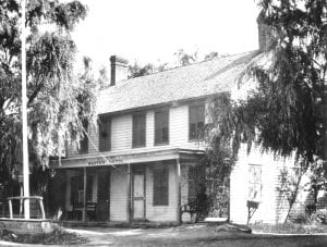
Smith’s Hotel was established in 1870 and located in Port Jefferson on the east side of Main Street, a short distance from the waterfront.
William R. Thompson began leasing the venerable hotel in 1908 from its longtime proprietor Lizzie Smith before actually buying the establishment in 1910.
Besides renaming the hotel the Ardencraig Inn, Thompson made other changes at the premises, adding guest rooms, enlarging the dining room, installing Blau-Gas lighting and introducing sanitary plumbing.
More important, Thompson recognized how automobiles were revolutionizing travel, giving people the freedom to explore the open road, and creating a new class of tourists no longer dependent on ships and trains.
To tap into this burgeoning market and popularize the Ardencraig, Thompson geared his publicity toward motorists.
The inn was featured in travel guides favored by car aficionados such as The American Motorist and The Automobile Blue Book.
With the ferry Park City running between Bridgeport and Port Jefferson, the Ardencraig was described in the Connecticut press as being ideally located to host “automobile parties” from New England.
A car enthusiast himself, Thompson was a member of the Automobile Club of Port Jefferson, which sponsored both the 1910 and 1911 Hill Climbs on the village’s East Broadway.
As a service for the motorists who were registered at the Ardencraig, Thompson had a garage constructed behind the inn. Besides providing accommodations for chauffeurs, the garage was manned day and night.
Lizzie Smith’s Hotel, later the Ardencraig Inn, was located on the east side of Port Jefferson’s Main Street, a short distance from the waterfront. Photo by George Brainerd. Kenneth C. Brady Digital Archive
While welcoming motorists to his hotel, Thompson did not neglect tourists who had arrived in Port Jefferson by rail or yacht. Events such as Old Home Week in 1911 brought thousands to the village, numbers of whom stayed at the Ardencraig.
Advertised in Port Jefferson’s newspapers as a “popular place for particular people,” the inn was also known among villagers for family gatherings, wedding receptions, card parties and balls.
After years of success, the Ardencraig’s run of good luck ended on March 2, 1920, when the inn was destroyed by a fire that purportedly originated with a defective flue. The hotel’s staff and guests, as well as Thompson and his wife, all escaped the burning building.
Following the blaze, Thompson presented plans to replace the Ardencraig with a 75-room hotel and an adjoining 1,300-seat theater, but without a sufficient number of investors, the project died.
Undaunted, Thompson built a new business on the site of his former hotel. Opening in 1920, the Ardencraig Bowling Alleys and Billiard Parlor was located on the north side of Arden Place. Known as the “Annex,” the structure featured three Brunswick alleys and four billiard tables on the first floor and a rooming house on the second.
The Ardencraig Alleys flouted the prohibition laws, leading to Thompson’s arrest in both 1922 and 1923 for illegally selling alcoholic beverages. After more violations of the Volstead Act, a judge granted a padlock injunction closing the business for one year.
The Ardencraig Alleys reopened in 1924, but without Thompson as the proprietor. He had leased the establishment to managers who had pledged to respect the dry laws.
Thompson left Port Jefferson in 1926 and became the treasurer of the Long Island Association. His move triggered more talks about building a hotel on the Ardencraig site, but again nothing materialized.
Meanwhile, the renamed Ardencraig Bowling and Billiard Academy operated under a succession of managers but closed because of lagging business. There was a call to purchase the property and use the building as a community center, but the proposal fell on deaf ears.
Although there was little interest in developing a hotel or community center on the Ardencraig site, the land was valued for other purposes.
The Port Jefferson Fire Department often used the empty Ardencraig property to hold its annual summer carnivals.
Because of its prized location in downtown Port Jefferson, the vacant Ardencraig space was also seen as an ideal location for a public parking lot.
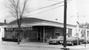
Wells Oldsmobile is pictured on the northeast corner of Port Jefferson’s Main Street and Arden Place, the site once occupied by the Ardencraig Inn. Kenneth C. Brady Digital Archive
In 1937, the Port Jefferson Merchants Association leased the Ardencraig site from its owner, Mary Thompson, the widow of William R. Thompson.
A portion of the Ardencraig property was quickly transformed into a parking lot, which opened in 1937 to applause from shoppers and shopkeepers alike.
Following Mary Thompson’s death in 1942, the Ardencraig property was sold at auction with the winning bid going to Port Jefferson’s First National Bank.
Under the Bank’s direction, the dilapidated “Annex” was demolished. The east end of the Ardencraig property was then graded and opened for free parking in 1943.
In 1948, Robert F. Wells purchased the Ardencraig property, where he built an Oldsmobile showroom and service center. Opening in 1949, the dealership itself was located on the corner of Main Street and Arden Place. A parking area for customers and a used car lot was to its rear.
With the closing of the Oldsmobile agency, the space was home to a Gristede’s supermarket and later The GAP. As of this writing, the building is unoccupied. The balance of the former Ardencraig property is now the site of a Port Jefferson Village parking lot.
Kenneth Brady has served as the Port Jefferson Village Historian and president of the Port Jefferson Conservancy, as well as on the boards of the Suffolk County Historical Society, Greater Port Jefferson Arts Council and Port Jefferson Historical Society. He is a longtime resident of Port Jefferson.
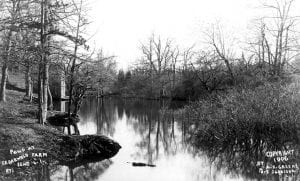
Cedarwold Farm was a dairy with about 100 acres of pasture.
Photo by Arthur S. Greene, from the Kenneth C. Brady Digital Archive
Cedarwold Farm was a dairy that operated in Port Jefferson Station from 1892-1908.
The farm was located about one third of a mile west of today’s Port Jefferson Railroad Station, south of Sheep Pasture Road, in what was then called Echo.
The dairy included about 100 acres of pasture and 25 acres of woodland, fruit trees, a natural pond, an icehouse, a farmhouse, barns and outbuildings.
The property was comprised of two tracts: the Emmet B. Darling plot, purchased by Ebenezer Reeve in September 1892, and the Walter Jones parcel, bought by Reeve in April 1899.
Reeve was born in Laurel, New York, on May 8, 1851, and began farming at an early age. He married Sarah W. Torrey of nearby Mattituck in 1878; their daughter, Emma, was born the following year.
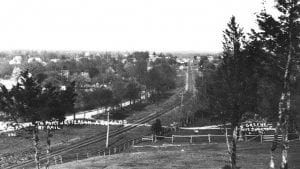
Looking east, center: The Long Island Rail Road tracks lead to Port Jefferson and Echo. Sheep Pasture Road is pictured left of the rails, Cedarwold Farm is right. Photo by Arthur S. Greene, from the Kenneth C. Brady Digital Archive
Reeve came to Port Jefferson Station in 1886 and quickly became well known among its community members. Besides working as the overseer at Darling’s farm, Reeve also ran the dairy’s milk route, which put him in almost daily contact with local residents.
Following Darling’s death in 1887, Reeve leased the farm from the Darling estate, later purchasing the property from the guardian of Darling’s daughter. Now the owner of a dairy that he had managed for years, Reeve gave his property a distinctive name, Cedarwold Farm, the “wold” an English term for an open, hilly area.
Not limiting himself to dairying, Reeve grew potatoes and turnips at Cedarwold, harvested ice from its pond and took in boarders. He also rented portions of the farm to groups that held outdoor events on the property. The location was especially popular among officials of the Long Island Rail Road who traveled to Port Jefferson by train, capping their outings with clambakes at Cedarwold.
Active in local affairs, Reeve was a member of Port Jefferson Lodge No. 627, Independent Order of Odd Fellows, the Port Jefferson Presbyterian Church, the Echo Progressive Society and the Port Jefferson Gun Club. He had also served as a deputy sheriff in Echo and as a trustee of the Echo Public School.
Reeve died on June 7, 1908, and was buried in Port Jefferson’s Cedar Hill Cemetery. His widow later moved to Connecticut to live with her daughter, Mrs. John Bossen.
Besides a natural pond, Cedarwold Farm included an icehouse, woodlands, fruit trees, a farmhouse, barns and outbuildings. Photo by Arthur S. Greene, from the Kenneth C. Brady Digital Archive
Cedarwold Farm was sold in 1910, changed hands several times over the years and had various uses. Portions of the property were once occupied by a sand mine, an asphalt plant, a turkey farm and a landscaping business, but more recently by now idle Lawrence Aviation Industries, a manufacturer of titanium sheeting for the aeronautics industry.
Reeves Road, which connects Port Jefferson’s Main Street with Sheep Pasture Road, is a reminder of Ebenezer Reeve, his idyllic farm and Long Island of yesteryear.
Kenneth Brady has served as the Port Jefferson Village Historian and president of the Port Jefferson Conservancy, as well as on the boards of the Suffolk County Historical Society, Greater Port Jefferson Arts Council and Port Jefferson Historical Society. He is a longtime resident of Port Jefferson.
Amongst the Middle Country Public Library’s many historical artifacts are a few that explain just how far the area has come from its pastoral roots. The picture and story below comes courtesy of a collaborative effort among the librarian staff.
Over the years, a variety of land developers purchased acreage in the Centereach area even as far back as 1896, despite its distance from New York City.
It took until the 1940s and 1950s for construction to begin in earnest.
Shortly after WWII, the Ulrich family developed Cedarwood Park on the north side of Middle Country Road in the vicinity of Elliot Avenue, Lake Grove. Roads were put in and building lots surveyed and improved. The lots sold for $250 each with a down payment of just $10.
The rural landscape of Centereach began to change dramatically in the middle of the 20th century when the Kaplan firm began to build low-priced homes in a development named Dawn Estates. Homes in this development sold for $7,000.
While the Kaplan brothers were among the first developers, the Krinsky Organization followed them with an even larger project. Fifteen hundred homes were to be built on a 400-acre site, but there were concerns about this project from the start.
Doubters cited its remote location and the difficulty of obtaining necessary public utilities in what was considered an isolated area. These worries were soon overcome when the Krinsky Organization created its own water company with the capacity to serve 10,000 families.
In addition, the Long Island Lighting Company agreed to extend its gas lines more than six miles beyond the existing distribution limit, bringing in electricity to serve the new homes.
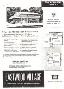
On Sept. 6, 1953, the front page of the New York Times real estate section featured a picture of the new Eastwood Village exhibit home with its raised-hearth fireplace and its combination living-dining-kitchen area.
While the first year’s sales were slow, within five years 1,250 homes had been sold. The prices for these homes ranged from $9,990 to $13,500.
In 1954, Eastwood Village became a multiple builder venture as other builders erected models on already improved building sites. By 1958, 2,500 homes had been sold in the development. Due to expanding job opportunities and the availability of larger houses on bigger sites, increasing numbers of people flocked to the area.
A study by Klein and Parker Realty in 1954 indicated that 60% of those looking at Eastwood Village came from Queens and Nassau, 20% from Manhattan and the remainder from other boroughs and New Jersey.
It has been said that so many people came to Centereach from New York City that it became known as “a portion of Brooklyn in Suffolk County.”
In 1957, the American Institute of Architects selected Hausman & Rosenberg’sEastwood Village model as a winner in the annual “Homes for Better Living” competition. Cited for its architecture and original design, the home won the award in the A.I.A’s Class A category for merchant-built homes under $15,000.
With the influx of new residents came the need for more services. The first supermarkets in the area were Acme Supermarket, Hills, A&P and the Blue Jay Market. Benkert’s of Centereach and Smiles 5&10 became favorite haunts.
In 1963, the Prudential Movie Theatre made its debut and the following year, Suffolk Federal Savings moved into its new headquarters on the south side of Middle Country Road. As a variety of stores, shopping centers and businesses appeared, the remaining farms began to fade from the landscape.
The 400 acres of land described as “a wilderness covered with heavy timber” purchased in 1790 by Isaac Hammond of Coram for 100 pounds sterling ($250) has evolved into the largest Hamlet in the Town of Brookhaven (Three Village Herald, July 15-22, 1977).


 Near the top right of the image, we can see the New Village First Congregational Church prominently featured in white, just south of the Fairgrounds. It was such a major landmark that it needed no caption. The steeple, front door and footpath are skillfully embroidered in. Homes of many residents (Overton, Emery, Olsen, Ulrich, Duffield, Campbell, Moen, Scudder and Alvin Smith, Bertram, to name a few) are painstakingly labeled along with many prominent businesses.
")


 Doubters cited its remote location and the difficulty of obtaining necessary public utilities in what was considered an isolated area. These worries were soon overcome when the Krinsky Organization created its own water company with the capacity to serve 10,000 families.

