A small taste of history: 1937 Centereach Bird’s Eye View

Amongst the Middle Country Public Library’s many historical artifacts are a few that explain just how far the area has come from its pastoral roots. The picture and story below comes courtesy of a collaborative effort among the librarian staff.
This beautifully embroidered map was gifted to Middle Country Public Library, and is part of the Heritage Collection, the library’s local history archives.
It shows a detailed and unique view of Centereach as it stood in 1937. Oriented in a west to east view from top to bottom, we can see the landmarks and homesteads that residents would visit and pass by daily.
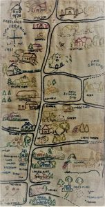 Near the top right of the image, we can see the New Village First Congregational Church prominently featured in white, just south of the Fairgrounds. It was such a major landmark that it needed no caption. The steeple, front door and footpath are skillfully embroidered in. Homes of many residents (Overton, Emery, Olsen, Ulrich, Duffield, Campbell, Moen, Scudder and Alvin Smith, Bertram, to name a few) are painstakingly labeled along with many prominent businesses.
William Tobin’s “Ontheway” Rest, located on the northwest corner of Middle Country Road and Stony Brook Road served as a gasoline station and featured a lunch stand that Mrs. Tobin ran on the adjoining property.
Other establishments depicted include the barbershop, the grocery store, Homeside Nursery, the lumber yard and Carl’s Tavern, along with the Wilkinson, Williams, Moller and Murray farms.
If you look closely, a hen and her chicks are carefully stitched in, foraging about the Wilkinson’s farmyard. The fire house, fair grounds, and schools (both the existing and proposed new school sites), the Parsonage and Parish Hall are all here.
Streets are not labeled, but we know that Middle Country Road runs from top to bottom down the center of the panel and we can see where paving is incomplete on the right margin (the north side of the map). The New Village Congregational Church which stands today on Middle Country Road just west of Elliot Avenue and residences such as the Henry house help us determine the location of other streets.
We know that the Henry homestead was located at the corner of Middle Country Road and North Washington Avenue. We can also see William Wortley’s gas station which was situated on the south side of Middle Country Road opposite Wood Road, where the barbershop stands embroidered with the traditional red and white pole.
For an entertaining treasure hunt, take a look to discover what other family names and landmarks you can find. More names and places can be found on this map than we could list here. Have fun!


