Tags Posts tagged with "Rising Sea Level"

Rising Sea Level

An eroding bluff at Long Beach has been stabilized by constructing a stone seawall at the bluff’s base. The bluff has been terraced to capture material that rolls down from the top and can be planted with vegetation that will help stabilize it. Photo from R. Lawrence Swanson

By R. Lawrence Swanson

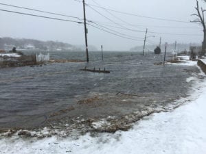
Much has been proposed, written, and even implemented, to sustain, armor, adapt, make resilient and conserve the low-lying areas of Long Island’s South Shore since Hurricane Sandy five years ago. That coast is vulnerable to extensive inundation by accelerated sea level rise, the vagaries of storm surges and climate change. Indeed, there are core areas that now flood regularly on the semi-monthly spring tides.

The North Shore of the Island has been largely neglected in the sea level rise/storm surge discussions and planning even though it is equally vulnerable to these processes. The entire geomorphology of the North Shore is subject to change with or without anthropogenic intervention. The challenge is to be able to manage this change so that the environmental services — harbors of refuge, beaches, wetlands, fisheries, aesthetics — provided by the complex, precarious topography of the North Shore remain functionally stable for the region, communities and private interests.

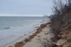
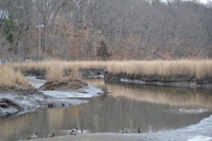
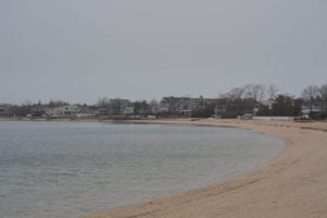
Much of the North Shore is composed of unconsolidated morainal bluffs — many 50 feet or higher — accompanied by down-current cobble barrier beaches. These spits form the small pocket bays and harbors that are the locations of historic settlements. They provide refuge for people and marine ecosystems from the energy of waves and storms. The beautiful pocket bays of Mount Sinai, Port Jefferson, Stony Brook, Northport, Huntington, Cold Spring Harbor and Oyster Bay are now the cultural centers of the North Shore.

The protective spits that form these bays are fed by erosion of the adjacent coastal bluffs. In order for the pocket bays to be maintained, spits must have a sufficient sediment supply to overcome erosional forces and sea level rise, which is currently increasing at about 1.5 feet a century in Long Island Sound, but undoubtedly will accelerate here and globally. The general process is that the bluffs are undercut at their base or toe by waves and extreme tides. This undercutting will become more severe as sea level rises and we experience greater and longer lasting storm surges in the coming years. The bluffs then slump — about 2 feet per year — creating new beach material, some of which is transported by littoral (near-shore) currents to create and sustain the barrier spits. The small beaches at the toe of the bluffs reduce the wave run-up and thus bluff erosion.

“The North Shore of the Island has been largely neglected in the sea level rise/storm surge discussions and planning even though it is equally vulnerable to these processes.”

— R. Lawrence Swanson

Construction of seawalls for which there is increasing demand along the bluff faces hinders these natural processes. Beaches fronting the bluffs will disappear so that waves will be beating directly on the seawalls. Little material will be available for transport to maintain the barrier spits with rising sea level. Those spits will then be subject to overwashing — perhaps exposing the embayments behind continuously to the open waters of the Sound.

What can be done in the way of resiliency to preserve the character of the North Shore and yet also protect individual properties on the Sound — both those on the cliffs and those on the barrier spits? Is hardening the bluffs and beaches at great expense the answer? Do we let nature take its course? Do residents on the barrier beaches have rights to the sediment of eroding cliffs in much the same way that downstream California claims rights to Colorado River water? If hardening of bluffs is allowed, will there be enough sediment at the toe to maintain a beach to reduce wave run-up?

New York State needs to examine this issue and develop guidance that works for all. Current policies are confusing and perhaps conflicting. This is a regional issue that cannot be solved property by property or even on a town-by-town basis.

With the state of development on the North Shore, some form of intervention or adaptation is probably required; nature cannot be left totally unchecked, given the grim climate projections for this coming century. Extensive hardening of the shoreline is equally unpalatable. There are negative downstream effects from almost all anthropogenic solutions. We need to understand and minimize them. Once started, hardening will eventually result in entombing us, totally eliminating the natural beauty and functionality of the North Shore that we enjoy. Perhaps there are softer forms of resilience that will allow preservation of natural processes yet significantly reduce the anticipated severe erosion from wind, rain, accelerated sea level rise and climate change. We need to find those techniques and implement them consistently.

In the meantime, there are zoning measures that can be practiced that will reduce erosion of these steep coastal faces — establish respectable setbacks, reduce or eliminate clearing, minimize variances resulting in overbuilding and consider downstream impacts of stabilization measures.

Long Island’s low-lying South Shore is at risk to the negative impacts of storm surge, sea level rise and climate change and much attention is being given to it. The North Shore, while seemingly elevated from these impacts, is not. Because its steep coast consists of unconsolidated sediments, it will experience extensive erosion. We need to understand, plan for and implement regional adaptive measures to reduce potential adverse effects to assure resilience of this vulnerable coastal environment.

R. Lawrence Swanson is the interim dean and associate dean of the Stony Brook University School of Marine and Atmospheric Sciences.

Photo by Rita J. Egan

Sills Gully Beach, Shoreham:

Sills Gully Beach in Shoreham is a prime example of erosion due to storm events, according to Brookhaven Councilwoman Jane Bonner (C-Rocky Point). “When you harden the shoreline by constructing hundreds of linear feet of vertical retaining walls or bulkheads, you create a condition where the energy stored in the waves caused by tidal surge and storm events hits up against the hardening structure and reflects back to the Sound,” Bonner said. “These reflected waves cause scour at the base of the bulkhead and a loss of sand from the beach. To minimize this impact, both the New York State Department of Environmental Conservation and the town require armor stone, big rocks, in front of any bulkhead to dissipate the reflected wave surge, reducing the impact that bulkheads have on the beaches.” According to the councilwoman, bulkheads that were constructed in the past “increased the rate of erosion but also separated the beach from its natural sand source.” The practice led to either a narrow or non-existing beach during high tide. With recent changes of bulkheads being moved landward or reducing their elevations, plus the installation of armor stones, erosive impacts have been reduced, and “the beaches tend to be wider and more resilient to storm events.”


Photo by Rita J. Egan

Port Jefferson Village:

Port Jefferson was originally known as Drowned Meadow because the area that now comprises most of the commercial district was a marsh that flooded every high tide, according to the book “Images of America: Port Jefferson,” written by Port Jefferson library staffers Robert Maggio and Earlene O’Hare. They wrote, “That flooding, and the steep hills and deep ravines that surrounded the marsh, made farming difficult, and the village grew slowly. In fact, by 1800, there were only a handful of houses.”


Photo by Maria Hoffman

Setauket Harbor:

In the last decade, Shore Road along Setauket Harbor has flooded approximately a half a dozen times a year, which is more than in the past due to astronomical tides. “All coastal communities will be increasingly impacted by rising sea level, and sea level rise goes hand in hand with climate change,” George Hoffman of the Setauket Harbor Task Force said. “One way to identify the areas that will be impacted is to look at the areas that are now impacted by storms and astronomical tides. All the low-level shore areas in the Three Village community are the most vulnerable. And, they tend to be the areas that we like to go down to, along the shore, such as beaches and docks and harbor areas. It is projected that in the next hundred years as sea level continues to rise that we will see portions of Route 25A flooding during storm events that we haven’t seen before.”


Photo by Rita J. Egan

Nissequogue River, Smithtown:

According to Jan Porinchak, educator and naturalist, the Nissequogue River watershed would be threatened by rising sea levels due to climate change. The river consists of two main branches that start near the southern boundaries of the town in Hauppauge, and then the water flows into the Sound. “Rising sea levels will drown out the native marsh grasses which dissipate wave action and anchor the sediments comprising the shoreline,” Porinchak said. “With the marsh grasses such as Spartina removed, areas further inland would be threatened with shoreline loss from erosion.” Erosion can also have a negative impact on marine species. “With rising sea levels compromising marsh land vegetation, salt water can reach the roots of non-salt-tolerant woody plants further inland, which kills those plant species,” he said. “This creates a domino effect, resulting in yet more erosion when the roots of those plants are eliminated. Increased sediment from these eroded areas will wash into the Nissequogue and similar ecosystems. This sediment can negatively impact shellfish and other marine species, and fuel algae blooms to the widespread detriment of the marine food web.”


Photo by Rita J. Egan

Long Beach, Smithtown:

Visitors to Smithtown’s Long Beach, a narrow land spit, will find an artificial berm to keep stormwater out during the winter. Many of the private roads slightly east of the town beach experience flooding when it’s high tide. Larry Swanson, interim dean of the School of Marine and Atmospheric Sciences at Stony Brook University, said the cause of the problem is the disruption of sediment due to a combination of rising sea levels and homeowners building sea walls to protect their property. “Long Beach is a spit that needs sediment supplied from the erosion of the bluffs of Nissequogue,” he said. “There are places where the supply is somewhat diminished to maintain sufficient elevation, perhaps where currents are stronger than elsewhere water can overflow.”


Photo by Rita J. Egan

Asharoken, Huntington:

The incorporated village of Asharoken in the Town of Huntington provides the only essential land access way contacting the Eaton’s Neck peninsula to Northport, with its Asharoken Avenue. Due to hurricanes and nor’easters, the Long Island Sound side of the peninsula has experienced moderate to severe beach erosion. In 2015 the Asharoken village board took into consideration a U.S. Army Corps of Engineers-backed proposal to replenish the community’s eroding beaches. The plan consisted of creating a berm and dune system with groins on the northwestern end of the project area. The area includes properties on the Long Island Sound side of Asharoken Avenue. However, in January Asharoken officials voted to bring an end to the restoration project after many residents rejected part of the plan that included creating public access points at certain private properties, which would leave residents liable for any injuries or mishaps that happened when the public was on the shoreline of the property.