
Coastal communities on Long Island face a monumental challenge in the century ahead that will determine the fate of the most inhabited island in the United States.
Sea level has risen by about a foot in the New York metropolitan region since the start of the 20th century, and the pace is accelerating, according to the New York City Panel on Climate Change in 2015. According to NASA, the last three decades are the warmest 30 years of the last 1,400. The U.S. Environmental Protection Agency attributes sea level rise to global warming caused by greenhouse gases released in the atmosphere from burning fossil fuels.
Despite the fact we still enjoy four seasons in New York and have endured more than one snowfall this winter, evidence of climate change is here. While our weather may not seem to be changing significantly, our climate is, and with that comes an array of issues.
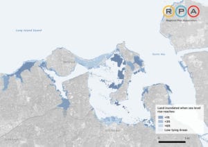
Long Island, and the New York metropolitan region as a whole, is uniquely vulnerable to the dangers presented by climate change, especially accelerated sea level rise. The New York metropolitan area has about 3,700 miles of coastline and is home to about 23 million people. In December 2016, an independent urban research and advocacy organization released a detailed study on the effects 1, 3 and 6 feet of sea level rise would have on Long Island, among other areas.
“I would say on the whole people are not responding to this as urgently as they need to or as seriously as they need to,” Rob Freudenberg, vice president of energy and environment for the Regional Plan Association said in a phone interview. Freudenberg oversaw the production of “Under Water,” RPA’s report released in December, which provides a chilling look at the future of Long Island. “It’s very hard in a way to kind of paint the picture that nobody has lived yet,” he said. “Our data and maps try to show people where these rising sea levels are going to affect them, but until people live that, it just doesn’t hit home.”
The report details the consequences for Long Island when — not if — sea levels rise by another foot, a threshold that could be reached as soon as the 2030s. More than 7,000 South Shore residents would be permanently flooded should that occur. The South Shore faces a far more imminent threat than the North Shore. However, Freudenberg said the North Shore will have similar issues to worry about around the turn of the next century. He attributed the differences in vulnerability to the North Shore’s rough highlands, which will be able to sustain sea level rise for longer, compared to the South Shore’s bays, beaches and wetlands, which could face threats as soon as in a decade.
“The South Shore will really need to start making plans to change development and how they do things today,” Freudenberg said. “The North Shore has some time but they should be thinking about it. Ideally what we’re recommending for municipalities to do is take a look at these numbers, take a look at where these areas are in the communities and start thinking about how they would plan for them as these numbers come.”
The RPA is not the only entity anticipating hazardous sea level rise around the metropolitan area in the coming decades. In February, New York State adopted official sea level rise projections based on peer-reviewed research of scientists in the hopes of helping state agencies and coastal communities prepare to fundamentally change their future plans for vulnerable lands.
“I would say on the whole people are not responding to this as urgently as they need to or as seriously as they need to.”
— Rob Freudenberg
“New York is already experiencing the impacts of our changing climate in the form of severe storms and weather events, and our sea levels are rising about two times faster than the global average,” New York Department of Environmental Conservation Commissioner Basil Seggos said in a statement.
The state’s adopted projections call for between 2 and 10 inches of sea level rise by the 2020s, 8 to 30 inches by the 2050s, 1 to 5 feet by the 2080s and up to 6 feet by 2100.
RPA’s projections follow a similar arch, though the report suggests those hurdles can be cleared much sooner. Between 3 and 6 feet of sea level rise would cause about 40,000 people living on Long Island to be permanently inundated with water. At an increase of 6 feet, about 165,000 Long Islanders would need to live elsewhere and about 20 percent of the region’s power-generating capacity would be threatened. With 3 feet of sea level rise, more than half of LaGuardia Airport could be permanently flooded.
“We built in places that in hindsight we should not have built in — low-lying areas that are meant to be temporarily flooded with water,” Freudenberg said. “The good news is that sea level rise isn’t happening at a destructive rate tomorrow. We have time to plan in places like the North Shore where geography gives us a further advantage, so we have even more time to plan. That being said, we need to be making decisions today to ensure the protection, or if we have to leave some of these areas, we have to start laying out those decisions today and planning for it. That’s kind of what we encourage municipalities to do, not to hide their heads in the sand and wait until the water is here. We need to think proactively about this.”
The report laid out a few options, though RPA expects to release another report with a wider range of potential actions and solutions in the coming months. For now, pumping more sand onto beaches or constructing higher sea walls around communities and infrastructure; elevating structures; and phasing out new development and subsequently beginning the process of relocating resident’s and business from vulnerable areas are the three responses RPA has suggested — none of which would be easy or cheap.
“I don’t think we’re making the decisions that we need to today and I don’t think we have enough reliable sources of funding to make those changes.”
— Rob Freudenberg
Freudenberg called on local municipalities to begin planning for the inevitable. He said the biggest obstacle is establishing a reliable revenue stream to begin the process of adapting the region for a soggy future.
“I think we’re not adequately prepared for that,” he said. “I don’t think we’re making the decisions that we need to today and I don’t think we have enough reliable sources of funding to make those changes. Like we say in the report, there’s 3,700 miles of coastline in our region — we are not going to be able to build a wall to protect all of that. We’re going to have to make choices about where we do protective measures versus where we do the other end of the spectrum, which is where we have to leave, or retreat areas. Either way we don’t currently have enough funding to do any of those.”
Freudenberg also warned rising sea levels will make the region more vulnerable to storm surges in the event of another Hurricane Sandy. In a 2015 op-ed in The New York Times, Stony Brook University professor of physical oceanography at the School of Marine and Atmospheric Sciences Malcolm Bowman expressed a similar concern.
“In the future, relatively modest storms riding on an ever-increasing sea level will do as much damage as rare, once-in-a-century storms do now,” Bowman wrote.
Freudenberg made sure not to understate the road ahead for those who live and work on Long Island.
“It’s going to be the biggest investment we make in our region over the next 50 to 100 years,” he said.


