Tags Posts tagged with "Ali Nazir"

Ali Nazir

Councilmember Jonathan Kornreich (D-Stony Brook) questions the town’s mapmaker during a public hearing on Thursday, Sept. 29. Screenshot from the town website

The Town of Brookhaven’s controversial redistricting process concluded on Thursday, Sept. 29, after the Town Board voted unanimously to approve the latest proposed map.

The Town Board, which has a 6-1 Republican majority, took over the redistricting process after an appointed redistricting committee failed to find agreement on a draft proposal. Days after the committee formally disbanded, Town Supervisor Ed Romaine (R) presented his own map. For more on this story, see “Brookhaven officials react to latest redistricting proposal” (TBR News Media website). 

Councilmember Jonathan Kornreich (D-Stony Brook) kicked off the public hearing with a forceful line of questioning of the town’s designated mapmaker, David Schaefer of Schenectady-based firm Skyline Consulting. 

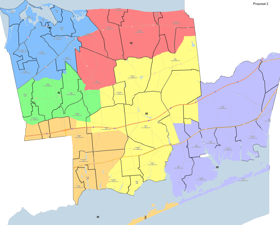
Kornreich pressed Schaefer on a range of subjects, such as his familiarity with the hamlets throughout the town. He also inquired about how Schaefer arrived at an original determination to split Port Jefferson Station and Terryville between Council Districts 1 and 2, and why he decided to move most of Ridge into CD4.

Responding, Schaefer said that he created the initial maps solely to bring the six council districts into roughly equal populations. “The first draft that I submitted is all population driven,” he said.

Following Kornreich’s line of questioning, residents pressed their representatives on the Town Board repeatedly over concerns that arose throughout the redistricting process and the alleged inequities in drawing the district lines. 

Ira Costell, a resident of Port Jefferson Station, argued Schaefer’s approach was unproductive, reducing redistricting to an analytic method while ignoring its impact on communities of interest.

“There’s more than just standard deviations and numbers at play here,” Costell said. “There’s people, there’s communities, there’s interests, and there’s fairness at stake here, and I don’t see a lot of it in what the mapmaker initially did.”

‘Despite the hideously flawed process that led here, I think in the end we’ve created a map that’s got some compromises, and it’s got a little something for everyone to be unhappy about.’

— Jonathan Kornreich

Costell further railed against the committee process, saying, “The hearings were poorly advertised, they were chaotic, they were confusing, they were marked by a lack of support information from the town, which resulted in maps that just appeared out of thin air.” He continued, “What does seem transparent, however, is the majority on this board seems poised to ignore the clear will and desires of the voters who did speak out.”

Terryville resident Lou Antoniello suggested Schaefer was not being truthful during his remarks. He added that tampering with district boundaries may affect future redistricting procedures.

“While the map that this board put together is light-years better than the original map, which cut out a huge chunk [of Terryville from CD1], it’s still cutting — cracking — Council District 1,” he said. “That sets a dangerous precedent for the future.”

Members of the redistricting committee also attended the public hearing. Among them was Gail Lynch-Bailey, who had served this year and in 2012. She referred to the two initial maps which split Port Jefferson Station and Terryville as a ploy to divert the public’s attention away from alleged gerrymandering in Council District 4. This district includes the racially and ethnically diverse communities of Coram, Gordon Heights and North Bellport.

“Once the public realized the commission had had no input into them, the maps were readily recognized by many for what they were: diversions, bait-and-switch tactics, ‘pay-no-attention-to-the-man-behind-the-curtain’ maps intended to focus attention on the northern CDs instead of what was going on for CD4,” she said. “This ruse was, and still is, unconscionable.”

Also making an appearance was Ali Nazir, the Republican co-chair on the redistricting committee. He defended the movement of mostly white Ridge into CD4, citing the hamlet’s longstanding ties to the Longwood community.

“Despite rhetoric of the contrary, Ridge has always been in Council District 4,” Nazir said. “Ridge has a long history with the Longwood community, and to arbitrarily excommunicate them from the Longwood community is quite frankly wrong.”

Port Jefferson Station and Terryville, however, remain mostly united within the boundaries of Council District 1. Kornreich, who voted with the majority, justified his vote, saying this map would not split minority communities or dilute their votes.

“We negotiated in good faith, and the supervisor fulfilled his promise to keep Gordon Heights and North Bellport together, not to dilute the minority vote, and in good faith, I will support the agreement we made,” Kornreich said. “Is it an ideal map? No. Is it a map that I were to draw? Of course not. But when you’ve got one Democrat and a row of Republicans, you tell me what level of political power you have.”

In concluding his remarks, the CD1 councilmember said the final map reflects a series of compromises. “Despite the hideously flawed process that led here, I think in the end we’ve created a map that’s got some compromises, and it’s got a little something for everyone to be unhappy about,” he said, adding, “I hope that we can get to work and solve the real problems that face our town.”

No other board member spoke during the hearing. Following the vote, a droning cry rained from some in the audience, the dissidents shouting, “Shame on you, shame on you.” 

It remains unclear whether the map will face challenges in court or whether those challenges could hold up given the bipartisan outcome.

The Town of Brookhaven seal. Photo from the town website

Following a contentious virtual meeting on Monday, Sept. 12, the Brookhaven Redistricting Committee failed to reach a compromise on a proposed map, sending the redistricting process to the Brookhaven Town Council.

The committee voted on three maps during the meeting, none of which received the six votes necessary to adopt an official proposal. There was significant controversy leading up to this meeting. Despite this, all eight members and the committee’s mapmaker, David Schaefer, were present.

However, members calling attendance seemed to be the only unanimous outcome of the night, as the three Democratic appointees clashed with their Republican and Conservative Party counterparts throughout the evening.

The meeting got out to a rocky start after an unsuccessful motion to adopt an agenda. Schaefer then presented three maps that the committee requested during the previous session.

Schaefer first presented a “map of least change.” This map addressed only Council Districts 2 and 6, the two districts whose populations fall outside the 5% deviation allowable under the Town Code. After a vote, this map failed 3-5, with Democratic appointees Rabia Aziz, George Hoffman and Gail Lynch-Bailey voting “yes” and all others voting “no.”

Schaefer also presented a map that loosely follows the proposal of Coram resident Logan Mazer. On the whole, the Mazer map was viewed favorably during the public hearings. However, this proposal was ultimately shot down by another 3-5 vote, with the same committee members voting for and against it.

Schaefer’s final presentation was a map that followed the boundaries of Proposal 2, one of the two original draft proposals which met fierce opposition during the public hearings. With some adjustments to the boundaries of CD1 and CD2, this new map kept much of Proposal 2 intact.

In the face of this public opposition, the map was the highest vote-getter, with a 5-3 vote count — one vote shy of formal adoption by the committee. Ali Nazir, Edward McCarthy, Delilah Bustamante, Krystina Sconzo and Chad Lennon voted “yes,” with the entire Democratic caucus voting it down. 

In a phone interview, Lynch-Bailey confirmed that the redistricting committee officially disbanded the following day around noon after Nazir and Aziz, the co-chairs, could not reach a compromise. Failing to adopt a proposal, the committee sends the process to the Town Council. 

During a Town Board meeting Tuesday, Sept. 13, Supervisor Ed Romaine (R) discussed some of the criteria he will be looking for in the new map. He said he hopes to achieve an equal population distribution across council districts, keep minority communities together within district boundaries and reduce the number of split communities. The Town Board must adopt new council district outlines by Dec. 15. 

The supervisor expects a new map to be available on the town website by next week. A public hearing on the matter will be held at Town Hall on Thursday, Sept. 29, at 5 p.m. 

Visit our website to follow features on this important issue:

Brookhaven Redistricting Committee member says residents must stay engaged

George Hoffman, a member of the Brookhaven Redistricting Committee, congratulated the residents who have mobilized throughout this process, but he believes their work is unfinished. Photo courtesy Hoffman

The redistricting committee recently approved the creation of three new draft maps, one of which you voted ‘no.’ Could you briefly explain your ‘no’ vote?

Ali Nazir, the co-chair, requested taking one of the first maps — which created all this controversy — and refining it by putting Council Districts 1 and 2 together but leaving everything else as it is. 

Ali’s resolution solves the issue of Mount Sinai and Terryville. Still, it keeps [Council District] 4 the way the mapmaker drew it. I voted ‘no.’ Rabia [Aziz] voted ‘no.’ Gail [Lynch-Bailey] had left because she had to go to a civic meeting by that time. The rest of the [members] voted ‘yes’ [for a 5-2 vote] and that’s very concerning.

What is your message to those who have successfully resisted the first two draft maps?

I congratulate the communities of Mount Sinai, Terryville and Port Jeff Station because they mobilized quickly to preserve their communities of interest. They wanted to stay with the original council district boundaries we have had for 20 years, so I would not minimize their involvement. And it was a very personal involvement: they were defending their communities and protecting their backyards. If they hadn’t come out in such strength, maybe the majority on that commission may not have put it back. But I think the bigger goal is still to crack CD4.

In your eyes, does the transfer of Ridge into Council District 4 constitute an act of partisan gerrymandering?

Yes, and I think it may even violate the [John Lewis] Voting Rights Act. It’s pretty clear that Ridge is a solid Republican-leaning area. To put it into a diverse community solely because it will affect the outcome of that district, I think, is certainly the definition of gerrymandering.

With a few adjustments to Council Districts 1 and 2, Hoffman said Proposal 2 (above) is still in play. Map from the Brookhaven Redistricting Committee’s website

How can concerned residents help to deter an unfavorable redrawing of CD4?

To all the residents of Brookhaven, we should be concerned. They should care about their own community — it’s important to fight for your own community of interest — but help as much as you can to have a fair and balanced redistricting townwide because what’s going on is not fair and it’s not balanced. My recommendation would be that everyone has to stay engaged.

What changes are you looking for in the coming weeks?

I think all six districts have a right to stay close to what they are currently. I recognize that Council District 2 is down a couple of thousand in terms of population, so you need to balance that. Council District 6 had a lot of growth, so you do have to remove some of the people there. But there shouldn’t be mischief in doing that.

What is your reaction to the committee’s recent meeting with David Schaefer, the mapmaker?

Last night [Aug. 18], we met with the mapmaker for the first time in a month and a half. We should have met with him at the outset, or at least after the first six public hearings. Because so few people showed up at the initial hearings, he should have at least asked us what our vision or goals were for the first map. To do a map without even talking to us is like an interior decorator designing your house without consulting you. 

I don’t think he’s politically motivated. I think he has good skills as a demographer and was pretty candid with us. But I do believe that he’s responding to some instructions. I think he’s data in/data out, and I don’t think you can do redistricting that way. Maybe he’s too much on the statistical side and not sufficiently understanding of communities.

Isn’t that the real purpose of redistricting? To balance out the populations but don’t destroy communities.

What is your understanding of the history of councilmanic districts in the Town of Brookhaven?

For years, the town used to elect its council people at large. There were always seven members — six board members and a supervisor — but they ran townwide. What happened was that they were not very responsive to local communities. You could vote against a community and still survive if you had the rest of the town, and it got very bad. 

A civic network was formed called ABCO, the Affiliated Brookhaven Civic Organizations, and it became huge. They would do a meeting and have dozens of civic organizations throughout the township meet to talk about how unresponsive the town was to their needs. It culminated in a movement for a referendum for council districts to divide the Town Council into six districts based on regional community interests. It went to a vote. The community was very organized, and they prevailed.

Council District 4 was seen as the most diverse district in the town. People saw it as the district that probably would be most successful at electing a diverse candidate, and both parties understood that. That was 2002, so for 20 years now, we’ve lived under these districts, more or less. 

I’m a bit taken aback by what’s happening in this redistricting. It’s pretty clear to me now that the goal is to change CD4 into a more favorable district, almost partisan gerrymandering to help the incumbent there [Councilman Michael Loguercio (R-Ridge)]. 

What are the risks of an overly analytical redistricting process that neglects the complex realities on the ground?

This is sort of a digression, but it has been over 75 years since splitting India into India and Pakistan. The map was done by a British guy who never went to India and just drew a straight line down the middle of the country following rivers, and over a million people died because the partition was done without any understanding of communities.

You can’t just do demographics without understanding the consequences of your mapmaking. I think [the mapmaker] has been much more on the statistical side, and I would like for the map to reflect a keener understanding of the communities of Brookhaven.

Screenshot taken from the Brookhaven Town website

The Brookhaven Redistricting Committee met Thursday, Aug. 18, in a virtual meeting with the committee’s mapmaker, David Schaefer. 

This meeting marks the first time throughout this process that the eight-member committee has met with the mapmaker. Before speaking with the various committee members, Schaefer gave his rationale for two draft maps that generated significant public interest and opposition. 

For Schaefer, political redistricting aims to balance populations across council districts. “Equal population is the reason we’re doing redistricting,” he said. “This is about one person-one vote, and all other criteria are secondary to that.”

Aside from this primary condition, Schaefer said that the New York Municipal Home Rule Law states several additional criteria that factor into the mapmaking process. Among these items are drawing maps that promote political participation of racial or language minorities; contiguity; compactness; unifying communities of interests; and facilitating the efficient administration of elections.

George Hoffman, a Setauket resident and committee member, pressed Schaefer on the two draft proposals that have generated significant public opposition throughout this process. He asked the mapmaker whether he had received any testimony that suggested swapping Mount Sinai and Terryville between Council Districts 1 and 2.

Schaefer said that though he had read through the public testimony to familiarize himself with the issues, those suggestions did not weigh into his drawing of the original maps. He considers the two proposals as rough drafts only.

“I don’t take it upon myself to put any weight on any of the testimony, whether it’s positive or negative,” he said. “I leave that for the commission to do, and I don’t think my draft is one that the commission should accept as anything more than a first draft.” He added, “If there are changes to be made or big issues to consider, those are in the next pass of what I would do.”

Committee member Krystina Sconzo, of Mastic Beach, raised the issue of evaluating election districts versus communities of interest. She said that she would like for the committee to prioritize communities of interest.

Sconzo and Gail Lynch-Bailey, of Middle Island, both reiterated one of the frequent complaints from the public regarding the legibility and accessibility of the draft maps. They both asked for future draft proposals to present as many details as possible. 

Schaefer acknowledged the request, indicating that a detailed draft proposal is relatively simple. “I can create individual maps that have every road, most of the street names on those roads, and I can do it very quickly,” he said.

Lynch-Bailey motioned for the mapmaker to produce a map addressing the population imbalances between Council Districts 2 and 6. She said these districts are the only ones falling outside the 5% deviation allowable under town code and, therefore, the only ones requiring change. 

“I request a map that addresses just those two districts, and please put back Mount Sinai and Terryville,” she said. The motion passed the committee unanimously.

Co-chair Rabia Aziz, of Coram, cited the considerable public testimony regarding the proposed changes to Council District 4. She said that while the initial draft proposals keep the diverse communities of Gordon Heights and North Bellport within CD4, they dilute the voting power of those areas through the incorporation of Ridge into CD4.

“If you dilute the ability of people of color to be able to elect someone that has their community of interest at heart, then I think that is not in concert with what the community would want,” she said. “It should be a council district of least change.”

Aziz moved to send all of the public map submissions to Schaefer and have him produce a map that loosely follows the boundaries set forth by the Logan Mazer map. Aziz’s resolution passed the committee unanimously. For more on the Mazer map, see the TBR News Media story, “Residents, elected officials fight to keep PJS/Terryville intact” (Aug. 11).

Ali Nazir, of Lake Grove, made the final motion of the evening. He asked to produce a map that follows the boundaries of Proposal 2, currently on the website, but restores Port Jeff Station/Terryville and Mount Sinai. Nazir’s resolution passed the commission 5-2, with Hoffman and Aziz voting “no.”

Members of the committee agreed to give Schaefer at least a week to prepare the three draft maps requested during this meeting. The committee decided to reconvene in the first week of September to mull over the new maps. To watch the entire meeting (starting at 4:21:50), click here.