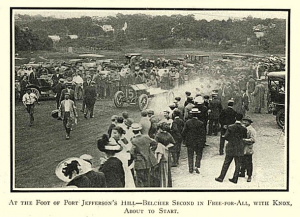
The photo shown here of the 1910 hill climb are from the Lazarnick collection, Detroit Public Library, credited to Spooner & Wells, a New York City photography company
By Robert Laravie
A 1907 two-day endurance tour by the Long Island Auto Club may have planted the seed of a hill climb event in Port Jefferson. The 1907 tour had a stop in Port Jefferson for lunch at Mrs. Smith’s house, then went on to Greenport and back to Brooklyn.
A June 30, 1910, article in The Automobile indicated that a well-known promoter and local “live wire,” W.J. Fallon, organized a hill climb which was held June 25. Sixty-seven cars were entered.
The hill climb was sponsored by the Port Jefferson Auto Club and run on West Broadway, a course of about 2,000-feet in length, with an average grade of 10% and a peak of about 15%, ending at the Belle Terre Gatehouse. The local club contact was listed as G.E. Darling.
The hill climb was divided into 16 events by cost of auto, cubic inches of engine displacement as well as a “free for all” and a few events for cars owned by local club members and residents of Port Jefferson.
The fastest time was 20.48 seconds (about 68 mph) in a Fiat owned by E.W.C. Arnold and driven by Ralph DePalma. The slowest car, 1 minute, 36.58 seconds (about 14 mph), in a Knox driven by E.B. Hawkins.
Two other clubs participated in the events, the Crescent Athletic Club and the Long Island Auto Club. Knox cars won the most events totaling five wins and the results were widely used in advertising for the cars.
Various manufacturers entered their cars in the event includingOakland, Buick, the Only Motor Car Co. (a Port Jefferson-built car), Houpt-Rockwell, Pope-Hartford, Zust and Berkshire Automobiles.
Two cars entered were owned by women, Mrs. J.N. Cuneo entered her Knox and Mrs. J.A. Ferguson entered her Lancia.
The photoshown here of the 1910 hill climb are from the Lazarnick collection, Detroit Public Library, credited to Spooner & Wells, a New York City photography company
Hawkins, the postmaster of Huntington, protested one event, claiming that the car driven by Fallon was not in fact owned for the required 30 days prior to the event.
A second protest was entered by J. Bell claiming the Knox entered by Fred Belcher in the stock events was in fact not in “stock” condition.
The hill climb was rerun on Sept. 9, 1911, and a commemorative event was staged in 1925. That event was won by a locally built car, the F.R.P. — Finley Robertson Porter.
A F.R.P. now resides in the Seal Cove Auto Museum in Mount Desert Island, Maine.
Reenactments of the hill climb took place in 2010 and 2015. There will be another event Saturday, Aug. 14, starting 10 a.m. at the Village Center. A rain date is set for the following day. For more info visit the website: portjeff.com/events/hillclimb.
Robert Laravie grew up in East Greenbush. He is a retired landscape architect, and worked for the New York State Department of Transportation on Long Island, New York City and on the Tappan Zee Bridge project in Tarrytown. He is currently a resident of Port Jefferson and has been a local conservancy member for the past six years.
'Genessee' – William K. Vanderbilt II’s 100-foot schooner,1910. Suffolk County Vanderbilt Museum Archives
The Suffolk County Vanderbilt Museum, 180 Little Neck Road, Centerport will offer a series of three lectures on Long Island maritime history beginning in August. Following the lectures, which will be given in the Reichert Planetarium, the Museum will hold book signings and offer refreshments. Tickets are $6 per person. Members are free. JOIN NOW!
“Little Known Aspects of Long Island’s Maritime History” Bill Bleyer, Author and Journalist Wednesday, August 11, 2021, 7:00 pm
This PowerPoint lecture covers the development of submarines and torpedoes, the landing of Pan Am Clippers in Port Washington, the world’s most innovative whaling captain, and more. Mr. Bleyer, a former Newsday staff writer, has written four books on Long Island history, including Long Island and the Sea: A Maritime History and Long Island and the Civil War. He is a freelance contributor to Newsday and magazines.
Willie K. and Harold S. (Mike) Vanderbilt: Gilded Age Yachtsmen Dr. Robert B. MacKay, Historian and Author Wednesday, September 22, 2021, 7:00 pm
This lecture will focus on how the Vanderbilts used their yachts for racing, cruising, and epic voyages. An avid sailor, noted author, and preservationist, Dr. MacKay is director emeritus of Preservation Long Island. Among his books are Great Yachts of Long Island’s North Shore, The Golden Age ofNewport Yachting: Between the Wars, Long Island Country Houses and Their Architects 1860-1940.
“Fire and Ice: The Loss of the Steamship Lexington” Brian E. O’Connor, Retired Attorney and Author Wednesday, October 27, 2021, 7:00 pm
For 40 years, Mr. O’Connor handled complex commercial litigation as a partner with a Wall Street law firm. He will tell the story of the Steamship Lexington – built by Commodore Vanderbilt in 1835, for service on Long Island Sound – and its tragic fire, sinking, and loss of life on January 13, 1840. The tragedy had profound legal significance, prompting Congress to enact the Shipowners’ Limitation of Liability Act in 1851, which overruled an earlier Supreme Court decision and held the Lexington’s new owner liable for the loss of cargo on board when she sank. The Lexington’s loss was also a catalyst for Congressional legislation to regulate steamboat safety.
Amongst the Middle Country Public Library’s many historical artifacts are a few that explain just how far the area has come from its pastoral roots. The picture and story below come courtesy of a collaborative effort among the library staff.
In the 10 years between 1940 and 1950, the population of Selden doubled from 847 to 1743. By 1960, it would more than double again.
Photo from MCPL
The growth of neighboring Centereach was even more dramatic; from 628 in 1940 to 3100 in 1960 and 6,676 in 1970. For many civic-minded citizens, it was time for a community library. In March of 1957, The Mid Island News announced the forthcoming opening of the “long-awaited library serving the Centereach and Selden communities.” A library board of trustees was formed and board president, Lucille Hough, began a door-to-door canvass to solicit books for the new facility.
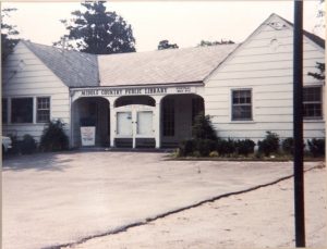
The former Nature’s Gardens clubhouse on Middle Country Road in Selden was acquired from area developer, O.L. Schwenke. A local carpenter began renovations and volunteers were requested to help catalog the books. The library was to be open 15 hours per week and managed by part-time librarian, Sadie Hallock, assisted by volunteers. By 1961, the topic of the need for a new branch library appeared in the board minutes. Suggested sites were Jericho School or the former Centereach school — neither proved possible. In 1963, when a new Centereach Post Office was built, the site of the former post office became available for rent. In June of 1963, a lease was signed for 8 Dawn Drive which would be available by year’s end. A “Stack the Shelves” drive suggested by Mr. Jones of Tinker National Bank announced that the bank would contribute $500 plus $2.00 for every new depositor over a stated period. In addition, Bernard Kaplan, Eastwood Village developer, pledged $500 to start the campaign.
Circulation figures for the library increased every year. In 1964, the first year both libraries were in operation, the circulation was 54,570. By 1967, it had risen to 176,145. In 1968, the name changed to Middle Country Public Library reflected the consolidation of the school district. That same year, the board hired Paul John Cirino as the library director.
Photo from MCPL
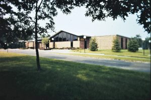
As the number of school age children surged and the school district became the fastest growing in the nation, the library kept pace to meet the needs of the increasing population. A search was begun for a suitable site of approximately three-acres with a minimum frontage of 150-feet and close to the center of population and not more than a quarter mile from Middle Country Road. In 1971, ground was broken for a new building on the corner of Eastwood Blvd and School Street and the new 19,000-square-foot building was dedicated on Jan. 30, 1972.
By 1981, the number of library cardholders had exceeded 51,000 and the annual circulation topped 500,000. Program attendance continued to rise and space for additional programming was at a premium. When the lease on the Selden Branch expired, the School District offered the unused Selden Elementary School to the library. In 1983, after remodeling the school to provide handicapped access and library furniture and shelving, the Middle Country Cultural Center at Selden was opened to the public.
An auditorium, complete with a stage and seating for almost 200, afforded a venue for community dramatic and musical a. MCPL’s 107,000-square-foot, two-building expansion made it the largest and busiest library on Long Island.
Photo from MCPL
Dynamic architectural spaces reflect the ever-changing innovative and creative activities taking place within the library, which is always looking forward to draw in new audiences and find ways to make the library an even more responsive heart of the community.
A steam locomotive is shown in August 1878 at Port Jefferson’s original LIRR depot and freight house situated west of Main Street (Route 25A). Photograph by George B. Brainerd; Photo from the Kenneth C. Brady Digital Archive.
After the Long Island Rail Road brought a branch to Northport in 1868, a group of prominent Port Jefferson businessmen lobbied for extending the north shore branch eastward to their village.
Although a leading wooden shipbuilding center in the years following the Civil War and blessed with one of the finest harbors on Long Island, Port Jefferson was surprisingly isolated for so important a village.
Going to New York City by train involved a tedious stage ride from Port Jefferson to Medford, the nearest station on the LIRR’s main line, followed by a rail trip to Long Island City and a ferry run across the East River to James Slip in Manhattan.
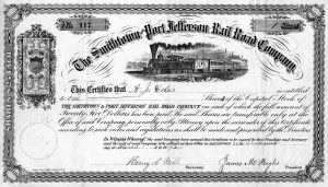
Stock certificate for the Smithtown and Port Jefferson Rail Road Company, which was absorbed by the LIRR. Photo from the Kenneth C. Brady Digital Archive
Port Jefferson Harbor often froze over during the winter and limited travel by packets, steamboats and other vessels engaged in waterborne commerce.
Hoping to make Port Jefferson more accessible and boost its economy, a committee of villagers was formed and charged with inducing the LIRR to bring freight and passenger service to Port Jefferson.
The diverse group included realtor William Fordham, publisher Harvey Markham, druggist Holmes Swezey, and tinsmith John Lee. They met regularly from 1868-1870 with representatives from St. James, Setauket, Stony Brook, and other communities where support for extending the Northport branch was strong.
Following lengthy discussion, a proposal was submitted to and accepted by the LIRR. The Smithtown and Port Jefferson Rail Road Company, organized in 1870, pledged to raise the money necessary to construct the 18-mile extension from Northport to Port Jefferson. Upon completion of the project, the LIRR agreed to lease and operate the franchise for 20 years.
Respected Port Jefferson shipbuilder James M. Bayles was elected president of the Smithtown and Port Jefferson Rail Road Company, and Robert W. Wheeler, who ran a flour/saw mill in Port Jefferson, served on its board of directors. The corporation had an authorized capital stock of $200,000, divided into shares of $25 each.
After surveys were completed, rights-of-way secured and contracts finalized, construction began on the 18-mile road. Gangs worked from 1871-1873 on separate parts of the route. The eastern, or Port Jefferson section, employed 200 men under the direction of Captain John Scully.
On Monday, Jan. 13, 1873, the first train left Port Jefferson at 6 a.m. with 24 passengers for the over three-hour, 58-mile trip to Long Island City. The fare on the inaugural run was $1.90.
The terminal at Port Jefferson, including a depot, freight house, turntable, and platform, was located on the west side of today’s Main Street (Route 25A).
The coming of the Smithtown and Port Jefferson Rail Road Company, which was absorbed by the LIRR in 1892, raised property values in Port Jefferson and eased travel to and from the village.
The railroad also brought tourists to Port Jefferson, hastened the village’s transition from a shipbuilding center to a vacationland, lessened Port Jefferson’s dependence on sea trade, and made the village a transit hub.
Kenneth Brady has served as the Port Jefferson Village Historian and president of the Port Jefferson Conservancy, as well as on the boards of the Suffolk County Historical Society, Greater Port Jefferson Arts Council and Port Jefferson Historical Society. He is a longtime resident of Port Jefferson.
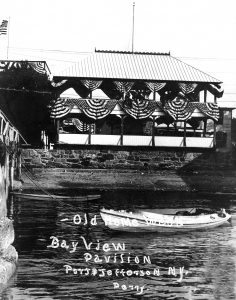
The Bay View Pavilion, left, and Wilson’s Sail Loft, right, are pictured on the waterfront off Port Jefferson’s East Broadway. Photo from the Kenneth C. Brady Digital Archive
Once a lively Port Jefferson hotspot, the Bay View Pavilion was located in the village on the north side of Water Street (East Broadway).
The building was situated on shorefront property leased from Brookhaven Town by the Ladies Village Improvement Society (LVIS) of Port Jefferson, which also funded Bay View’s construction.
The two-story pavilion was 20 feet wide and 40 feet long, open on all four sides and protected from shoreline erosion by a stone seawall.
Bounded by a small lawn on its east and west, the building was painted green and adorned with a decorative sign, “Bay View,” donated by gifted local artist William M. Davis.
Opening to the public on July 4, 1901, the pavilion soon became a village landmark and well known for its summertime activities including ice cream socials, bazaars, cake sales, band concerts, dances and church outings.
Bay View Pavilion was located on the north side of Port Jefferson’s East Broadway. Shown decorated for Old Home Week, 1911, the building was the center of summertime activities in the village. The site of the former pavilion is known today as Mary Bayles Park. Photo by Perry; Photo from the Kenneth C. Brady Digital Archive
Water carnivals were also held at Bay View’s public dock which had been built by LVIS in cooperation with the Port Jefferson Yacht Club.
During the Old Home Week celebrations of 1908 and 1911, the pavilion hosted swim meets, boat races, diving contests and other aquatic activities.
Because of its prime waterfront location near Wilson’s Sail Loft, the Harbor View Hotel, F. F. Darling and other establishments, people were drawn to Bay View where they took in the ever-changing sights, but unfortunately the pavilion was also a magnet for rowdies.
The situation had gotten so out of control by 1924 that Leopold Cordier, who ran a paint store next door to Bay View, was appointed a deputy sheriff with authority to keep order at the pavilion.
Bay View also suffered from neglect and was in such poor condition that in 1927 the Port Jefferson Business Men’s Association called for the pavilion’s immediate removal.
After the Bay View eyesore was razed, the plot where it had stood remained largely unimproved until 1943-1944 when Brookhaven Town developed the property as parkland and the Suwassett Garden Club of Port Jefferson landscaped and maintained the grounds.
The site of the former pavilion is known today as Mary Bayles Park.
Kenneth Brady has served as the Port Jefferson Village Historian and president of the Port Jefferson Conservancy, as well as on the boards of the Suffolk County Historical Society, Greater Port Jefferson Arts Council and Port Jefferson Historical Society. He is a longtime resident of Port Jefferson.
The Suffolk County Vanderbilt Museum, 180 Little Neck Road, Centerport now offers Walk and Talk Tours through mid-October.
Come for an intriguing Walk and Talk tour of the Vanderbilt Estate and gardens with knowledgeable Vanderbilt Museum educators. Learn about Warren & Wetmore’s design and the exterior architectural details of the 24-room Spanish Revival mansion – including the striking ironwork of Samuel Yellin, considered the greatest iron artisan of the early 20th century – and explore Mr. Vanderbilt’s passion for travel, marine biology, and auto racing.
“The grounds are beautiful at this time of year and the walking tour is a perfect way to be introduced to the history of the estate and collections. There is an abundance of beauty in the eclectic architecture and the unique details that reflect William Vanderbilt’s interests,” said Beth Laxer-Limmer, associate director of education.
William K. Vanderbilt II (1878-1944) spent summers at his Eagle’s Nest estate and mansion on Northport Bay between 1910 and 1944. He and his wife, Rosamond, hosted intimate gatherings and entertained well-known guests, such as the Duke and Duchess of Windsor, Pierre Cartier, Conde Nast, Charles Lindbergh, and the Tiffanys. Eagle’s Nest is listed on the National Register of Historic Places.
Created by the Vanderbilt Education Department, the tours are limited to 10 people each and are held on Thursdays, Fridays, and Saturdays at noon and again at 1 p.m. Tickets may be purchased at the door: Adults $16, seniors/students $15, children under 12 $13, members free. For more information, call 631-854-5579.
Amongst the Middle Country Public Library’s many historical artifacts are a few that explain just how far the area has come from its pastoral roots. The picture and story below comes courtesy of a collaborative effort among the librarian staff.
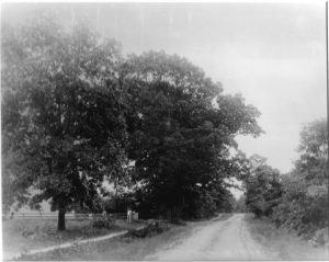
Driving along Middle Country Road today, it is hard to imagine that only 100 years ago, this busy four- lane highway with its many intersections, signs, and streetlights started out as little more than a hard-packed dirt road.
Go back 100 years more, and you’d only see a narrower, rutted path. We take our nicely maintained, hard paved roads for granted today, but it wasn’t always such a smooth ride.
Today’s network of streets and highways have their origins in simple trails which were used by people and wildlife leading to sources of water and shelter.
These paths measured only two to three-feet wide in places, but they were sufficient for the needs of the times.
Photo from MCPL
Early English settlers began to use these footpaths as they established homesteads on Long Island, widening and improving these paths, using them as cart-ways to allow for easier travel between their farms. The cart-way needed to be wide enough for a livestock-drawn cart to traverse with ease. In those days a cart would be hauled by cattle, ox, or horsepower.
Those paths were the only way to travel around Long Island until 1703, when the NY General Assembly appointed highway commissioners in King’s County (Brooklyn), Queens County and Suffolk County to direct the building and maintenance of roads “four rods wide.” The roads were simply packed earth, hardened over time by travelers.It took some time for conditions to improve, and eventually drainage systems were constructed, and logs or planks were laid across some roads to pave them. These log-covered roads were known as “corduroy roads” because of their bumpy surface.
Thirty years after the highway commissions laid out the routes, arranged rights-of-way between existing properties and physical construction took place, Long Island boasted three major thoroughfares: North Country Road, parts of which follow today’s Route 25A; Middle Country Road, now known as Route 25 or Jericho Turnpike; and South Country Road, portions of which serve as Montauk Highway.
An organized system of roads was needed for many reasons as the population grew. Though most homesteads were self-sufficient at that time, people would barter for goods and gather together to socialize. Mail needed to be delivered across the Island, and prior to the establishment of the U.S. Postal Service in 1775, England’s Royal Mail System was utilized. Before reliably passable roads were built, that mail was delivered from Connecticut by boat. It was faster and easier to travel 19 miles by water than 120 miles overland from New York City.
As the farmland was cultivated and enriched over time, it produced more than one family or village could use and farming became a burgeoning industry.
Means to transport the surplus produce was required. Farm to Market Road (also called Horseblock Road) filled this need. Farm owners would load their wagons full of fruits and vegetables to ship by rail to New York City.
The term “horseblock” refers to a block of stone or wood used to help a person climb high enough to mount a horse or to enter a stagecoach with ease. With many homes, farms and taverns located along these miles of roadway, horseblocks were a familiar sight. We call this same Farm to Market Road by its old nickname, Horseblock Road to this day.
Photo from MCPL
Through the years, several popular taverns and rest stops were located on Horseblock Road. As far back as Revolutionary times, Sam “Horseblock” Smith owned and ran a tavern at the intersection of Horseblock and Middle Country Roads in Centereach.
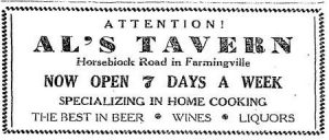
A Smith genealogy relates that on March 2, 1806 Sam sold the inn and land to Lake Grove resident, Titus Gould. It appears that part of the tavern was dismantled and moved to another location. Generations later, Alfred Elsmann ran Al’s Tavern, at the corner of Horseblock and Granny Roads. It was advertised in the Patchogue Advance of March 7, 1946 as specializing in home cooking and “the best in beer, wines and liquors,” and was a popular destination for local festivities for several decades.
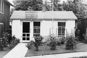
Members of the Brookhaven Town Police Department are pictured in front of 2nd Precinct headquarters on Port Jefferson’s East Main Street where they were based from 1950-1960. Photo from Beth Pranzo Collection
Alarmed by Port Jefferson’s growing descent into lawlessness, a group of concerned residents met in 1886 to consider building a lockup within the village.
Port Jefferson’s citizens were troubled by the rise in vagrancy, burglaries and vandalism in their community and disgusted with the increasing numbers of drunks on the village’s streets.
At the same time, Port Jefferson’s constables were hampered from carrying out their duties because there was no place in the village to detain persons pending their court appearance.
An attempt to fund the lockup’s construction by private subscription failed, but in 1891 Brookhaven Town appropriated money to finance the project.
Completed in 1893, the spartan Port Jefferson lockup was situated in the “salt meadow land” off what is now the village’s Wynne Lane, comprised of two cells and provided with heat, water, light and basic furnishings.
In the years following the lockup’s opening, most of the arrests in Port Jefferson were for public intoxication, although at times the village’s jail held those charged with more serious offenses including arson, fraud, murder and assault.
While the overwhelming majority of the accused were men, two females broke the pattern and were taken into custody in 1895 for being prostitutes at a notorious “disorderly house” on West Tuthill Street, today’s Maple Place.
From 1937-1949, the Second Precinct of the Brookhaven Town Police Department operated out of a combination lockup and station house on the north side of Port Jefferson’s Arden Place. Photo from Kenneth C. Brady Digital Archive
By 1909, the lockup was in such poor condition, once even toppling on its side when high tides undermined the structure’s foundation, that Brookhaven Town appropriated $1,000 to purchase land and build a new “cooler” on the property.
Located within what is now Port Jefferson’s Resident Parking Lot on the north side of Arden Place, the four-cell lockup opened in 1910 and from the outset was plagued by escapes and repeatedly criticized by the Department of Correction, Prison Commission and other State agencies for being unfit for human habitation.
The situation had so deteriorated by 1933 that the village lockup was closed but remained opened as a “hoboes hotel” for the homeless, while persons arrested in Port Jefferson were transferred to either the Riverhead jail or Patchogue lockup.
With the creation of the Brookhaven Town Police Department, the former Arden Place lockup was refurbished and served from 1937-1949 as a combination jail and station house for the 2nd Precinct.
The precinct moved briefly to the Odd Fellows Building on East Main Street near the foot of Thompson Street before finally settling at another East Main Street site.
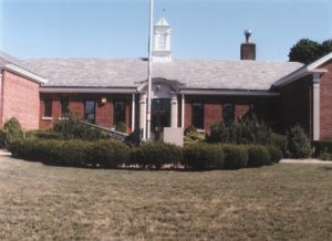
Beginning in 1950, officers from the Second Precinct were based in a one-story building on East Main Street constructed adjacent to Port Jefferson’s former First National Bank and operated out of this place until Jan. 1, 1960 when the Suffolk County Police absorbed the Brookhaven Town Police.
Afterwards, the space was occupied by the Brookhaven Town Tax Receiver and has housed retail stores in recent times.
Kenneth Brady has served as the Port Jefferson Village Historian and president of the Port Jefferson Conservancy, as well as on the boards of the Suffolk County Historical Society, Greater Port Jefferson Arts Council and Port Jefferson Historical Society. He is a longtime resident of Port Jefferson.
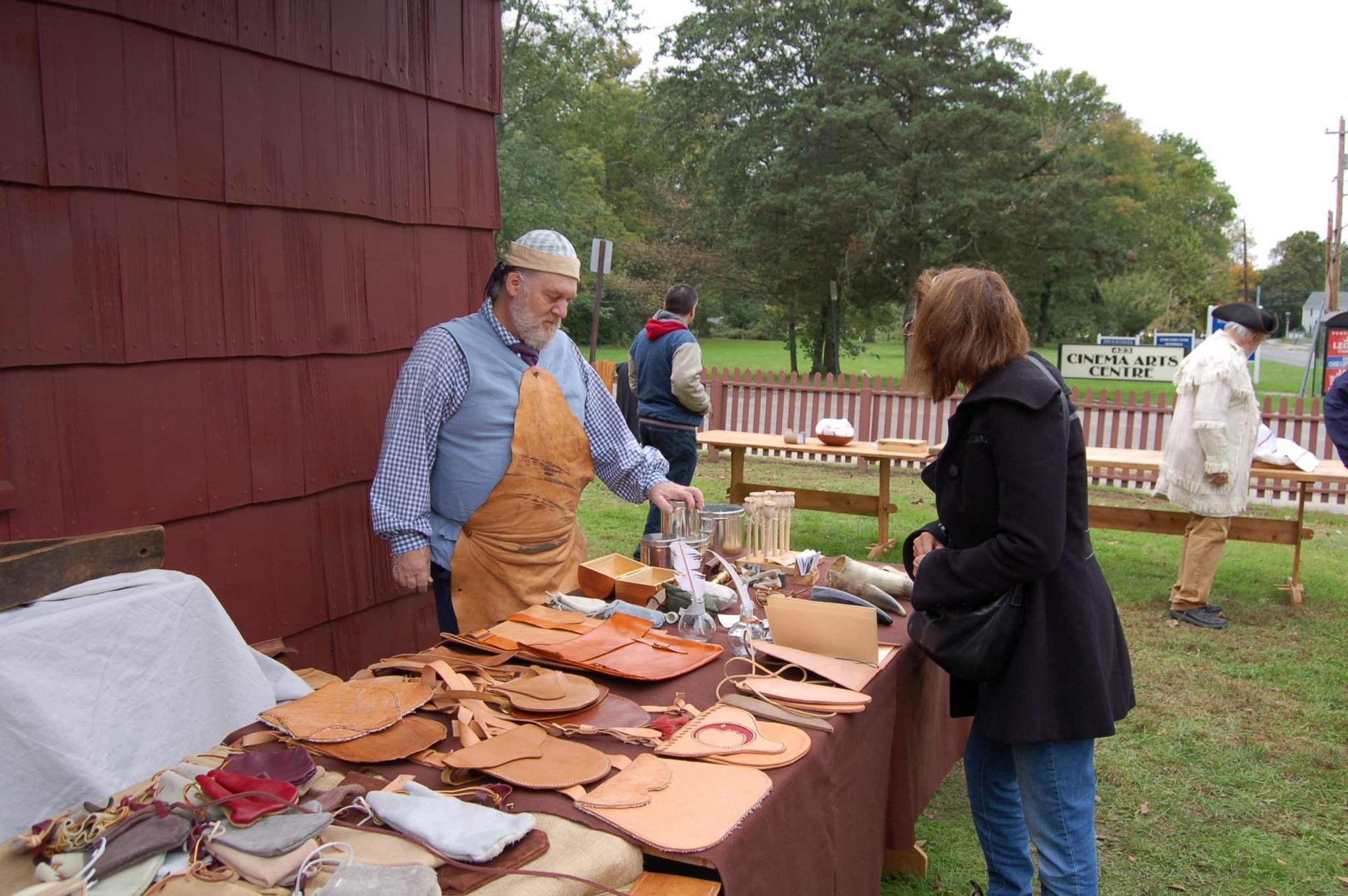
The Huntington Militia hosted a Colonial-era encampment in Huntington in October, 2018. Photo by Heidi Sutton
The Huntington Militia hosted a Colonial-era encampment in Huntington in October, 2018. Photo by Heidi Sutton
The Huntington Militia hosted a Colonial-era encampment in Huntington in October, 2018. Photo by Heidi Sutton
By Kimberly Brown
History comes alive this Sunday in Huntington as the Order of the Ancient and Honorable Huntington Militia hosts a Colonial Market Fair on the grounds of the Arsenal museum on Park Avenue from noon to 5 p.m.
While the Arsenal remains closed for tours, families can enjoy outdoor Colonial demonstrations that will focus on civilian crafts such as leather and horn work, silversmithing, sewing, weaving, papermaking, and cooking, accompanied by 18th century music.
“You’ll be able to see people doing these trades to make different crafts and then also be able to purchase the items that they basically made right in front of you,” said Patrick Mantle, Commander of the Huntington Militia. “These will be really unique items and there’s really nowhere else around here where you can get that experience.”
Visitors can also walk across the street to the Village Green to watch artillerymen demonstrate the loading and firing of a full-scale reproduction 18th century field cannon while Men at Arms drill and fire 18th Century muskets throughout the day.
Having a passion for history from a young age, Mantle always admired the Huntington Militia since he first saw them at a St. Patrick’s Day parade when he was four years old. Always wanting to be a significant part of the organization, Mantle’s dream was accomplished when he was promoted to Commander in 2016, only three years after joining.
“I was always the kid on the block who was marching around in a tricorne hat, wearing my father’s high socks and carrying my toy musket to emulate what a soldier would’ve looked like,” Mantle said. “Everyone would say ‘There goes Patrick again’ as I marched down the street with a flag.”
Since fourth grade Mantle knew he wanted to pursue a career in history, specifically studying the Revolutionary War. Taking a program focused on Revolutionary Era Studies while attending Siena College in Loudonville, New York aided Mantle in his knowledge when directing the reenactments.
“For all of us, it’s a hobby but anyone that you’ll meet that’s a reenactor will say it’s a passion because we wouldn’t be doing this if we didn’t love it,” he said.
Seeing the reactions to the reenactments from families is one of Mantle’s favorite parts of the event, as seeing history come to life opens up a new world for visitors interested in learning about the history of America and Long Island.
“Even the adults who attend our events, listen to me talk, and see our demonstration will come up to me later to say they just learned more in 30 minutes than they did in all their years of school,” Mantle said.
The Huntington Militia’s Colonial Market Fair will be held at The Arsenal, 425 Park Avenue, Huntington on Sunday, July 11 from noon to 5 p.m. Admission to the event is free. In case of rain, the event will be held on July 18.
The Huntington Militia will also be holding a virtual event on July 24 to discuss and celebrate Huntington’s Independence Day. Visit www.huntingtonmilitia.com or call 631-223-8017 for further details.
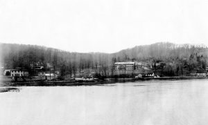
A western view of Cold Spring Harbor, above. The seawall is visible along the shoreline beneath the buildings. Photo from Cold Spring Harbor Laboratory
Over a decade before the Civil War, brothers John, Walter and Townsend Jones recognized that they needed to protect the land at Cold Spring Harbor from the effects of storms that flooded and eroded the shoreline.
The view circa 1910. Cold Spring Harbor Laboratory Archives
In 1850, they built a seawall using stones transported in three schooners from a Connecticut quarry to block water from coming ashore in what is now the picturesque coast of the Cold Spring Harbor Laboratory, according to the booklet “Cold Spring Harbor Rediscovering history in street and shores by Terry Walton.
Time and powerful storms, including Hurricane Sandy in 2012, have taken their toll on the protective seawall, causing weaknesses that might allow future storms or water surges to damage the internationally renowned lab and the surrounding area.
Cold Spring Harbor Laboratory will soon start an effort to rebuild and refurbish the seawall, preserving some of its historical value by reusing original stones. The refurbishing effort, which will cost $14 million and includes $500,000 from New York State, will take 10 to 11 months to complete.
The state funds have been appropriated and are in the process of being released from the New York State Department of Budget, according to State Senator James Gaughran (D-Northport). Gaughran said he helped secure the funds and is pleased with their design.
“I applaud Cold Spring Harbor [Laboratory] for incorporating the original stones in the seawall’s restoration, which will preserve the beauty of the historic seawall,” Gaughran explained in an email.
“It’s really a feat that it lasted as long as it has,” said Stephen Monez, facilities manager at CSHL. The designers originally built the wall by stacking stones on top of each other.
“We’re starting to lose elevation of our ground,” Monez said. Utility lines for a lab where four Nobel prize winners have conducted some of their research over the years and where numerous faculty continue to conduct basic and translational research run behind the seawall, increasing the importance of the effort.
The seawall, which the Jones brothers and their Cold Spring Harbor Whaling Company built, has failed in two places, according to Errol Kitt, vice president, principal and Long Island branch manager for GEI Consultants Inc, PC. Kitt, who runs the Huntington Station office of GEI, leads the team that developed design plans for the new seawall.
A national company, GEI has worked in other areas of historical significance, including Boston Harbor.
The Cold Spring Harbor seawall is an “interesting one, with reusing the stones,” Kitt said. “That’s the new twist to this.”
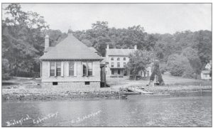
The original seawall. Photo from Cold Spring Harbor Whaling Museum
Kitt helped ensure that the plans would be consistent with the concerns of regulatory agencies.
“We came up with a preliminary design that we sought buy-in from the regulatory agencies early on,” Kitt said. “That helped move the project along.”
Skanska, a Swedish-based construction and engineering group, will oversee the work, while Triumph Construction will do the construction. Kitt said the team has permits in place to start construction and is awaiting the U.S. Army Corps of Engineers to finalize their permit.
The seawall had been protecting the area for four decades in the 19th century when the Biological Laboratory of the Brooklyn Institute of Arts and Sciences, a predecessor to CSHL, was established in 1890.
State and local authorities, including the New York State Historic Preservation Office, the U.S. Army Corps of Engineers and the Village of Laurel Hollow, have approved the plans to rebuild the wall.
Skanska, a Swedish-based construction and engineering group, will oversee the project, while Triumph Construction, of the Bronx, will do the building work. The Huntington Station office of GEI Consultants provided the design and engineering plans.
Triumph will use concrete and rebar to rebuild a seawall that will be 2 feet higher than the original. That is the maximum additional height the lab could add. The company will clean the original and historic stones, which they will then use to reface the seawall to retain its original look.
The New York State Historic Preservation wanted to ensure that the wall “would look as original as it was before we did this project,” Monez said.
In 2014, the lab started putting money aside to rebuild the seawall. In the last 18 months, the weather has caused erosion.
“Once a wall starts to go, it doesn’t take [long] for the rest of it” to weaken, Monez said.
The facilities team at CSHL recently closed the road along the shoreline.
The seawall will be longer than the original, with the team adding more to the structure on the landward side.
CSHL has put up a 10-foot high safety fence, has added warning signs to the area and mandated a hardhat area.
Members of the facilities staff are also receiving 10 hours of training from the Occupational Safety and Health Administration, a regulatory agency of the U.S. Department of Labor, in case they need to enter the area.
The construction team is putting in sheet piling prior to rebuilding the seawall to protect the land while they do the work. This will prevent any damage from tidal or storm surge over the next year until the project is complete.
The first two months of the work is likely to be the loudest part of the construction process.
“We met with scientists in adjacent buildings,” Monez said.
He said the effort will provide protection for the area amid storms and any rise in the sea level.
“We are installing our insurance policy for the future,” Monez said.


")